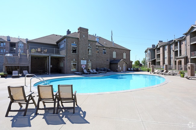
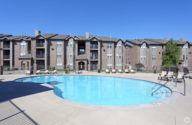
Property Record
2505 N 109Th Plz, Omaha, NE 68164

NEARBY LISTINGS FOR SALE OR LEASE
-
-
View all Omaha listings for sale on LoopNet.com
Property Detail
2505 N 109Th Plz
Omaha-Council Bluffs, NE-IA
Whispering Hills
3220-5002-25
WHISPERING HILLS LOT OLB BLOCK 0 IRREG .67 AC
Commercialnec
Douglas
X
Nebraska
31055C0212H
olb
2024
7.58 AC
2025
Northwest Omaha
0074402005
Omaha/Council Bluffs
148,675 SF
DEMOGRAPHICS near 2505 N 109Th Plz
1 Mile
3 Mile
5 Mile
2024 Total Population
14,494
91,063
234,366
2029 Population
14,634
92,103
237,091
Pop Growth 2024-2029
+ 0.97%
+ 1.14%
+ 1.16%
Average Age
35
40
39
2024 Total Households
7,288
39,812
96,226
HH Growth 2024-2029
+ 0.95%
+ 1.21%
+ 1.22%
Median Household Inc
$52,088
$70,431
$76,932
Avg Household Size
1.90
2.20
2.40
2024 Avg HH Vehicles
2.00
2.00
2.00
Median Home Value
$189,355
$230,795
$235,755
Median Year Built
1983
1978
1977
Nearby Places
Map Layers
Map Styles
 Street
 Aerial
- Restaurants
- Banks
- Shops
- Fitness
- Groceries
PUBLIC TRANSPORTATION
AIRPORT
Eppley Airfield
DRIVE
WALK
Distance
Eppley Airfield
26 min
13.0 mi
Freight Ports
Tulsa Port Of Catoosa
DRIVE
WALK
Distance
Tulsa Port Of Catoosa
476 min
428.1 mi
Nearby Properties
Address
Land Use
TOTAL SIZE
Lot Size
Zoning
Address
Land Use
TOTAL SIZE
Lot Size
Zoning
866,622 SF
20.67 AC
Address
Land Use
TOTAL SIZE
Lot Size
Zoning
496,976 SF
12 AC
Address
Land Use
TOTAL SIZE
Lot Size
Zoning
856,187 SF
36.41 AC
Address
Land Use
TOTAL SIZE
Lot Size
Zoning
549,971 SF
42.84 AC
R6
Address
Land Use
TOTAL SIZE
Lot Size
Zoning
584,213 SF
36.38 AC
R7
Address
Land Use
TOTAL SIZE
Lot Size
Zoning
702,563 SF
18.85 AC
Address
Land Use
TOTAL SIZE
Lot Size
Zoning
209,917 SF
9.52 AC
Address
Land Use
TOTAL SIZE
Lot Size
Zoning
548,510 SF
36.78 AC
Address
Land Use
TOTAL SIZE
Lot Size
Zoning
545,041 SF
22.69 AC
R6
Address
Land Use
TOTAL SIZE
Lot Size
Zoning
239,976 SF
20.13 AC
Address
Land Use
TOTAL SIZE
Lot Size
Zoning
250,386 SF
17.06 AC
Address
Land Use
TOTAL SIZE
Lot Size
Zoning
301,341 SF
15.04 AC
R6
Address
Land Use
TOTAL SIZE
Lot Size
Zoning
304,034 SF
5.11 AC
R7
Address
Land Use
TOTAL SIZE
Lot Size
Zoning
428,342 SF
18.62 AC
Address
Land Use
TOTAL SIZE
Lot Size
Zoning
398,593 SF
10.80 AC
Address
Land Use
TOTAL SIZE
Lot Size
Zoning
329,565 SF
7.72 AC
Address
Land Use
TOTAL SIZE
Lot Size
Zoning
460,264 SF
20.87 AC
Address
Land Use
TOTAL SIZE
Lot Size
Zoning
233,882 SF
9.49 AC
MU
Address
Land Use
TOTAL SIZE
Lot Size
Zoning
130,286 SF
4.31 AC
GO
Address
Land Use
TOTAL SIZE
Lot Size
Zoning
96,871 SF
9.98 AC
Address
Land Use
TOTAL SIZE
Lot Size
Zoning
238,954 SF
14.65 AC
Address
Land Use
TOTAL SIZE
Lot Size
Zoning
255,483 SF
14.25 AC
Address
Land Use
TOTAL SIZE
Lot Size
Zoning
420,264 SF
23.97 AC
R6
Address
Land Use
TOTAL SIZE
Lot Size
Zoning
329,515 SF
6.37 AC
Address
Land Use
TOTAL SIZE
Lot Size
Zoning
288,432 SF
12.98 AC
Address
Land Use
TOTAL SIZE
Lot Size
Zoning
234,332 SF
12.30 AC
Address
Land Use
TOTAL SIZE
Lot Size
Zoning
251,394 SF
14.71 AC
Address
Land Use
TOTAL SIZE
Lot Size
Zoning
136,340 SF
7.50 AC
MU
Address
Land Use
TOTAL SIZE
Lot Size
Zoning
255,205 SF
9.41 AC
R6
Address
Land Use
TOTAL SIZE
Lot Size
Zoning
248,169 SF
10.39 AC
The World's #1 Commercial Real Estate Marketplace
Connect with us
© 2026 CoStar Group
The information above has been obtained from sources believed reliable. While we do not doubt its accuracy we have not verified it and make no guarantee, warranty or representation about it. It is your responsibility to independently confirm its accuracy and completeness. Any projections, opinions, assumptions, or estimates used are for example only and do not represent the current or future performance of the property. The value of this transaction to you depends on tax and other factors which should be evaluated by your tax, financial, and legal advisors. You and your advisors should conduct a careful, independent investigation of the property to determine to your satisfaction the suitability of the property for your needs.