Property Record
2505 N Waverly Rd, Lansing, MI 48906
NEARBY LISTINGS FOR SALE OR LEASE
-
-
View all Lansing listings for sale on LoopNet.com
Property Detail
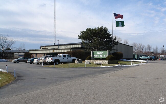
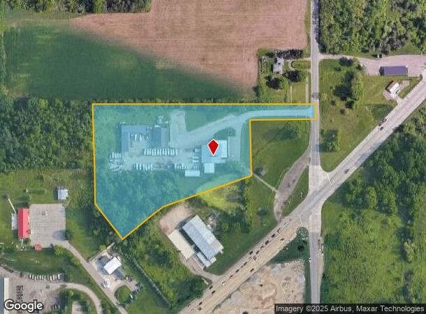
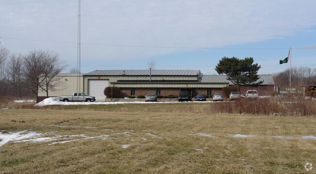
2505 N Waverly Rd
080-013-200-032-00
Ingersolls Addition
Officebuilding
COM NE COR SEC.13, W 910.65 FT, S 01DEG 38MIN 30SEC W 431.98 FT, S 37DEG 30MIN E 182.87 FT, N 52DEG 30SEC E 220 FT, N 70DEG 36MIN 18SEC E 382.27 FT, N 01DEG 38MIN E 234 FT, N 88DEG 33MIN 38SEC E 267.8 FT, N 66 FT TO BEG. SEC.13, T3N,R3W WINDSOR TWP 1
X
Eaton
26065C0138D
Michigan
2024
6.69 AC
2025
Outlying Eaton County
003200
West Michigan
20,576 SF
Lansing-East Lansing, MI
DEMOGRAPHICS near 2505 N Waverly Rd
1 Mile
3 Mile
5 Mile
2024 Total Population
1,421
35,439
90,492
2029 Population
1,419
35,274
90,144
Pop Growth 2024-2029
(0.14%)
(0.47%)
(0.38%)
Average Age
38
38
39
2024 Total Households
515
13,800
38,057
HH Growth 2024-2029
(0.39%)
(0.62%)
(0.49%)
Median Household Inc
$89,930
$57,717
$55,447
Avg Household Size
2.60
2.50
2.30
2024 Avg HH Vehicles
2.00
2.00
2.00
Median Home Value
$185,134
$146,487
$140,584
Median Year Built
1987
1972
1969
Nearby Places
Map Layers
Map Styles
 Street
 Aerial
- Restaurants
- Banks
- Shops
- Fitness
- Groceries
PUBLIC TRANSPORTATION
AIRPORT
Capital Region International
DRIVE
WALK
Distance
Capital Region International
18 min
9.4 mi
Freight Ports
Port of Toledo
DRIVE
WALK
Distance
Port of Toledo
146 min
124.6 mi
Nearby Properties
Address
Land Use
TOTAL SIZE
Lot Size
Zoning
Address
Land Use
TOTAL SIZE
Lot Size
Zoning
50,364 SF
25.57 AC
M-1
Address
Land Use
TOTAL SIZE
Lot Size
Zoning
75,476 SF
17.70 AC
Address
Land Use
TOTAL SIZE
Lot Size
Zoning
3,528 SF
230 AC
Address
Land Use
TOTAL SIZE
Lot Size
Zoning
8,469 SF
160 AC
Address
Land Use
TOTAL SIZE
Lot Size
Zoning
20,834 SF
11.85 AC
F COMM
Address
Land Use
TOTAL SIZE
Lot Size
Zoning
29,965 SF
4.52 AC
A-1
Address
Land Use
TOTAL SIZE
Lot Size
Zoning
1,496 SF
47.39 AC
RM-1
Address
Land Use
TOTAL SIZE
Lot Size
Zoning
135,318 SF
10.59 AC
G-2 WHO
Address
Land Use
TOTAL SIZE
Lot Size
Zoning
7,689 SF
148.47 AC
DM-1 RE
Address
Land Use
TOTAL SIZE
Lot Size
Zoning
3,006 SF
136 AC
DM-1 RE
Address
Land Use
TOTAL SIZE
Lot Size
Zoning
140,841 SF
199 AC
CUP
Address
Land Use
TOTAL SIZE
Lot Size
Zoning
126,015 SF
176 AC
CUP
Address
Land Use
TOTAL SIZE
Lot Size
Zoning
71,900 SF
5.08 AC
NONE
Address
Land Use
TOTAL SIZE
Lot Size
Zoning
43,150 SF
20.31 AC
NONE
Address
Land Use
TOTAL SIZE
Lot Size
Zoning
44,000 SF
5 AC
M-1
Address
Land Use
TOTAL SIZE
Lot Size
Zoning
50,000 SF
4.22 AC
NONE
Address
Land Use
TOTAL SIZE
Lot Size
Zoning
53.59 AC
DM-1 RE
Address
Land Use
TOTAL SIZE
Lot Size
Zoning
74,798 SF
80 AC
Address
Land Use
TOTAL SIZE
Lot Size
Zoning
1,800 SF
80 AC
CUP
Address
Land Use
TOTAL SIZE
Lot Size
Zoning
73,136 SF
78 AC
CUP
Address
Land Use
TOTAL SIZE
Lot Size
Zoning
73,742 SF
76 AC
Address
Land Use
TOTAL SIZE
Lot Size
Zoning
60,000 SF
45 AC
DM-1 RE
Address
Land Use
TOTAL SIZE
Lot Size
Zoning
5,201 SF
78 AC
Address
Land Use
TOTAL SIZE
Lot Size
Zoning
38,338 SF
2.12 AC
B-2
Address
Land Use
TOTAL SIZE
Lot Size
Zoning
90,078 SF
164 AC
CUP
Address
Land Use
TOTAL SIZE
Lot Size
Zoning
74,461 SF
76 AC
CUP
Address
Land Use
TOTAL SIZE
Lot Size
Zoning
68,292 SF
74 AC
Address
Land Use
TOTAL SIZE
Lot Size
Zoning
62,100 SF
9.57 AC
DM-1 RE
Address
Land Use
TOTAL SIZE
Lot Size
Zoning
63,792 SF
70 AC
Address
Land Use
TOTAL SIZE
Lot Size
Zoning
7,583 SF
10.34 AC
DM-1 RE
The World's #1 Commercial Real Estate Marketplace
Connect with us
© 2026 CoStar Group
The information above has been obtained from sources believed reliable. While we do not doubt its accuracy we have not verified it and make no guarantee, warranty or representation about it. It is your responsibility to independently confirm its accuracy and completeness. Any projections, opinions, assumptions, or estimates used are for example only and do not represent the current or future performance of the property. The value of this transaction to you depends on tax and other factors which should be evaluated by your tax, financial, and legal advisors. You and your advisors should conduct a careful, independent investigation of the property to determine to your satisfaction the suitability of the property for your needs.