Property Record
2505 S Belt Line Rd, Grand Prairie, TX 75052


NEARBY LISTINGS FOR SALE OR LEASE
Property Detail
2505 S Belt Line Rd
Dallas-Fort Worth-Arlington, TX
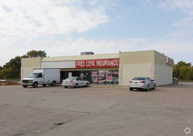
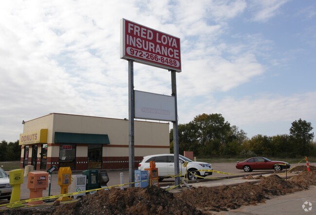
Chief Auto Parts-Grand Prairie
28025400000010000
CHIEF AUTO PARTS-GRAND PRAIRIE BLK 2540 TR 1 0.597 ACRES VOL99006/6885 DD121498 CO-DALLAS 0254000000100 22802540000
Storebuilding
Dallas
X
Texas
48113C0455M
1
2024
0.60 AC
2025
North Grand Prairie
016407
Dallas/Ft Worth
3,606 SF
DEMOGRAPHICS near 2505 S Belt Line Rd
1 Mile
3 Mile
5 Mile
2024 Total Population
20,436
78,570
209,545
2029 Population
20,153
78,038
211,843
Pop Growth 2024-2029
(1.38%)
(0.68%)
+ 1.10%
Average Age
35
35
35
2024 Total Households
6,138
24,661
67,726
HH Growth 2024-2029
(1.65%)
(0.88%)
+ 1.11%
Median Household Inc
$58,063
$62,197
$59,149
Avg Household Size
3.20
3.10
3.00
2024 Avg HH Vehicles
2.00
2.00
2.00
Median Home Value
$162,055
$192,558
$214,033
Median Year Built
1975
1982
1984
Nearby Places
Map Layers
Map Styles
 Street
 Aerial
- Restaurants
- Banks
- Shops
- Fitness
- Groceries
PUBLIC TRANSPORTATION
COMMUTER RAIL
DRIVE
WALK
Distance
14 min
9.7 mi
AIRPORT
Dallas-Fort Worth International
DRIVE
WALK
Distance
Dallas-Fort Worth International
25 min
17.0 mi
Dallas Love Field
DRIVE
WALK
Distance
Dallas Love Field
31 min
17.5 mi
Nearby Properties
Address
Land Use
TOTAL SIZE
Lot Size
Zoning
Address
Land Use
TOTAL SIZE
Lot Size
Zoning
2,395,314 SF
152.04 AC
Address
Land Use
TOTAL SIZE
Lot Size
Zoning
1,306,700 SF
87.99 AC
Address
Land Use
TOTAL SIZE
Lot Size
Zoning
459,985 SF
179.23 AC
Z06
Address
Land Use
TOTAL SIZE
Lot Size
Zoning
1,577,320 SF
122.55 AC
Z123
Address
Land Use
TOTAL SIZE
Lot Size
Zoning
860,445 SF
50.39 AC
Z123
Address
Land Use
TOTAL SIZE
Lot Size
Zoning
343,158 SF
18.42 AC
Z236
Address
Land Use
TOTAL SIZE
Lot Size
Zoning
485,300 SF
16.51 AC
Z312
Address
Land Use
TOTAL SIZE
Lot Size
Zoning
428,147 SF
14.45 AC
Z313
Address
Land Use
TOTAL SIZE
Lot Size
Zoning
301,120 SF
14.23 AC
Z313
Address
Land Use
TOTAL SIZE
Lot Size
Zoning
762,985 SF
74.96 AC
Z239
Address
Land Use
TOTAL SIZE
Lot Size
Zoning
266,460 SF
12 AC
Z313
Address
Land Use
TOTAL SIZE
Lot Size
Zoning
753,721 SF
42.65 AC
Address
Land Use
TOTAL SIZE
Lot Size
Zoning
478,110 SF
11.74 AC
Z313
Address
Land Use
TOTAL SIZE
Lot Size
Zoning
247,880 SF
20.93 AC
Z236
Address
Land Use
TOTAL SIZE
Lot Size
Zoning
1,054,767 SF
37.45 AC
Z123
Address
Land Use
TOTAL SIZE
Lot Size
Zoning
276,567 SF
14.52 AC
Z236
Address
Land Use
TOTAL SIZE
Lot Size
Zoning
603,000 SF
32.80 AC
Z123
Address
Land Use
TOTAL SIZE
Lot Size
Zoning
670,880 SF
38.60 AC
Z239
Address
Land Use
TOTAL SIZE
Lot Size
Zoning
663,000 SF
40.70 AC
Z116
Address
Land Use
TOTAL SIZE
Lot Size
Zoning
387,500 SF
13.54 AC
Z313
Address
Land Use
TOTAL SIZE
Lot Size
Zoning
297,393 SF
13.83 AC
Z236
Address
Land Use
TOTAL SIZE
Lot Size
Zoning
252,800 SF
21.59 AC
Z236
Address
Land Use
TOTAL SIZE
Lot Size
Zoning
272,000 SF
8.07 AC
Z313
Address
Land Use
TOTAL SIZE
Lot Size
Zoning
630,000 SF
46 AC
Z239
Address
Land Use
TOTAL SIZE
Lot Size
Zoning
228,210 SF
12.28 AC
Z190
Address
Land Use
TOTAL SIZE
Lot Size
Zoning
283,087 SF
15.22 AC
Z236
Address
Land Use
TOTAL SIZE
Lot Size
Zoning
436,343 SF
5.36 AC
Z236
Address
Land Use
TOTAL SIZE
Lot Size
Zoning
214,047 SF
13.78 AC
Z236
Address
Land Use
TOTAL SIZE
Lot Size
Zoning
150,000 SF
12.95 AC
Address
Land Use
TOTAL SIZE
Lot Size
Zoning
559,500 SF
32.60 AC
Z239
The World's #1 Commercial Real Estate Marketplace
Connect with us
© 2025 CoStar Group
The information above has been obtained from sources believed reliable. While we do not doubt its accuracy we have not verified it and make no guarantee, warranty or representation about it. It is your responsibility to independently confirm its accuracy and completeness. Any projections, opinions, assumptions, or estimates used are for example only and do not represent the current or future performance of the property. The value of this transaction to you depends on tax and other factors which should be evaluated by your tax, financial, and legal advisors. You and your advisors should conduct a careful, independent investigation of the property to determine to your satisfaction the suitability of the property for your needs.