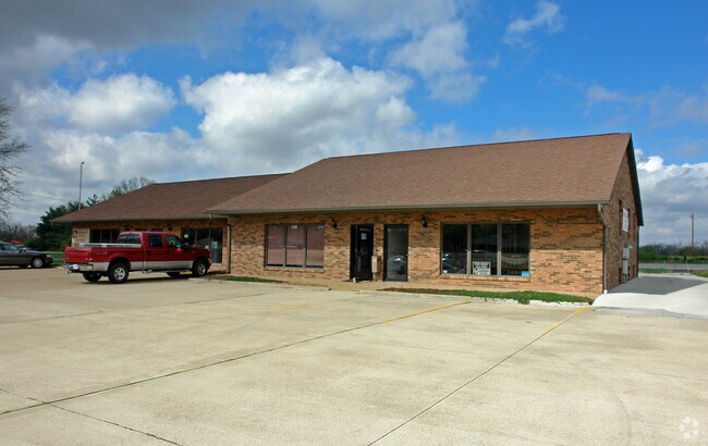
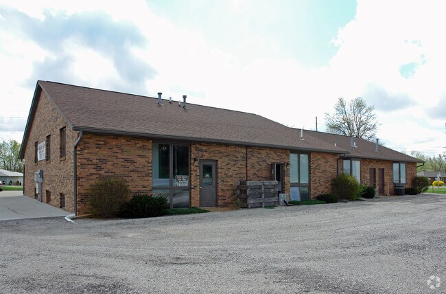
Property Record
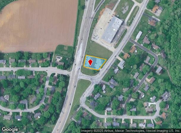
2505 Vandalia St, Collinsville, IL 62234
NEARBY LISTINGS FOR SALE OR LEASE
Property Detail
2505 Vandalia St
St. Louis, MO-IL
Maple Park
13-1-21-14-03-305-007
PT SE SW 133.55 X 151.06 IRR
Officebuilding
Madison
2024
Illinois
2024
0.52 AC
403502
Illinois
4,500 SF
St. Louis
DEMOGRAPHICS near 2505 Vandalia St
1 Mile
3 Mile
5 Mile
2024 Total Population
3,193
29,170
66,548
2029 Population
3,133
28,735
65,675
Pop Growth 2024-2029
(1.88%)
(1.49%)
(1.31%)
Average Age
45
42
41
2024 Total Households
1,374
12,455
27,210
HH Growth 2024-2029
(1.97%)
(1.54%)
(1.35%)
Median Household Inc
$73,970
$72,371
$77,145
Avg Household Size
2.20
2.30
2.40
2024 Avg HH Vehicles
2.00
2.00
2.00
Median Home Value
$179,100
$172,258
$185,147
Median Year Built
1980
1979
1981
Nearby Places
Map Layers
Map Styles
 Street
 Aerial
- Restaurants
- Banks
- Shops
- Fitness
- Groceries
PUBLIC TRANSPORTATION
AIRPORT
Scott AFB/Midamerica St Louis
DRIVE
WALK
Distance
Scott AFB/Midamerica St Louis
35 min
20.9 mi
St Louis Lambert International
DRIVE
WALK
Distance
St Louis Lambert International
38 min
27.6 mi
Nearby Properties
Address
Land Use
TOTAL SIZE
Lot Size
Zoning
Address
Land Use
TOTAL SIZE
Lot Size
Zoning
10.83 AC
Address
Land Use
TOTAL SIZE
Lot Size
Zoning
25,675 SF
3 AC
Address
Land Use
TOTAL SIZE
Lot Size
Zoning
131,296 SF
14.60 AC
Address
Land Use
TOTAL SIZE
Lot Size
Zoning
5,280 SF
3.69 AC
Address
Land Use
TOTAL SIZE
Lot Size
Zoning
72,233 SF
4.94 AC
Address
Land Use
TOTAL SIZE
Lot Size
Zoning
54,699 SF
2.20 AC
Address
Land Use
TOTAL SIZE
Lot Size
Zoning
12,900 SF
5.76 AC
Address
Land Use
TOTAL SIZE
Lot Size
Zoning
35,046 SF
6.82 AC
Address
Land Use
TOTAL SIZE
Lot Size
Zoning
84,816 SF
0.89 AC
Address
Land Use
TOTAL SIZE
Lot Size
Zoning
756 SF
8.77 AC
Address
Land Use
TOTAL SIZE
Lot Size
Zoning
96,702 SF
4.80 AC
Address
Land Use
TOTAL SIZE
Lot Size
Zoning
26,408 SF
2.94 AC
Address
Land Use
TOTAL SIZE
Lot Size
Zoning
5,475 SF
2.91 AC
Address
Land Use
TOTAL SIZE
Lot Size
Zoning
5,280 SF
2.72 AC
Address
Land Use
TOTAL SIZE
Lot Size
Zoning
64,411 SF
1.80 AC
Address
Land Use
TOTAL SIZE
Lot Size
Zoning
33,476 SF
Address
Land Use
TOTAL SIZE
Lot Size
Zoning
40,176 SF
7.44 AC
Address
Land Use
TOTAL SIZE
Lot Size
Zoning
31,024 SF
11.62 AC
Address
Land Use
TOTAL SIZE
Lot Size
Zoning
9,904 SF
5.50 AC
Address
Land Use
TOTAL SIZE
Lot Size
Zoning
40,994 SF
4 AC
Address
Land Use
TOTAL SIZE
Lot Size
Zoning
19,619 SF
1.43 AC
Address
Land Use
TOTAL SIZE
Lot Size
Zoning
45,334 SF
0.65 AC
Address
Land Use
TOTAL SIZE
Lot Size
Zoning
11,833 SF
1.80 AC
Address
Land Use
TOTAL SIZE
Lot Size
Zoning
7,929 SF
25.01 AC
Address
Land Use
TOTAL SIZE
Lot Size
Zoning
8,136 SF
1.58 AC
Address
Land Use
TOTAL SIZE
Lot Size
Zoning
2,048 SF
3.79 AC
Address
Land Use
TOTAL SIZE
Lot Size
Zoning
19,872 SF
0.35 AC
Address
Land Use
TOTAL SIZE
Lot Size
Zoning
14,478 SF
1.80 AC
Address
Land Use
TOTAL SIZE
Lot Size
Zoning
54,849 SF
0.79 AC
Address
Land Use
TOTAL SIZE
Lot Size
Zoning
13,952 SF
1.13 AC
The World's #1 Commercial Real Estate Marketplace
Connect with us
© 2025 CoStar Group
The information above has been obtained from sources believed reliable. While we do not doubt its accuracy we have not verified it and make no guarantee, warranty or representation about it. It is your responsibility to independently confirm its accuracy and completeness. Any projections, opinions, assumptions, or estimates used are for example only and do not represent the current or future performance of the property. The value of this transaction to you depends on tax and other factors which should be evaluated by your tax, financial, and legal advisors. You and your advisors should conduct a careful, independent investigation of the property to determine to your satisfaction the suitability of the property for your needs.