Property Record
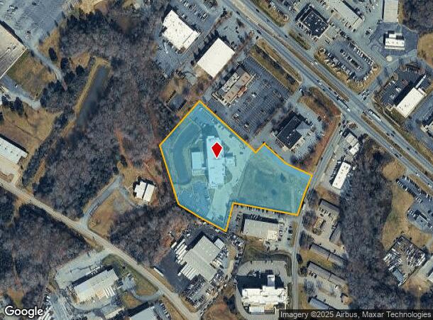
2505 W Roosevelt Blvd, Monroe, NC 28110
NEARBY LISTINGS FOR SALE OR LEASE
Property Detail
2505 W Roosevelt Blvd
Charlotte-Concord-Gastonia, NC-SC
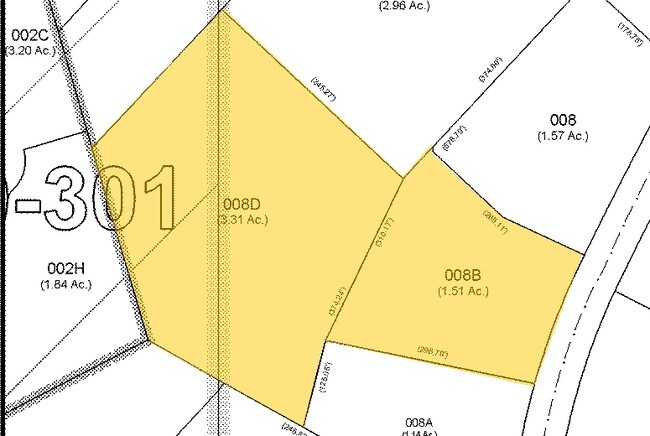
Monroe Corners Subdivision
09-261-008-B
LOT 4 MONROE CORNERS OPCJ338/OPCL172
Hotel
Union
X
North Carolina
3710543600J
4
2025
4.87 AC
2025
Union County
020405
Charlotte
62,865 SF
DEMOGRAPHICS near 2505 W Roosevelt Blvd
1 Mile
3 Mile
5 Mile
2024 Total Population
3,661
26,964
59,970
2029 Population
4,152
30,457
67,640
Pop Growth 2024-2029
+ 13.41%
+ 12.95%
+ 12.79%
Average Age
40
38
38
2024 Total Households
1,490
9,745
21,090
HH Growth 2024-2029
+ 13.56%
+ 13.11%
+ 12.95%
Median Household Inc
$59,039
$61,822
$69,740
Avg Household Size
2.40
2.70
2.80
2024 Avg HH Vehicles
2.00
2.00
2.00
Median Home Value
$255,688
$246,776
$265,119
Median Year Built
1990
1990
1993
Nearby Places
Map Layers
Map Styles
 Street
 Aerial
- Restaurants
- Banks
- Shops
- Fitness
- Groceries
PUBLIC TRANSPORTATION
AIRPORT
Charlotte/Douglas International
DRIVE
WALK
Distance
Charlotte/Douglas International
46 min
29.9 mi
Concord-Padgett Regional
DRIVE
WALK
Distance
Concord-Padgett Regional
45 min
34.2 mi
Freight Ports
North Charleston Terminal
DRIVE
WALK
Distance
North Charleston Terminal
225 min
187.2 mi
Nearby Properties
Address
Land Use
TOTAL SIZE
Lot Size
Zoning
Address
Land Use
TOTAL SIZE
Lot Size
Zoning
148,145 SF
26.68 AC
G-I MONROE
Address
Land Use
TOTAL SIZE
Lot Size
Zoning
78.48 AC
Address
Land Use
TOTAL SIZE
Lot Size
Zoning
30,708 SF
29.10 AC
R-MF MONRO
Address
Land Use
TOTAL SIZE
Lot Size
Zoning
124.87 AC
LI UNION C
Address
Land Use
TOTAL SIZE
Lot Size
Zoning
150,880 SF
73.40 AC
G-I MONROE
Address
Land Use
TOTAL SIZE
Lot Size
Zoning
18,208 SF
12.09 AC
R-MF MONRO
Address
Land Use
TOTAL SIZE
Lot Size
Zoning
99,235 SF
1.92 AC
CBD MONROE
Address
Land Use
TOTAL SIZE
Lot Size
Zoning
57,664 SF
45.15 AC
R-20 MONRO
Address
Land Use
TOTAL SIZE
Lot Size
Zoning
166,254 SF
99.20 AC
G-I MONROE
Address
Land Use
TOTAL SIZE
Lot Size
Zoning
81,504 SF
30.21 AC
CD MONROE
Address
Land Use
TOTAL SIZE
Lot Size
Zoning
82.26 AC
G-I MONROE
Address
Land Use
TOTAL SIZE
Lot Size
Zoning
2,048 SF
17.71 AC
GB MONROE
Address
Land Use
TOTAL SIZE
Lot Size
Zoning
24.89 AC
Address
Land Use
TOTAL SIZE
Lot Size
Zoning
71,831 SF
67.94 AC
CD MONROE
Address
Land Use
TOTAL SIZE
Lot Size
Zoning
219,625 SF
36.12 AC
GB MONROE
Address
Land Use
TOTAL SIZE
Lot Size
Zoning
159,892 SF
15.84 AC
G-I MONROE
Address
Land Use
TOTAL SIZE
Lot Size
Zoning
95,700 SF
24.87 AC
G-I MONROE
Address
Land Use
TOTAL SIZE
Lot Size
Zoning
97,083 SF
32.30 AC
R-40 MONRO
Address
Land Use
TOTAL SIZE
Lot Size
Zoning
79,493 SF
18.97 AC
CD MONROE
Address
Land Use
TOTAL SIZE
Lot Size
Zoning
54,712 SF
10.01 AC
GB MONROE
Address
Land Use
TOTAL SIZE
Lot Size
Zoning
123,296 SF
9.70 AC
CD MONROE
Address
Land Use
TOTAL SIZE
Lot Size
Zoning
5.89 AC
G-I MONROE
Address
Land Use
TOTAL SIZE
Lot Size
Zoning
13,141 SF
174.76 AC
G-I MONROE
Address
Land Use
TOTAL SIZE
Lot Size
Zoning
40,291 SF
3.59 AC
CD MONROE
Address
Land Use
TOTAL SIZE
Lot Size
Zoning
1,920 SF
9.99 AC
R-MF MONRO
Address
Land Use
TOTAL SIZE
Lot Size
Zoning
14.77 AC
Address
Land Use
TOTAL SIZE
Lot Size
Zoning
6,440 SF
2.23 AC
GB MONROE
Address
Land Use
TOTAL SIZE
Lot Size
Zoning
101,035 SF
26.11 AC
G-I MONROE
Address
Land Use
TOTAL SIZE
Lot Size
Zoning
9,072 SF
15.23 AC
R-MF MONRO
The World's #1 Commercial Real Estate Marketplace
Connect with us
© 2026 CoStar Group
The information above has been obtained from sources believed reliable. While we do not doubt its accuracy we have not verified it and make no guarantee, warranty or representation about it. It is your responsibility to independently confirm its accuracy and completeness. Any projections, opinions, assumptions, or estimates used are for example only and do not represent the current or future performance of the property. The value of this transaction to you depends on tax and other factors which should be evaluated by your tax, financial, and legal advisors. You and your advisors should conduct a careful, independent investigation of the property to determine to your satisfaction the suitability of the property for your needs.