Property Record
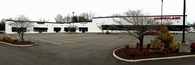
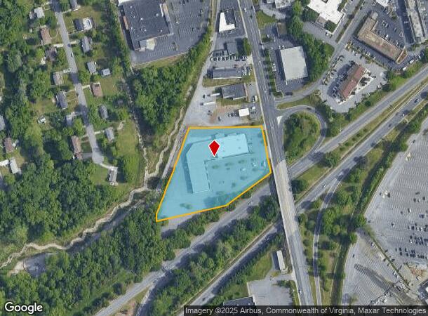
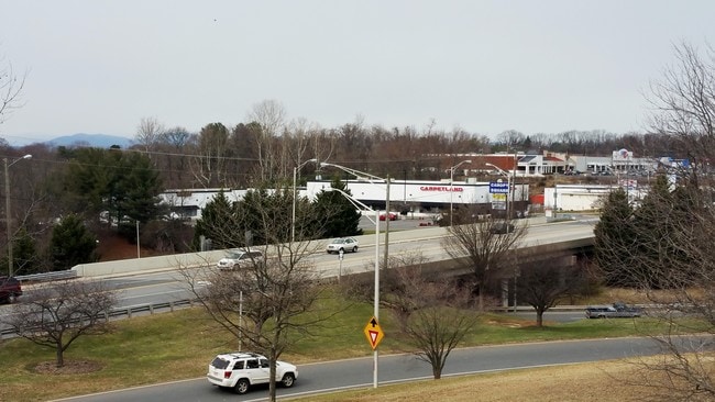
2505 Wards Rd, Lynchburg, VA 24502
Current Lease Availabilities
NEARBY LISTINGS FOR SALE OR LEASE
Property Detail
2505 Wards Rd
162-28-001
Wards Rd Commercial Corridor
Communitycenter
MONTVIEW
X
Lynchburg City
51019C0400D
Virginia
2025
3.09 AC
2025
Lynchburg
000901
Other Market Areas
32,103 SF
Lynchburg, VA
DEMOGRAPHICS near 2505 Wards Rd
1 Mile
3 Mile
5 Mile
2024 Total Population
4,209
38,345
89,934
2029 Population
4,196
38,487
90,394
Pop Growth 2024-2029
(0.31%)
+ 0.37%
+ 0.51%
Average Age
38
35
37
2024 Total Households
1,605
15,262
37,162
HH Growth 2024-2029
(0.37%)
+ 0.36%
+ 0.53%
Median Household Inc
$53,913
$54,734
$53,999
Avg Household Size
2.20
2.20
2.20
2024 Avg HH Vehicles
2.00
2.00
2.00
Median Home Value
$160,318
$157,214
$175,619
Median Year Built
1968
1972
1973
Nearby Places
- Restaurants
- Banks
- Shops
- Fitness
- Groceries
PUBLIC TRANSPORTATION
COMMUTER RAIL
Lynchburg (Crescent - Amtrak, Northeast Regional - Amtrak)
DRIVE
WALK
Distance
Lynchburg (Crescent - Amtrak, Northeast Regional - Amtrak)
7 min
4.1 mi
AIRPORT
Lynchburg Regional/Preston Glenn Field
DRIVE
WALK
Distance
Lynchburg Regional/Preston Glenn Field
10 min
4.0 mi
Freight Ports
Virginia Port Authority - Richmond
DRIVE
WALK
Distance
Virginia Port Authority - Richmond
152 min
112.3 mi
Nearby Properties
Address
Land Use
TOTAL SIZE
Lot Size
Zoning
Address
Land Use
TOTAL SIZE
Lot Size
Zoning
1,116,411 SF
186.88 AC
B5
Address
Land Use
TOTAL SIZE
Lot Size
Zoning
816,228 SF
54.13 AC
B5I2
Address
Land Use
TOTAL SIZE
Lot Size
Zoning
814,428 SF
99.03 AC
212923
Address
Land Use
TOTAL SIZE
Lot Size
Zoning
3.33 AC
1909
Address
Land Use
TOTAL SIZE
Lot Size
Zoning
22.70 AC
Address
Land Use
TOTAL SIZE
Lot Size
Zoning
323,985 SF
50.89 AC
2305
Address
Land Use
TOTAL SIZE
Lot Size
Zoning
400,209 SF
26.87 AC
B5
Address
Land Use
TOTAL SIZE
Lot Size
Zoning
326,293 SF
80.06 AC
R1R3
Address
Land Use
TOTAL SIZE
Lot Size
Zoning
1,282 SF
12.75 AC
Address
Land Use
TOTAL SIZE
Lot Size
Zoning
Address
Land Use
TOTAL SIZE
Lot Size
Zoning
1,200 SF
73.13 AC
Address
Land Use
TOTAL SIZE
Lot Size
Zoning
207,379 SF
10.24 AC
250905
Address
Land Use
TOTAL SIZE
Lot Size
Zoning
4,672 SF
905.07 AC
BHC
Address
Land Use
TOTAL SIZE
Lot Size
Zoning
163,760 SF
12 AC
Address
Land Use
TOTAL SIZE
Lot Size
Zoning
199,056 SF
16.21 AC
R1
Address
Land Use
TOTAL SIZE
Lot Size
Zoning
17,210 SF
14.35 AC
Address
Land Use
TOTAL SIZE
Lot Size
Zoning
8,259 SF
13.02 AC
Address
Land Use
TOTAL SIZE
Lot Size
Zoning
181,808 SF
39.61 AC
192921
Address
Land Use
TOTAL SIZE
Lot Size
Zoning
221,676 SF
102.07 AC
231529
Address
Land Use
TOTAL SIZE
Lot Size
Zoning
387,080 SF
18.30 AC
1509
Address
Land Use
TOTAL SIZE
Lot Size
Zoning
Address
Land Use
TOTAL SIZE
Lot Size
Zoning
284,151 SF
70.13 AC
I3
Address
Land Use
TOTAL SIZE
Lot Size
Zoning
86,855 SF
10.68 AC
B1
Address
Land Use
TOTAL SIZE
Lot Size
Zoning
1,241 SF
7.20 AC
2519
Address
Land Use
TOTAL SIZE
Lot Size
Zoning
10.13 AC
R4RC
Address
Land Use
TOTAL SIZE
Lot Size
Zoning
267,447 SF
28.46 AC
B3
Address
Land Use
TOTAL SIZE
Lot Size
Zoning
173,573 SF
8.80 AC
Address
Land Use
TOTAL SIZE
Lot Size
Zoning
161,688 SF
16.57 AC
R3RC
Address
Land Use
TOTAL SIZE
Lot Size
Zoning
222,427 SF
23.56 AC
I2RC
Address
Land Use
TOTAL SIZE
Lot Size
Zoning
103,515 SF
25.04 AC
B5R1
The World's #1 Commercial Real Estate Marketplace
Connect with us
© 2025 CoStar Group
The information above has been obtained from sources believed reliable. While we do not doubt its accuracy we have not verified it and make no guarantee, warranty or representation about it. It is your responsibility to independently confirm its accuracy and completeness. Any projections, opinions, assumptions, or estimates used are for example only and do not represent the current or future performance of the property. The value of this transaction to you depends on tax and other factors which should be evaluated by your tax, financial, and legal advisors. You and your advisors should conduct a careful, independent investigation of the property to determine to your satisfaction the suitability of the property for your needs.