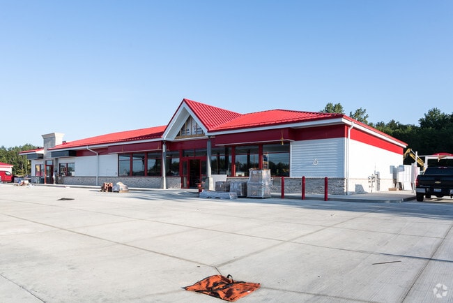
Property Record
2506 Locust St S, Canal Fulton, OH 44614

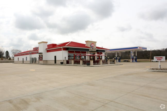
NEARBY LISTINGS FOR SALE OR LEASE
Property Detail
2506 Locust St S
10008807
PT OL 170 - 4.00A
Servicestation
Stark
X
Ohio
39153C0270F
4 AC
0
Stark County
2025
Cleveland
711211
Canton-Massillon, OH
10,904 SF
DEMOGRAPHICS near 2506 Locust St S
1 Mile
3 Mile
5 Mile
2024 Total Population
1,760
17,928
46,496
2029 Population
1,744
17,736
45,897
Pop Growth 2024-2029
(0.91%)
(1.07%)
(1.29%)
Average Age
49
43
43
2024 Total Households
789
6,858
18,296
HH Growth 2024-2029
(0.89%)
(1.14%)
(1.34%)
Median Household Inc
$87,792
$93,355
$90,765
Avg Household Size
2.20
2.60
2.50
2024 Avg HH Vehicles
2.00
2.00
2.00
Median Home Value
$173,677
$219,570
$221,167
Median Year Built
1985
1979
1976
Nearby Places
Map Layers
Map Styles
 Street
 Aerial
- Restaurants
- Banks
- Shops
- Fitness
- Groceries
PUBLIC TRANSPORTATION
AIRPORT
Akron-Canton Regional
DRIVE
WALK
Distance
Akron-Canton Regional
17 min
9.2 mi
Freight Ports
Port of Toledo
DRIVE
WALK
Distance
Port of Toledo
175 min
147.3 mi
Nearby Properties
Address
Land Use
TOTAL SIZE
Lot Size
Zoning
Address
Land Use
TOTAL SIZE
Lot Size
Zoning
Address
Land Use
TOTAL SIZE
Lot Size
Zoning
110,937 SF
56.25 AC
Address
Land Use
TOTAL SIZE
Lot Size
Zoning
49,558 SF
328.80 AC
Address
Land Use
TOTAL SIZE
Lot Size
Zoning
103,903 SF
15.02 AC
Address
Land Use
TOTAL SIZE
Lot Size
Zoning
110,301 SF
22.70 AC
Address
Land Use
TOTAL SIZE
Lot Size
Zoning
99,887 SF
14.82 AC
Address
Land Use
TOTAL SIZE
Lot Size
Zoning
24,592 SF
3.45 AC
Address
Land Use
TOTAL SIZE
Lot Size
Zoning
115,200 SF
7.20 AC
Address
Land Use
TOTAL SIZE
Lot Size
Zoning
24,914 SF
5.07 AC
Address
Land Use
TOTAL SIZE
Lot Size
Zoning
18,681 SF
6.01 AC
Address
Land Use
TOTAL SIZE
Lot Size
Zoning
150,895 SF
31.91 AC
Address
Land Use
TOTAL SIZE
Lot Size
Zoning
10,248 SF
158.32 AC
Address
Land Use
TOTAL SIZE
Lot Size
Zoning
26,914 SF
3.23 AC
Address
Land Use
TOTAL SIZE
Lot Size
Zoning
49,041 SF
16.73 AC
Address
Land Use
TOTAL SIZE
Lot Size
Zoning
111,464 SF
10.90 AC
Address
Land Use
TOTAL SIZE
Lot Size
Zoning
117,773 SF
35.60 AC
Address
Land Use
TOTAL SIZE
Lot Size
Zoning
28,990 SF
4.95 AC
Address
Land Use
TOTAL SIZE
Lot Size
Zoning
28,163 SF
3.32 AC
Address
Land Use
TOTAL SIZE
Lot Size
Zoning
60,000 SF
5.30 AC
Address
Land Use
TOTAL SIZE
Lot Size
Zoning
26,003 SF
2.67 AC
Address
Land Use
TOTAL SIZE
Lot Size
Zoning
7,481 SF
36.98 AC
Address
Land Use
TOTAL SIZE
Lot Size
Zoning
6,749 SF
50.29 AC
Address
Land Use
TOTAL SIZE
Lot Size
Zoning
17,112 SF
3.56 AC
Address
Land Use
TOTAL SIZE
Lot Size
Zoning
12,242 SF
6.68 AC
Address
Land Use
TOTAL SIZE
Lot Size
Zoning
13,887 SF
1.57 AC
Address
Land Use
TOTAL SIZE
Lot Size
Zoning
32,867 SF
3.79 AC
Address
Land Use
TOTAL SIZE
Lot Size
Zoning
153.20 AC
Address
Land Use
TOTAL SIZE
Lot Size
Zoning
14,080 SF
0.62 AC
Address
Land Use
TOTAL SIZE
Lot Size
Zoning
11,695 SF
11.64 AC
The World's #1 Commercial Real Estate Marketplace
Connect with us
© 2026 CoStar Group
The information above has been obtained from sources believed reliable. While we do not doubt its accuracy we have not verified it and make no guarantee, warranty or representation about it. It is your responsibility to independently confirm its accuracy and completeness. Any projections, opinions, assumptions, or estimates used are for example only and do not represent the current or future performance of the property. The value of this transaction to you depends on tax and other factors which should be evaluated by your tax, financial, and legal advisors. You and your advisors should conduct a careful, independent investigation of the property to determine to your satisfaction the suitability of the property for your needs.