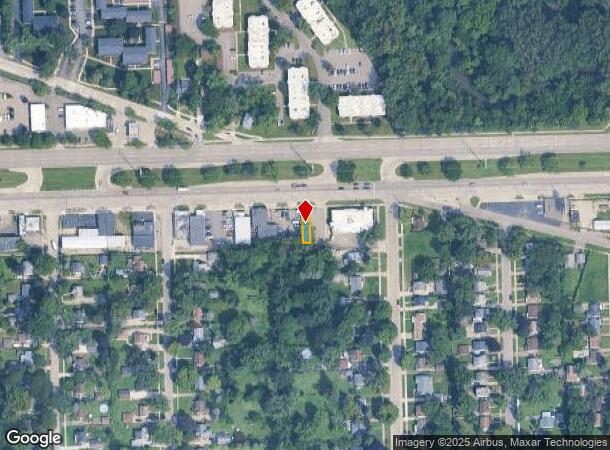
Property Record
25081 W 8 Mile Rd, Redford, MI 48240
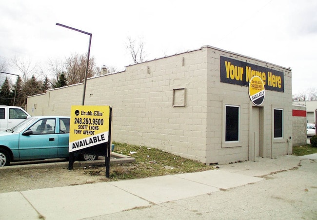
This Property Is For Sale
NEARBY LISTINGS FOR SALE OR LEASE
Property Detail
25081 W 8 Mile Rd
Detroit-Warren-Dearborn, MI
Rodgers Park
79-001-01-0997-000
05A997 LOT 997 ROGERS PARK NO. 4 SUB T1S R10E L60 P77 WCR
Manufacturinglight
Wayne
X
Michigan
26163C0060E
997
2024
0.05 AC
2025
Livonia
554100
Detroit
1,980 SF
DEMOGRAPHICS near 25081 W 8 Mile Rd
1 Mile
3 Mile
5 Mile
2024 Total Population
9,513
91,652
260,181
2029 Population
9,205
89,526
254,241
Pop Growth 2024-2029
(3.24%)
(2.32%)
(2.28%)
Average Age
39
41
41
2024 Total Households
4,216
39,211
109,250
HH Growth 2024-2029
(3.30%)
(2.35%)
(2.29%)
Median Household Inc
$41,785
$49,824
$57,620
Avg Household Size
2.20
2.30
2.30
2024 Avg HH Vehicles
1.00
2.00
2.00
Median Home Value
$97,145
$129,437
$165,284
Median Year Built
1956
1957
1958
Nearby Places
- Restaurants
- Banks
- Shops
- Fitness
- Groceries
PUBLIC TRANSPORTATION
AIRPORT
Detroit Metro Wayne County
DRIVE
WALK
Distance
Detroit Metro Wayne County
38 min
20.8 mi
Windsor International
DRIVE
WALK
Distance
Windsor International
47 min
28.5 mi
Nearby Properties
Address
Land Use
TOTAL SIZE
Lot Size
Zoning
Address
Land Use
TOTAL SIZE
Lot Size
Zoning
383,602 SF
36.60 AC
I-1
Address
Land Use
TOTAL SIZE
Lot Size
Zoning
301,269 SF
25.47 AC
OS
Address
Land Use
TOTAL SIZE
Lot Size
Zoning
405,020 SF
18.74 AC
RMM
Address
Land Use
TOTAL SIZE
Lot Size
Zoning
325,654 SF
7.45 AC
ERO
Address
Land Use
TOTAL SIZE
Lot Size
Zoning
311,298 SF
31.66 AC
BI
Address
Land Use
TOTAL SIZE
Lot Size
Zoning
209,000 SF
11.21 AC
ERO
Address
Land Use
TOTAL SIZE
Lot Size
Zoning
210 SF
20.52 AC
R-2
Address
Land Use
TOTAL SIZE
Lot Size
Zoning
304 SF
6.99 AC
RC
Address
Land Use
TOTAL SIZE
Lot Size
Zoning
307,002 SF
14.61 AC
RC
Address
Land Use
TOTAL SIZE
Lot Size
Zoning
174 SF
14.17 AC
RM
Address
Land Use
TOTAL SIZE
Lot Size
Zoning
202,736 SF
20 AC
PD
Address
Land Use
TOTAL SIZE
Lot Size
Zoning
397,200 SF
14.07 AC
RMU
Address
Land Use
TOTAL SIZE
Lot Size
Zoning
143,700 SF
3.27 AC
PD
Address
Land Use
TOTAL SIZE
Lot Size
Zoning
97,082 SF
67.47 AC
TV-R
Address
Land Use
TOTAL SIZE
Lot Size
Zoning
124,306 SF
5.04 AC
ERO-M
Address
Land Use
TOTAL SIZE
Lot Size
Zoning
129 SF
15.16 AC
RM
Address
Land Use
TOTAL SIZE
Lot Size
Zoning
164,964 SF
14.96 AC
R-7
Address
Land Use
TOTAL SIZE
Lot Size
Zoning
158,092 SF
11.75 AC
B-3
Address
Land Use
TOTAL SIZE
Lot Size
Zoning
204 SF
11.31 AC
RM
Address
Land Use
TOTAL SIZE
Lot Size
Zoning
138,104 SF
8.66 AC
AI
Address
Land Use
TOTAL SIZE
Lot Size
Zoning
190,000 SF
7.84 AC
ERO-M
Address
Land Use
TOTAL SIZE
Lot Size
Zoning
635,934 SF
31 AC
ERO-M
Address
Land Use
TOTAL SIZE
Lot Size
Zoning
106,867 SF
ERO
Address
Land Use
TOTAL SIZE
Lot Size
Zoning
143,941 SF
11.66 AC
PD
Address
Land Use
TOTAL SIZE
Lot Size
Zoning
192,038 SF
16.26 AC
C-2
Address
Land Use
TOTAL SIZE
Lot Size
Zoning
168 SF
13.03 AC
RMM
Address
Land Use
TOTAL SIZE
Lot Size
Zoning
153,860 SF
7.93 AC
ERO-M
Address
Land Use
TOTAL SIZE
Lot Size
Zoning
160,046 SF
7.47 AC
ERO-M
Address
Land Use
TOTAL SIZE
Lot Size
Zoning
86,973 SF
5.99 AC
OS
Address
Land Use
TOTAL SIZE
Lot Size
Zoning
115,270 SF
7.07 AC
AI
The World's #1 Commercial Real Estate Marketplace
Connect with us
© 2025 CoStar Group
The information above has been obtained from sources believed reliable. While we do not doubt its accuracy we have not verified it and make no guarantee, warranty or representation about it. It is your responsibility to independently confirm its accuracy and completeness. Any projections, opinions, assumptions, or estimates used are for example only and do not represent the current or future performance of the property. The value of this transaction to you depends on tax and other factors which should be evaluated by your tax, financial, and legal advisors. You and your advisors should conduct a careful, independent investigation of the property to determine to your satisfaction the suitability of the property for your needs.