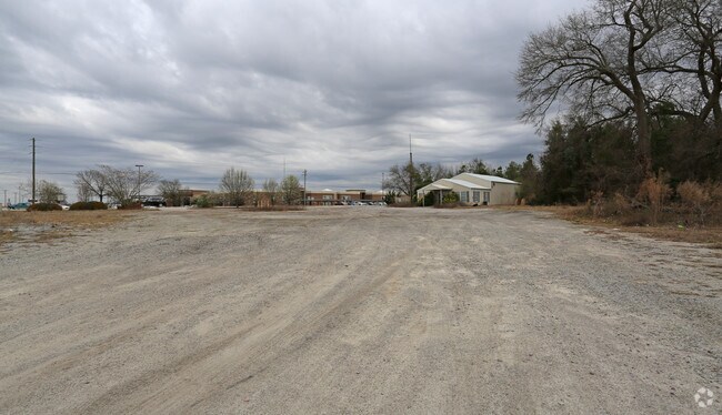
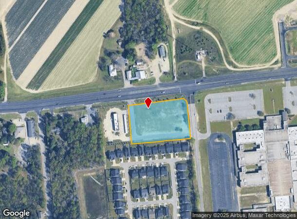
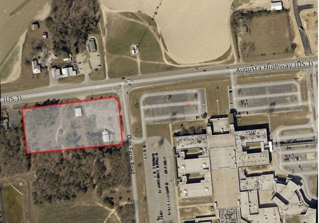
Property Record
2509 Augusta Hwy, Lexington, SC 29072
NEARBY LISTINGS FOR SALE OR LEASE
Property Detail
2509 Augusta Hwy
Columbia, SC
Landtyech Inc
005300-05-003
LOT 2B
Commercialacreage
Lexington
X
South Carolina
45063C0231J
2b
2025
2.47 AC
2024
Lexington
021023
Columbia
1,823 SF
DEMOGRAPHICS near 2509 Augusta Hwy
1 Mile
3 Mile
5 Mile
2024 Total Population
3,723
23,702
52,369
2029 Population
4,032
25,799
57,243
Pop Growth 2024-2029
+ 8.30%
+ 8.85%
+ 9.31%
Average Age
36
37
40
2024 Total Households
1,357
8,412
19,408
HH Growth 2024-2029
+ 8.47%
+ 9.02%
+ 9.54%
Median Household Inc
$80,810
$94,067
$86,841
Avg Household Size
2.70
2.80
2.60
2024 Avg HH Vehicles
2.00
2.00
2.00
Median Home Value
$210,960
$242,463
$258,506
Median Year Built
2004
2004
2001
Nearby Places
Map Layers
Map Styles
 Street
 Aerial
- Restaurants
- Banks
- Shops
- Fitness
- Groceries
PUBLIC TRANSPORTATION
AIRPORT
Columbia Metro
DRIVE
WALK
Distance
Columbia Metro
35 min
16.8 mi
Freight Ports
North Charleston Terminal
DRIVE
WALK
Distance
North Charleston Terminal
136 min
114.6 mi
SALE & LEASE HISTORY
LISTING DATE
SALE/LEASE

Jul 10, 2017
For Sale
Feb 24, 2017
For Sale
Nearby Properties
Address
Land Use
TOTAL SIZE
Lot Size
Zoning
Address
Land Use
TOTAL SIZE
Lot Size
Zoning
45,171 SF
8.38 AC
ID
Address
Land Use
TOTAL SIZE
Lot Size
Zoning
96,585 SF
2.62 AC
ID
Address
Land Use
TOTAL SIZE
Lot Size
Zoning
49,494 SF
9.98 AC
ID
Address
Land Use
TOTAL SIZE
Lot Size
Zoning
3,810 SF
1.58 AC
ID
Address
Land Use
TOTAL SIZE
Lot Size
Zoning
6,760 SF
1.50 AC
ID
Address
Land Use
TOTAL SIZE
Lot Size
Zoning
4,850 SF
1.88 AC
ID
Address
Land Use
TOTAL SIZE
Lot Size
Zoning
12,600 SF
2.06 AC
ID
Address
Land Use
TOTAL SIZE
Lot Size
Zoning
121.12 AC
RD
Address
Land Use
TOTAL SIZE
Lot Size
Zoning
39,473 SF
5.95 AC
ID
Address
Land Use
TOTAL SIZE
Lot Size
Zoning
16,465 SF
182.78 AC
ID
Address
Land Use
TOTAL SIZE
Lot Size
Zoning
5,175 SF
1.61 AC
ID
Address
Land Use
TOTAL SIZE
Lot Size
Zoning
4,098 SF
0.99 AC
ID
Address
Land Use
TOTAL SIZE
Lot Size
Zoning
10,776 SF
2.10 AC
ID
Address
Land Use
TOTAL SIZE
Lot Size
Zoning
14,494 SF
2.17 AC
ID
Address
Land Use
TOTAL SIZE
Lot Size
Zoning
1,800 SF
43.80 AC
ID
Address
Land Use
TOTAL SIZE
Lot Size
Zoning
13,870 SF
3.55 AC
ID
Address
Land Use
TOTAL SIZE
Lot Size
Zoning
1,042 SF
6.25 AC
ID
Address
Land Use
TOTAL SIZE
Lot Size
Zoning
5,029 SF
1.84 AC
ID
Address
Land Use
TOTAL SIZE
Lot Size
Zoning
4,800 SF
4.55 AC
ID
Address
Land Use
TOTAL SIZE
Lot Size
Zoning
13,231 SF
2.40 AC
ID
Address
Land Use
TOTAL SIZE
Lot Size
Zoning
4,400 SF
5.14 AC
ID
Address
Land Use
TOTAL SIZE
Lot Size
Zoning
1,250 SF
7.63 AC
ID
Address
Land Use
TOTAL SIZE
Lot Size
Zoning
34,679 SF
5.42 AC
ID
Address
Land Use
TOTAL SIZE
Lot Size
Zoning
4,148 SF
2.92 AC
ID
Address
Land Use
TOTAL SIZE
Lot Size
Zoning
9,600 SF
1.57 AC
GC
Address
Land Use
TOTAL SIZE
Lot Size
Zoning
8,161 SF
2.11 AC
ID
Address
Land Use
TOTAL SIZE
Lot Size
Zoning
10,640 SF
1.90 AC
RD
Address
Land Use
TOTAL SIZE
Lot Size
Zoning
8,769 SF
1.45 AC
ID
Address
Land Use
TOTAL SIZE
Lot Size
Zoning
7,700 SF
1.15 AC
ID
Address
Land Use
TOTAL SIZE
Lot Size
Zoning
5,068 SF
5.48 AC
ID
The World's #1 Commercial Real Estate Marketplace
Connect with us
© 2025 CoStar Group
The information above has been obtained from sources believed reliable. While we do not doubt its accuracy we have not verified it and make no guarantee, warranty or representation about it. It is your responsibility to independently confirm its accuracy and completeness. Any projections, opinions, assumptions, or estimates used are for example only and do not represent the current or future performance of the property. The value of this transaction to you depends on tax and other factors which should be evaluated by your tax, financial, and legal advisors. You and your advisors should conduct a careful, independent investigation of the property to determine to your satisfaction the suitability of the property for your needs.