Property Record
2501 Navigation Blvd, Houston, TX 77003
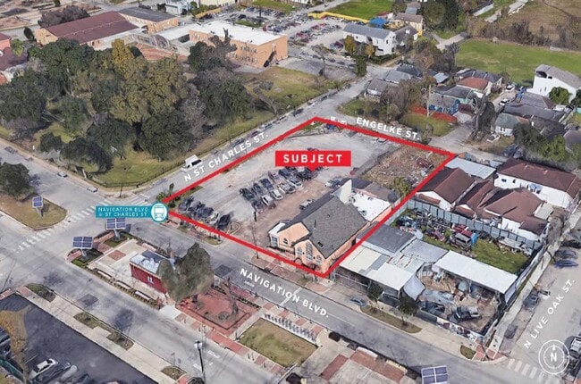

Property Detail
2501 Navigation Blvd
Houston-Pasadena-The Woodlands, TX
LTS 3 & 4 BLK 1 SETTEGAST SEC 1
0321940000003
HARRIS
Commercialnec
Texas
B and X Area of moderate flood hazard, usually the area between the limits of the 100-year and 500-year floods.
3,4
2024
0.23 AC
2025
Gulf Freeway/Pasadena
310101
Houston
NEARBY LISTINGS FOR SALE OR LEASE
DEMOGRAPHICS near 2501 Navigation Blvd
1 mile
3 mile
5 mile
2024 Total Population
24,022
191,055
460,374
2029 Population
25,580
206,884
498,355
Pop Growth 2024-2029
+ 6.49%
+ 8.29%
+ 8.25%
Average Age
38
37
38
2024 Total Households
6,923
79,137
197,091
HH Growth 2024-2029
+ 10.36%
+ 9.36%
+ 8.95%
Median Household Inc
$85,565
$70,900
$79,151
Avg Household Size
1.90
2.10
2.10
2024 Avg HH Vehicles
1.00
1.00
2.00
Median Home Value
$364,655
$366,129
$413,737
Median Year Built
2008
1991
1989
Nearby Places
Map Layers
Map Styles
 Street
 Aerial
Transit
 Traffic
 Biking
Places
Listings with unknown addresses are not visible on the map
- Restaurants
- Banks
- Shops
- Fitness
- Groceries
PUBLIC TRANSPORTATION
TRANSIT/SUBWAY
Eado / Stadium Stn Eb (METRORAIL GREEN LINE - Metropolitan Transit Authority of Harris County, METRORAIL PURPLE LINE - Metropolitan Transit Authority of Harris County)
Drive
Walk
Distance
Eado / Stadium Stn Eb (METRORAIL GREEN LINE - Metropolitan Transit Authority of Harris County, METRORAIL PURPLE LINE - Metropolitan Transit Authority of Harris County)
1 min
17 min
0.9 mi
Convention District Capitol Wb (METRORAIL GREEN LINE - Metropolitan Transit Authority of Harris County, METRORAIL PURPLE LINE - Metropolitan Transit Authority of Harris County)
Drive
Walk
Distance
Convention District Capitol Wb (METRORAIL GREEN LINE - Metropolitan Transit Authority of Harris County, METRORAIL PURPLE LINE - Metropolitan Transit Authority of Harris County)
1 min
18 min
0.9 mi
Coffee Plant / 2Nd Ward Eb (METRORAIL GREEN LINE - Metropolitan Transit Authority of Harris County, METRORAIL PURPLE LINE - Metropolitan Transit Authority of Harris County)
Drive
Walk
Distance
Coffee Plant / 2Nd Ward Eb (METRORAIL GREEN LINE - Metropolitan Transit Authority of Harris County, METRORAIL PURPLE LINE - Metropolitan Transit Authority of Harris County)
2 min
20 min
1.1 mi
Convention District Rusk Eb (METRORAIL GREEN LINE - Metropolitan Transit Authority of Harris County, METRORAIL PURPLE LINE - Metropolitan Transit Authority of Harris County)
Drive
Walk
Distance
Convention District Rusk Eb (METRORAIL GREEN LINE - Metropolitan Transit Authority of Harris County, METRORAIL PURPLE LINE - Metropolitan Transit Authority of Harris County)
2 min
20 min
1.1 mi
COMMUTER RAIL
Houston (Sunset Limited - Amtrak)
Drive
Walk
Distance
Houston (Sunset Limited - Amtrak)
5 min
1.9 mi
AIRPORT
William P Hobby
Drive
Walk
Distance
William P Hobby
23 min
12.0 mi
George Bush Intcntl/Houston
Drive
Walk
Distance
George Bush Intcntl/Houston
26 min
18.3 mi
Freight Ports
Port of Houston
Drive
Walk
Distance
Port of Houston
16 min
7.4 mi
SALE & LEASE HISTORY
LISTING DATE
SALE/LEASE

Mar 06, 2020
For Sale
Jun 10, 2021
For Lease
Jun 10, 2021
For Sale
Feb 08, 2021
For Lease
Nearby Properties
Address
Land Use
TOTAL SIZE
Lot Size
Zoning
Address
Land Use
TOTAL SIZE
Lot Size
Zoning
1,383,720 SF
1.47 AC
Address
Land Use
TOTAL SIZE
Lot Size
Zoning
1,101,686 SF
1.45 AC
Address
Land Use
TOTAL SIZE
Lot Size
Zoning
973,861 SF
1.18 AC
Address
Land Use
TOTAL SIZE
Lot Size
Zoning
899,279 SF
1.18 AC
Address
Land Use
TOTAL SIZE
Lot Size
Zoning
797,208 SF
1.46 AC
Address
Land Use
TOTAL SIZE
Lot Size
Zoning
1,916,394 SF
1.46 AC
Address
Land Use
TOTAL SIZE
Lot Size
Zoning
1,871,418 SF
1.44 AC
Address
Land Use
TOTAL SIZE
Lot Size
Zoning
1,091,726 SF
2.60 AC
Address
Land Use
TOTAL SIZE
Lot Size
Zoning
1,232,364 SF
1.49 AC
Address
Land Use
TOTAL SIZE
Lot Size
Zoning
1,436,400 SF
1.44 AC
Address
Land Use
TOTAL SIZE
Lot Size
Zoning
1,321,033 SF
1.46 AC
Address
Land Use
TOTAL SIZE
Lot Size
Zoning
2,005,097 SF
1.44 AC
Address
Land Use
TOTAL SIZE
Lot Size
Zoning
1,374,271 SF
1.44 AC
Address
Land Use
TOTAL SIZE
Lot Size
Zoning
1,150,681 SF
1.17 AC
Address
Land Use
TOTAL SIZE
Lot Size
Zoning
515,025 SF
1.50 AC
Address
Land Use
TOTAL SIZE
Lot Size
Zoning
1,657,484 SF
1.44 AC
Address
Land Use
TOTAL SIZE
Lot Size
Zoning
1,282,908 SF
2.74 AC
Address
Land Use
TOTAL SIZE
Lot Size
Zoning
1,311,133 SF
1.44 AC
Address
Land Use
TOTAL SIZE
Lot Size
Zoning
1,181,384 SF
1.47 AC
Address
Land Use
TOTAL SIZE
Lot Size
Zoning
1,162,204 SF
1.44 AC
Address
Land Use
TOTAL SIZE
Lot Size
Zoning
934,258 SF
1.45 AC
Address
Land Use
TOTAL SIZE
Lot Size
Zoning
1,103,424 SF
1.44 AC
Address
Land Use
TOTAL SIZE
Lot Size
Zoning
1,365,801 SF
1.44 AC
Address
Land Use
TOTAL SIZE
Lot Size
Zoning
1,017,783 SF
1.44 AC
Address
Land Use
TOTAL SIZE
Lot Size
Zoning
1,182,525 SF
1.11 AC
Address
Land Use
TOTAL SIZE
Lot Size
Zoning
608,233 SF
2.23 AC
Address
Land Use
TOTAL SIZE
Lot Size
Zoning
930,730 SF
1.89 AC
Address
Land Use
TOTAL SIZE
Lot Size
Zoning
612,078 SF
1.44 AC
Address
Land Use
TOTAL SIZE
Lot Size
Zoning
468,513 SF
0.86 AC
Address
Land Use
TOTAL SIZE
Lot Size
Zoning
1,075,210 SF
2.26 AC
The World's #1 Commercial Real Estate Marketplace
Connect with us
© 2026 CoStar Group
The information above has been obtained from sources believed reliable. While we do not doubt its accuracy we have not verified it and make no guarantee, warranty or representation about it. It is your responsibility to independently confirm its accuracy and completeness. Any projections, opinions, assumptions, or estimates used are for example only and do not represent the current or future performance of the property. The value of this transaction to you depends on tax and other factors which should be evaluated by your tax, financial, and legal advisors. You and your advisors should conduct a careful, independent investigation of the property to determine to your satisfaction the suitability of the property for your needs.