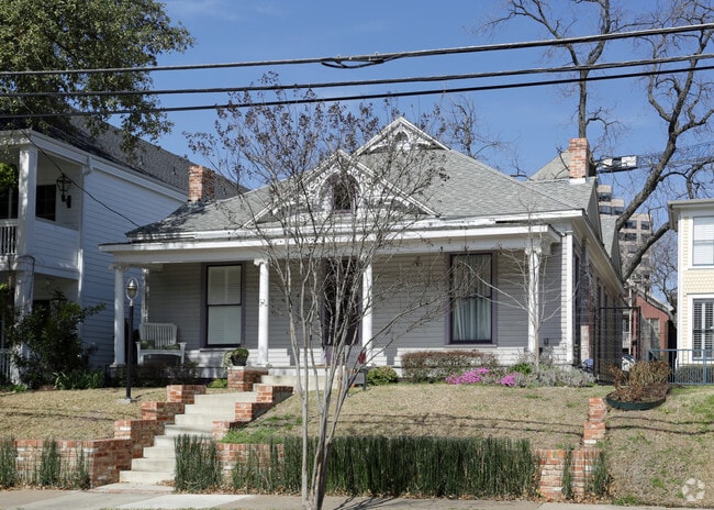
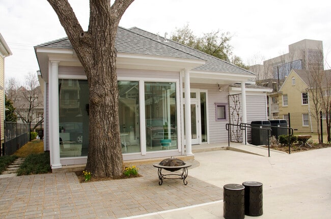
Property Record
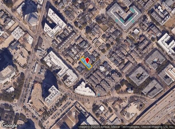
2509 Thomas Ave, Dallas, TX 75201
Current Lease Availabilities
NEARBY LISTINGS FOR SALE OR LEASE
Property Detail
2509 Thomas Ave
Dallas-Fort Worth-Arlington, TX
Thomas
00000113131000000
THOMAS BLK D/550 LOT 10 INT201000059496 DD03102010 CO-DC 0550 00D 010 1000550D000
Commercialnec
Dallas
X
Texas
48113C0345J
10
2024
0.17 AC
2025
Uptown
001705
Dallas/Ft Worth
1,824 SF
DEMOGRAPHICS near 2509 Thomas Ave
1 Mile
3 Mile
5 Mile
2024 Total Population
48,385
200,444
396,485
2029 Population
49,394
204,169
400,313
Pop Growth 2024-2029
+ 2.09%
+ 1.86%
+ 0.97%
Average Age
36
37
37
2024 Total Households
31,942
109,201
185,547
HH Growth 2024-2029
+ 1.94%
+ 1.83%
+ 1.10%
Median Household Inc
$93,099
$74,766
$71,678
Avg Household Size
1.50
1.70
2.00
2024 Avg HH Vehicles
1.00
1.00
2.00
Median Home Value
$407,805
$442,433
$448,240
Median Year Built
2005
2000
1991
Nearby Places
- Restaurants
- Banks
- Shops
- Fitness
- Groceries
PUBLIC TRANSPORTATION
TRANSIT/SUBWAY
Mckinney And Fairmount - North (McKinney Avenue Streetcar - Dallas Area Rapid Transit (DART))
DRIVE
WALK
Distance
Mckinney And Fairmount - North (McKinney Avenue Streetcar - Dallas Area Rapid Transit (DART))
0 min
3 min
0.2 mi
Mckinney And Routh - South (McKinney Avenue Streetcar - Dallas Area Rapid Transit (DART))
DRIVE
WALK
Distance
Mckinney And Routh - South (McKinney Avenue Streetcar - Dallas Area Rapid Transit (DART))
0 min
4 min
0.2 mi
Mckinney And Pearl - South (McKinney Avenue Streetcar - Dallas Area Rapid Transit (DART))
DRIVE
WALK
Distance
Mckinney And Pearl - South (McKinney Avenue Streetcar - Dallas Area Rapid Transit (DART))
0 min
4 min
0.2 mi
Mckinney And Boll - North (McKinney Avenue Streetcar - Dallas Area Rapid Transit (DART))
DRIVE
WALK
Distance
Mckinney And Boll - North (McKinney Avenue Streetcar - Dallas Area Rapid Transit (DART))
1 min
5 min
0.3 mi
Mckinney And Olive (McKinney Avenue Streetcar - Dallas Area Rapid Transit (DART))
DRIVE
WALK
Distance
Mckinney And Olive (McKinney Avenue Streetcar - Dallas Area Rapid Transit (DART))
1 min
5 min
0.3 mi
COMMUTER RAIL
Victory Station (DART LIGHT RAIL - GREEN LINE - Dallas Area Rapid Transit (DART), DART LIGHT RAIL - ORANGE LINE - Dallas Area Rapid Transit (DART), TRINITY RAILWAY - Dallas Area Rapid Transit (DART))
DRIVE
WALK
Distance
Victory Station (DART LIGHT RAIL - GREEN LINE - Dallas Area Rapid Transit (DART), DART LIGHT RAIL - ORANGE LINE - Dallas Area Rapid Transit (DART), TRINITY RAILWAY - Dallas Area Rapid Transit (DART))
3 min
18 min
1.0 mi
Medical/Market Ctr Station (TRINITY RAILWAY - Dallas Area Rapid Transit (DART))
DRIVE
WALK
Distance
Medical/Market Ctr Station (TRINITY RAILWAY - Dallas Area Rapid Transit (DART))
6 min
2.9 mi
AIRPORT
Dallas Love Field
DRIVE
WALK
Distance
Dallas Love Field
10 min
5.0 mi
Dallas-Fort Worth International
DRIVE
WALK
Distance
Dallas-Fort Worth International
27 min
20.0 mi
Freight Ports
Port of Shreveport
DRIVE
WALK
Distance
Port of Shreveport
213 min
197.0 mi
Nearby Properties
Address
Land Use
TOTAL SIZE
Lot Size
Zoning
Address
Land Use
TOTAL SIZE
Lot Size
Zoning
2,658,374 SF
37.70 AC
Z116
Address
Land Use
TOTAL SIZE
Lot Size
Zoning
3,713,071 SF
9.94 AC
Address
Land Use
TOTAL SIZE
Lot Size
Zoning
1,298,826 SF
33.16 AC
Z163
Address
Land Use
TOTAL SIZE
Lot Size
Zoning
815,000 SF
7.20 AC
Z239
Address
Land Use
TOTAL SIZE
Lot Size
Zoning
1,676,176 SF
2.18 AC
Z239
Address
Land Use
TOTAL SIZE
Lot Size
Zoning
906,730 SF
3.09 AC
Z239
Address
Land Use
TOTAL SIZE
Lot Size
Zoning
1,003,498 SF
22.15 AC
Z116
Address
Land Use
TOTAL SIZE
Lot Size
Zoning
1,308,710 SF
8.42 AC
Z21
Address
Land Use
TOTAL SIZE
Lot Size
Zoning
299,170 SF
9.71 AC
Z97
Address
Land Use
TOTAL SIZE
Lot Size
Zoning
731,849 SF
3.13 AC
Z239
Address
Land Use
TOTAL SIZE
Lot Size
Zoning
1,896,570 SF
18.08 AC
Z151
Address
Land Use
TOTAL SIZE
Lot Size
Zoning
1,480,246 SF
1.86 AC
Z21
Address
Land Use
TOTAL SIZE
Lot Size
Zoning
1,291,660 SF
2.56 AC
Z248
Address
Land Use
TOTAL SIZE
Lot Size
Zoning
1,026,046 SF
2.89 AC
Z248
Address
Land Use
TOTAL SIZE
Lot Size
Zoning
864,909 SF
3.02 AC
Z248
Address
Land Use
TOTAL SIZE
Lot Size
Zoning
504,533 SF
9.95 AC
Z151
Address
Land Use
TOTAL SIZE
Lot Size
Zoning
1,001,504 SF
3.37 AC
Z151
Address
Land Use
TOTAL SIZE
Lot Size
Zoning
1,424,070 SF
1.36 AC
Z21
Address
Land Use
TOTAL SIZE
Lot Size
Zoning
724,979 SF
1.05 AC
Z239
Address
Land Use
TOTAL SIZE
Lot Size
Zoning
893,159 SF
1.17 AC
Z21
Address
Land Use
TOTAL SIZE
Lot Size
Zoning
1,980,000 SF
2.57 AC
Z21
Address
Land Use
TOTAL SIZE
Lot Size
Zoning
857,292 SF
1.47 AC
Z239
Address
Land Use
TOTAL SIZE
Lot Size
Zoning
602,716 SF
11.21 AC
Z239
Address
Land Use
TOTAL SIZE
Lot Size
Zoning
763,198 SF
3.01 AC
Z248
Address
Land Use
TOTAL SIZE
Lot Size
Zoning
638,046 SF
2.11 AC
Z239
Address
Land Use
TOTAL SIZE
Lot Size
Zoning
486,300 SF
1.55 AC
Z239
Address
Land Use
TOTAL SIZE
Lot Size
Zoning
906,627 SF
3.83 AC
Z239
Address
Land Use
TOTAL SIZE
Lot Size
Zoning
653,557 SF
0.68 AC
Z248
Address
Land Use
TOTAL SIZE
Lot Size
Zoning
676,930 SF
1.38 AC
Z248
Address
Land Use
TOTAL SIZE
Lot Size
Zoning
536,874 SF
1.03 AC
Z239
The World's #1 Commercial Real Estate Marketplace
Connect with us
© 2025 CoStar Group
The information above has been obtained from sources believed reliable. While we do not doubt its accuracy we have not verified it and make no guarantee, warranty or representation about it. It is your responsibility to independently confirm its accuracy and completeness. Any projections, opinions, assumptions, or estimates used are for example only and do not represent the current or future performance of the property. The value of this transaction to you depends on tax and other factors which should be evaluated by your tax, financial, and legal advisors. You and your advisors should conduct a careful, independent investigation of the property to determine to your satisfaction the suitability of the property for your needs.