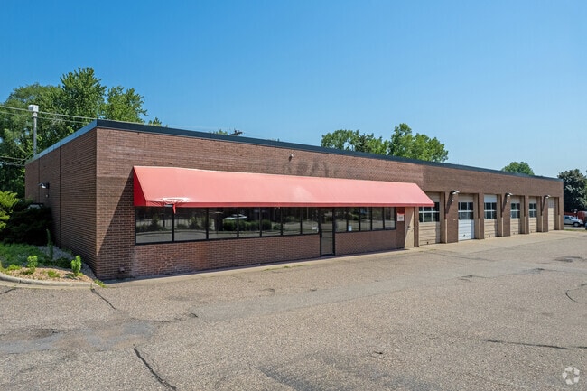
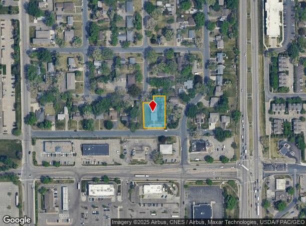
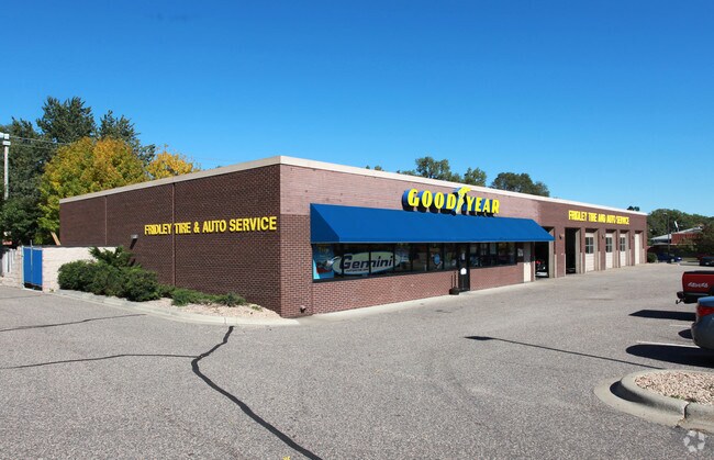
Property Record
251 57Th Pl Ne, Minneapolis, MN 55432

NEARBY LISTINGS FOR SALE OR LEASE
Property Detail
251 57Th Pl Ne
Minneapolis-St. Paul-Bloomington, MN-WI
City View
23-30-24-23-0153
LOTS 1 THRU 3 INCL BLOCK 2 CITY VIEW, TOG/W PRT OF ADJ VAC 571/2 AVE NE, SUBJ TO EASE OF REC
Apartment
Anoka
X
Minnesota
27053C0209F
1-3
2025
0.39 AC
2025
Northtown
051201
Minneapolis/St Paul
4,207 SF
DEMOGRAPHICS near 251 57Th Pl Ne
1 Mile
3 Mile
5 Mile
2024 Total Population
10,324
102,950
284,313
2029 Population
10,669
103,561
281,596
Pop Growth 2024-2029
+ 3.34%
+ 0.59%
(0.96%)
Average Age
38
38
38
2024 Total Households
4,250
38,430
108,230
HH Growth 2024-2029
+ 3.46%
+ 0.71%
(1.03%)
Median Household Inc
$60,655
$71,032
$70,086
Avg Household Size
2.30
2.60
2.50
2024 Avg HH Vehicles
2.00
2.00
2.00
Median Home Value
$240,988
$251,407
$256,412
Median Year Built
1964
1965
1965
Nearby Places
Map Layers
Map Styles
 Street
 Aerial
- Restaurants
- Banks
- Shops
- Fitness
- Groceries
PUBLIC TRANSPORTATION
COMMUTER RAIL
Fridley Station (Northstar Corridor - Northstar Commuter Rail)
DRIVE
WALK
Distance
Fridley Station (Northstar Corridor - Northstar Commuter Rail)
4 min
1.8 mi
Target Field Station (Northstar Corridor - Northstar Commuter Rail)
DRIVE
WALK
Distance
Target Field Station (Northstar Corridor - Northstar Commuter Rail)
14 min
8.3 mi
AIRPORT
Minneapolis-St Paul International/Wold-Chamberlain
DRIVE
WALK
Distance
Minneapolis-St Paul International/Wold-Chamberlain
33 min
20.1 mi
Freight Ports
Port Milwaukee
DRIVE
WALK
Distance
Port Milwaukee
380 min
344.3 mi
SALE & LEASE HISTORY
LISTING DATE
SALE/LEASE

Mar 13, 2023
For Lease
Jan 31, 2022
For Lease
Jan 31, 2022
For Sale
Nearby Properties
Address
Land Use
TOTAL SIZE
Lot Size
Zoning
Address
Land Use
TOTAL SIZE
Lot Size
Zoning
47,727 SF
17.03 AC
Address
Land Use
TOTAL SIZE
Lot Size
Zoning
35,488 SF
39.07 AC
Address
Land Use
TOTAL SIZE
Lot Size
Zoning
Address
Land Use
TOTAL SIZE
Lot Size
Zoning
663,908 SF
109.91 AC
Address
Land Use
TOTAL SIZE
Lot Size
Zoning
66,342 SF
8.85 AC
Address
Land Use
TOTAL SIZE
Lot Size
Zoning
264,574 SF
12.71 AC
Address
Land Use
TOTAL SIZE
Lot Size
Zoning
166.50 AC
Address
Land Use
TOTAL SIZE
Lot Size
Zoning
249,357 SF
6 AC
Address
Land Use
TOTAL SIZE
Lot Size
Zoning
19,514 SF
70.59 AC
Address
Land Use
TOTAL SIZE
Lot Size
Zoning
539,671 SF
26.93 AC
Address
Land Use
TOTAL SIZE
Lot Size
Zoning
249,884 SF
Address
Land Use
TOTAL SIZE
Lot Size
Zoning
334,568 SF
30.27 AC
Address
Land Use
TOTAL SIZE
Lot Size
Zoning
266,084 SF
15.60 AC
Address
Land Use
TOTAL SIZE
Lot Size
Zoning
393,252 SF
40 AC
Address
Land Use
TOTAL SIZE
Lot Size
Zoning
27,175 SF
1.86 AC
Address
Land Use
TOTAL SIZE
Lot Size
Zoning
Address
Land Use
TOTAL SIZE
Lot Size
Zoning
255,324 SF
15.22 AC
Address
Land Use
TOTAL SIZE
Lot Size
Zoning
106,897 SF
4.37 AC
Address
Land Use
TOTAL SIZE
Lot Size
Zoning
12.37 AC
Address
Land Use
TOTAL SIZE
Lot Size
Zoning
Address
Land Use
TOTAL SIZE
Lot Size
Zoning
213,984 SF
12.21 AC
Address
Land Use
TOTAL SIZE
Lot Size
Zoning
194,221 SF
27.83 AC
Address
Land Use
TOTAL SIZE
Lot Size
Zoning
173,183 SF
18.87 AC
Address
Land Use
TOTAL SIZE
Lot Size
Zoning
Address
Land Use
TOTAL SIZE
Lot Size
Zoning
Address
Land Use
TOTAL SIZE
Lot Size
Zoning
196 SF
9.81 AC
Address
Land Use
TOTAL SIZE
Lot Size
Zoning
169,628 SF
2.67 AC
Address
Land Use
TOTAL SIZE
Lot Size
Zoning
10.28 AC
Address
Land Use
TOTAL SIZE
Lot Size
Zoning
213,200 SF
13.21 AC
Address
Land Use
TOTAL SIZE
Lot Size
Zoning
190,663 SF
11.39 AC
The World's #1 Commercial Real Estate Marketplace
Connect with us
© 2025 CoStar Group
The information above has been obtained from sources believed reliable. While we do not doubt its accuracy we have not verified it and make no guarantee, warranty or representation about it. It is your responsibility to independently confirm its accuracy and completeness. Any projections, opinions, assumptions, or estimates used are for example only and do not represent the current or future performance of the property. The value of this transaction to you depends on tax and other factors which should be evaluated by your tax, financial, and legal advisors. You and your advisors should conduct a careful, independent investigation of the property to determine to your satisfaction the suitability of the property for your needs.