Property Record
251 High St, Waltham, MA 02453

NEARBY LISTINGS FOR SALE OR LEASE
Property Detail
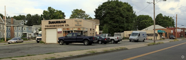
251 High St
WALT-000078-000003-000004
Middlesex
Storebuilding
Massachusetts
X
3
25017C0551F
0.13 AC
2025
Waltham
2025
Boston
368600
Boston-Cambridge-Newton, MA-NH
3,845 SF
DEMOGRAPHICS near 251 High St
1 Mile
3 Mile
5 Mile
2024 Total Population
28,556
147,846
357,362
2029 Population
28,157
145,710
351,347
Pop Growth 2024-2029
(1.40%)
(1.44%)
(1.68%)
Average Age
39
40
40
2024 Total Households
11,925
58,176
142,418
HH Growth 2024-2029
(1.46%)
(1.58%)
(1.91%)
Median Household Inc
$115,827
$123,729
$123,236
Avg Household Size
2.30
2.40
2.40
2024 Avg HH Vehicles
2.00
2.00
1.00
Median Home Value
$770,903
$850,032
$914,208
Median Year Built
1949
1949
1952
Nearby Places
Map Layers
Map Styles
 Street
 Aerial
- Restaurants
- Banks
- Shops
- Fitness
- Groceries
PUBLIC TRANSPORTATION
COMMUTER RAIL
Waltham (Fitchburg/South Acton Line - Massachusetts Bay Transportation Authority Commuter Rail (Purple Line))
DRIVE
WALK
Distance
Waltham (Fitchburg/South Acton Line - Massachusetts Bay Transportation Authority Commuter Rail (Purple Line))
6 min
1.2 mi
Newtonville (Framingham/Worcester Line - Massachusetts Bay Transportation Authority Commuter Rail (Purple Line))
DRIVE
WALK
Distance
Newtonville (Framingham/Worcester Line - Massachusetts Bay Transportation Authority Commuter Rail (Purple Line))
11 min
5.2 mi
AIRPORT
General Edward Lawrence Logan International
DRIVE
WALK
Distance
General Edward Lawrence Logan International
24 min
14.3 mi
Nearby Properties
Address
Land Use
TOTAL SIZE
Lot Size
Zoning
Address
Land Use
TOTAL SIZE
Lot Size
Zoning
447,312 SF
62.01 AC
Address
Land Use
TOTAL SIZE
Lot Size
Zoning
336,518 SF
6.15 AC
I-3
Address
Land Use
TOTAL SIZE
Lot Size
Zoning
220,671 SF
2.52 AC
I-2
Address
Land Use
TOTAL SIZE
Lot Size
Zoning
165,986 SF
4.32 AC
Address
Land Use
TOTAL SIZE
Lot Size
Zoning
176,625 SF
5.76 AC
I-3
Address
Land Use
TOTAL SIZE
Lot Size
Zoning
105,982 SF
4.50 AC
Address
Land Use
TOTAL SIZE
Lot Size
Zoning
30,170 SF
19 AC
SR2
Address
Land Use
TOTAL SIZE
Lot Size
Zoning
387,965 SF
3.90 AC
Address
Land Use
TOTAL SIZE
Lot Size
Zoning
21.52 AC
Address
Land Use
TOTAL SIZE
Lot Size
Zoning
317,256 SF
17.48 AC
Address
Land Use
TOTAL SIZE
Lot Size
Zoning
234,814 SF
4.06 AC
Address
Land Use
TOTAL SIZE
Lot Size
Zoning
293,084 SF
5.01 AC
1
Address
Land Use
TOTAL SIZE
Lot Size
Zoning
73.10 AC
SA
Address
Land Use
TOTAL SIZE
Lot Size
Zoning
238,065 SF
1.79 AC
Address
Land Use
TOTAL SIZE
Lot Size
Zoning
272,445 SF
6.40 AC
Address
Land Use
TOTAL SIZE
Lot Size
Zoning
179,834 SF
8.57 AC
PUB
Address
Land Use
TOTAL SIZE
Lot Size
Zoning
269,692 SF
15.37 AC
Address
Land Use
TOTAL SIZE
Lot Size
Zoning
402,419 SF
73.98 AC
BB
Address
Land Use
TOTAL SIZE
Lot Size
Zoning
6.51 AC
PSCD
Address
Land Use
TOTAL SIZE
Lot Size
Zoning
293,195 SF
11.55 AC
BU5
Address
Land Use
TOTAL SIZE
Lot Size
Zoning
391,781 SF
8.22 AC
Address
Land Use
TOTAL SIZE
Lot Size
Zoning
108,818 SF
I-1
Address
Land Use
TOTAL SIZE
Lot Size
Zoning
3.86 AC
Address
Land Use
TOTAL SIZE
Lot Size
Zoning
164,072 SF
43.80 AC
Address
Land Use
TOTAL SIZE
Lot Size
Zoning
30.69 AC
Address
Land Use
TOTAL SIZE
Lot Size
Zoning
145,572 SF
8.15 AC
OSC
Address
Land Use
TOTAL SIZE
Lot Size
Zoning
75.78 AC
SD
Address
Land Use
TOTAL SIZE
Lot Size
Zoning
21.99 AC
Address
Land Use
TOTAL SIZE
Lot Size
Zoning
124,950 SF
1.69 AC
Address
Land Use
TOTAL SIZE
Lot Size
Zoning
36,868 SF
3.41 AC
MAN
The World's #1 Commercial Real Estate Marketplace
Connect with us
© 2025 CoStar Group
The information above has been obtained from sources believed reliable. While we do not doubt its accuracy we have not verified it and make no guarantee, warranty or representation about it. It is your responsibility to independently confirm its accuracy and completeness. Any projections, opinions, assumptions, or estimates used are for example only and do not represent the current or future performance of the property. The value of this transaction to you depends on tax and other factors which should be evaluated by your tax, financial, and legal advisors. You and your advisors should conduct a careful, independent investigation of the property to determine to your satisfaction the suitability of the property for your needs.