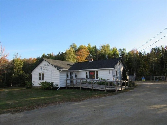
Property Record
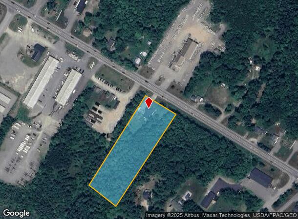
251 Main Rd, Holden, ME 04429

NEARBY LISTINGS FOR SALE OR LEASE
Property Detail
251 Main Rd
HOLN-000018-000000-000031
Penobscot
Commercialbuilding
Maine
X
31
23019C2139D
2.90 AC
2024
Other Market Areas
2024
Bangor, ME
009000
DEMOGRAPHICS near 251 Main Rd
1 Mile
3 Mile
5 Mile
2024 Total Population
833
7,137
37,287
2029 Population
855
7,259
38,126
Pop Growth 2024-2029
+ 2.64%
+ 1.71%
+ 2.25%
Average Age
46
45
43
2024 Total Households
360
3,024
17,138
HH Growth 2024-2029
+ 2.78%
+ 1.69%
+ 2.40%
Median Household Inc
$90,499
$66,781
$55,102
Avg Household Size
2.30
2.20
2.10
2024 Avg HH Vehicles
2.00
2.00
2.00
Median Home Value
$276,922
$231,718
$216,209
Median Year Built
1987
1976
1959
Nearby Places
Map Layers
Map Styles
 Street
 Aerial
- Restaurants
- Banks
- Shops
- Fitness
- Groceries
PUBLIC TRANSPORTATION
AIRPORT
Bangor International
DRIVE
WALK
Distance
Bangor International
16 min
9.3 mi
Freight Ports
Searsport, ME
DRIVE
WALK
Distance
Searsport, ME
51 min
30.2 mi
SALE & LEASE HISTORY
LISTING DATE
SALE/LEASE

Nov 13, 2017
For Sale
Nearby Properties
Address
Land Use
TOTAL SIZE
Lot Size
Zoning
Address
Land Use
TOTAL SIZE
Lot Size
Zoning
68,708 SF
7.85 AC
PB
Address
Land Use
TOTAL SIZE
Lot Size
Zoning
161,540 SF
23.68 AC
GB
Address
Land Use
TOTAL SIZE
Lot Size
Zoning
139,863 SF
20.68 AC
GB
Address
Land Use
TOTAL SIZE
Lot Size
Zoning
16.63 AC
GB
Address
Land Use
TOTAL SIZE
Lot Size
Zoning
1.48 AC
LDR
Address
Land Use
TOTAL SIZE
Lot Size
Zoning
25,400 SF
1 AC
PB
Address
Land Use
TOTAL SIZE
Lot Size
Zoning
23,347 SF
1 AC
PB
Address
Land Use
TOTAL SIZE
Lot Size
Zoning
28,685 SF
11.15 AC
PB
Address
Land Use
TOTAL SIZE
Lot Size
Zoning
28,244 SF
11.15 AC
PB
Address
Land Use
TOTAL SIZE
Lot Size
Zoning
12,432 SF
5.03 AC
GB
Address
Land Use
TOTAL SIZE
Lot Size
Zoning
32,700 SF
6.07 AC
GB
Address
Land Use
TOTAL SIZE
Lot Size
Zoning
9 AC
HDR-2
Address
Land Use
TOTAL SIZE
Lot Size
Zoning
1,935 SF
8.42 AC
GB
Address
Land Use
TOTAL SIZE
Lot Size
Zoning
8,563 SF
11.15 AC
PB
Address
Land Use
TOTAL SIZE
Lot Size
Zoning
18.17 AC
Address
Land Use
TOTAL SIZE
Lot Size
Zoning
87,500 SF
10.98 AC
GB
Address
Land Use
TOTAL SIZE
Lot Size
Zoning
20,258 SF
3.37 AC
GB
Address
Land Use
TOTAL SIZE
Lot Size
Zoning
54 AC
Address
Land Use
TOTAL SIZE
Lot Size
Zoning
8,797 SF
11.15 AC
PB
Address
Land Use
TOTAL SIZE
Lot Size
Zoning
5.41 AC
Address
Land Use
TOTAL SIZE
Lot Size
Zoning
27.90 AC
IND
Address
Land Use
TOTAL SIZE
Lot Size
Zoning
12,749 SF
11.15 AC
PB
Address
Land Use
TOTAL SIZE
Lot Size
Zoning
5.80 AC
IND
Address
Land Use
TOTAL SIZE
Lot Size
Zoning
34,576 SF
2.02 AC
GB
Address
Land Use
TOTAL SIZE
Lot Size
Zoning
0.21 AC
PB
Address
Land Use
TOTAL SIZE
Lot Size
Zoning
9,000 SF
1.90 AC
GB
Address
Land Use
TOTAL SIZE
Lot Size
Zoning
18,820 SF
12.70 AC
GB
Address
Land Use
TOTAL SIZE
Lot Size
Zoning
6,001 SF
1.36 AC
GB
Address
Land Use
TOTAL SIZE
Lot Size
Zoning
12.39 AC
HDR-2
Address
Land Use
TOTAL SIZE
Lot Size
Zoning
5,459 SF
1.51 AC
GB
The World's #1 Commercial Real Estate Marketplace
Connect with us
© 2025 CoStar Group
The information above has been obtained from sources believed reliable. While we do not doubt its accuracy we have not verified it and make no guarantee, warranty or representation about it. It is your responsibility to independently confirm its accuracy and completeness. Any projections, opinions, assumptions, or estimates used are for example only and do not represent the current or future performance of the property. The value of this transaction to you depends on tax and other factors which should be evaluated by your tax, financial, and legal advisors. You and your advisors should conduct a careful, independent investigation of the property to determine to your satisfaction the suitability of the property for your needs.