Property Record
251 S Atlantic Ave, Ormond Beach, FL 32176
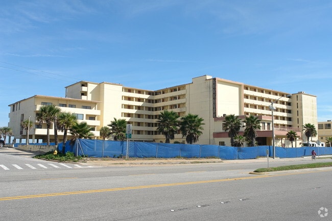

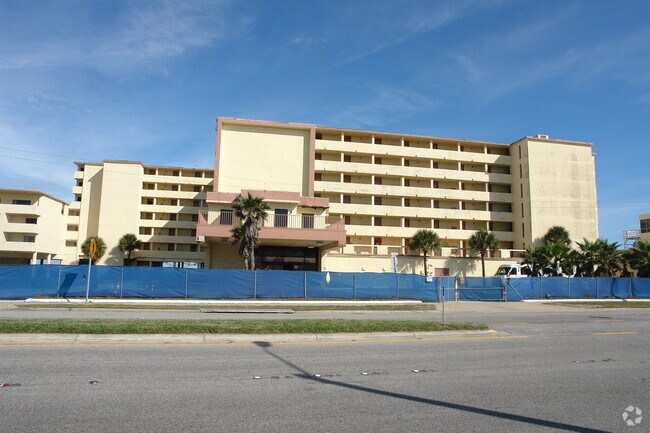
Property Detail
251 S Atlantic Ave
4214-19-07-0010
LOT 1 EXC ST & LOTS 2 THRU 5 BLK G ORMOND PKWY RESUB MB 8 PG 196 & N 100 FT OF S 368 FT OF LOT 18B E OF ATLANTIC AVE ASSRS ORMOND BEACH MB 3 PG 108 PER OR 4653 PGS 1503-1505 INC PER OR 5568 PGS 1119-1120 PER OR 6390 PG 2073 PER OR 6614 PG 1002 PER OR
Commercialacreage
VOLUSIA
13B6
Florida
VE and V1-30 Coastal areas with a 1% or greater chance of flooding and an additional hazard associated with storm waves. These areas have a 26% chance of flooding over the life of a 30-year mortgage.
1,2-5
2025
2.15 AC
2026
Daytona Beach
080500
Deltona/Daytona Beach
38,836 SF
Deltona-Daytona Beach-Ormond Beach, FL
NEARBY LISTINGS FOR SALE OR LEASE
DEMOGRAPHICS near 251 S Atlantic Ave
1 mile
3 mile
5 mile
2025 Total Population
4,047
34,299
93,947
2030 Population
4,444
37,253
101,703
Pop Growth 2025-2030
+ 9.81%
+ 8.61%
+ 8.26%
Average Age
50
48
46
2025 Total Households
2,034
16,234
42,621
HH Growth 2025-2030
+ 9.78%
+ 8.75%
+ 8.39%
Median Household Inc
$65,414
$58,054
$55,927
Avg Household Size
2.00
2.00
2.10
2025 Avg HH Vehicles
2.00
2.00
2.00
Median Home Value
$433,708
$361,959
$322,655
Median Year Built
1972
1974
1976
Nearby Places
Map Layers
Map Styles
 Street
 Aerial
Transit
 Traffic
 Biking
Places
Listings with unknown addresses are not visible on the map
- Restaurants
- Banks
- Shops
- Fitness
- Groceries
PUBLIC TRANSPORTATION
AIRPORT
Daytona Beach International
Drive
Walk
Distance
Daytona Beach International
25 min
11.4 mi
Nearby Properties
Address
Land Use
TOTAL SIZE
Lot Size
Zoning
Address
Land Use
TOTAL SIZE
Lot Size
Zoning
405,946 SF
2.79 AC
Address
Land Use
TOTAL SIZE
Lot Size
Zoning
300,760 SF
20.75 AC
Address
Land Use
TOTAL SIZE
Lot Size
Zoning
403,130 SF
28.45 AC
Address
Land Use
TOTAL SIZE
Lot Size
Zoning
16.50 AC
Address
Land Use
TOTAL SIZE
Lot Size
Zoning
Address
Land Use
TOTAL SIZE
Lot Size
Zoning
Address
Land Use
TOTAL SIZE
Lot Size
Zoning
102,495 SF
10.81 AC
02R2
Address
Land Use
TOTAL SIZE
Lot Size
Zoning
168,456 SF
15.74 AC
Address
Land Use
TOTAL SIZE
Lot Size
Zoning
144,576 SF
11.19 AC
13R6
Address
Land Use
TOTAL SIZE
Lot Size
Zoning
149,872 SF
20 AC
09R6
Address
Land Use
TOTAL SIZE
Lot Size
Zoning
179,868 SF
0.33 AC
Address
Land Use
TOTAL SIZE
Lot Size
Zoning
102,266 SF
2.20 AC
02T1
Address
Land Use
TOTAL SIZE
Lot Size
Zoning
Address
Land Use
TOTAL SIZE
Lot Size
Zoning
Address
Land Use
TOTAL SIZE
Lot Size
Zoning
135,886 SF
1.18 AC
Address
Land Use
TOTAL SIZE
Lot Size
Zoning
119,331 SF
9.09 AC
Address
Land Use
TOTAL SIZE
Lot Size
Zoning
96,309 SF
29.04 AC
Address
Land Use
TOTAL SIZE
Lot Size
Zoning
58,132 SF
1.50 AC
Address
Land Use
TOTAL SIZE
Lot Size
Zoning
125,088 SF
10.66 AC
B3
Address
Land Use
TOTAL SIZE
Lot Size
Zoning
Address
Land Use
TOTAL SIZE
Lot Size
Zoning
94,926 SF
3.85 AC
Address
Land Use
TOTAL SIZE
Lot Size
Zoning
208,503 SF
2.18 AC
02T1
Address
Land Use
TOTAL SIZE
Lot Size
Zoning
68,131 SF
5.53 AC
Address
Land Use
TOTAL SIZE
Lot Size
Zoning
102,345 SF
2.74 AC
Address
Land Use
TOTAL SIZE
Lot Size
Zoning
57,875 SF
1.95 AC
13B6
Address
Land Use
TOTAL SIZE
Lot Size
Zoning
Address
Land Use
TOTAL SIZE
Lot Size
Zoning
98,646 SF
6.88 AC
13B4
Address
Land Use
TOTAL SIZE
Lot Size
Zoning
Address
Land Use
TOTAL SIZE
Lot Size
Zoning
85,950 SF
8.24 AC
Address
Land Use
TOTAL SIZE
Lot Size
Zoning
66,896 SF
7.65 AC
B4
The World's #1 Commercial Real Estate Marketplace
Connect with us
© 2026 CoStar Group
The information above has been obtained from sources believed reliable. While we do not doubt its accuracy we have not verified it and make no guarantee, warranty or representation about it. It is your responsibility to independently confirm its accuracy and completeness. Any projections, opinions, assumptions, or estimates used are for example only and do not represent the current or future performance of the property. The value of this transaction to you depends on tax and other factors which should be evaluated by your tax, financial, and legal advisors. You and your advisors should conduct a careful, independent investigation of the property to determine to your satisfaction the suitability of the property for your needs.