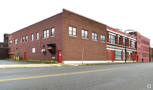
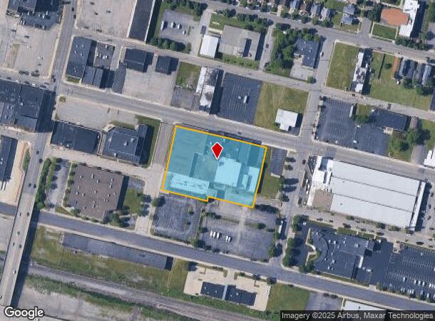
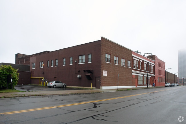
Property Record
251 Seneca St, Buffalo, NY 14204
NEARBY LISTINGS FOR SALE OR LEASE
Property Detail
251 Seneca St
140200-111-710-0005-020-100
115. W CHICAGO IRREG SOUTH LINE
Manufacturinglight
Erie
X
New York
36029C0213H
20.100
0
2.16 AC
2024
Greater Buffalo
016400
Buffalo/Niagara Falls
156,949 SF
Buffalo-Cheektowaga-Niagara Falls, NY
DEMOGRAPHICS near 251 Seneca St
1 Mile
3 Mile
5 Mile
2024 Total Population
13,416
100,752
250,478
2029 Population
13,690
99,115
244,412
Pop Growth 2024-2029
+ 2.04%
(1.62%)
(2.42%)
Average Age
40
38
38
2024 Total Households
6,806
46,295
109,146
HH Growth 2024-2029
+ 2.09%
(1.40%)
(2.38%)
Median Household Inc
$32,702
$38,306
$42,873
Avg Household Size
1.80
2.00
2.20
2024 Avg HH Vehicles
1.00
1.00
1.00
Median Home Value
$151,050
$149,873
$138,579
Median Year Built
1961
1947
1947
Nearby Places
- Restaurants
- Banks
- Shops
- Fitness
- Groceries
PUBLIC TRANSPORTATION
COMMUTER RAIL
DRIVE
WALK
Distance
2 min
8 min
0.4 mi
DRIVE
WALK
Distance
17 min
9.8 mi
AIRPORT
Buffalo Niagara International
DRIVE
WALK
Distance
Buffalo Niagara International
20 min
11.8 mi
Niagara Falls International
DRIVE
WALK
Distance
Niagara Falls International
32 min
21.0 mi
Nearby Properties
Address
Land Use
TOTAL SIZE
Lot Size
Zoning
Address
Land Use
TOTAL SIZE
Lot Size
Zoning
1,053,391 SF
88.26 AC
D-IL
Address
Land Use
TOTAL SIZE
Lot Size
Zoning
704,072 SF
8.61 AC
N-1C
Address
Land Use
TOTAL SIZE
Lot Size
Zoning
401,805 SF
2.04 AC
D-M
Address
Land Use
TOTAL SIZE
Lot Size
Zoning
166,250 SF
0.59 AC
D-M
Address
Land Use
TOTAL SIZE
Lot Size
Zoning
Address
Land Use
TOTAL SIZE
Lot Size
Zoning
151,371 SF
0.51 AC
D-M
Address
Land Use
TOTAL SIZE
Lot Size
Zoning
117,679 SF
0.41 AC
N-1C
Address
Land Use
TOTAL SIZE
Lot Size
Zoning
870,511 SF
4.40 AC
D-M
Address
Land Use
TOTAL SIZE
Lot Size
Zoning
686,000 SF
3.62 AC
N-2R
Address
Land Use
TOTAL SIZE
Lot Size
Zoning
240,783 SF
1.63 AC
N-1D
Address
Land Use
TOTAL SIZE
Lot Size
Zoning
288,014 SF
3.68 AC
N-1C
Address
Land Use
TOTAL SIZE
Lot Size
Zoning
658,732 SF
1.83 AC
N-1D
Address
Land Use
TOTAL SIZE
Lot Size
Zoning
251,908 SF
D-M
Address
Land Use
TOTAL SIZE
Lot Size
Zoning
86,825 SF
1.57 AC
D-M
Address
Land Use
TOTAL SIZE
Lot Size
Zoning
74,316 SF
0.25 AC
D-M
Address
Land Use
TOTAL SIZE
Lot Size
Zoning
569,121 SF
1.04 AC
N-1D
Address
Land Use
TOTAL SIZE
Lot Size
Zoning
896,000 SF
3.99 AC
N-1D
Address
Land Use
TOTAL SIZE
Lot Size
Zoning
66,655 SF
0.25 AC
D-M
Address
Land Use
TOTAL SIZE
Lot Size
Zoning
421,249 SF
10.62 AC
N-1D
Address
Land Use
TOTAL SIZE
Lot Size
Zoning
45,033 SF
1.18 AC
N-1C
Address
Land Use
TOTAL SIZE
Lot Size
Zoning
611,620 SF
2.20 AC
N-1S
Address
Land Use
TOTAL SIZE
Lot Size
Zoning
321,589 SF
1.95 AC
N-1C
Address
Land Use
TOTAL SIZE
Lot Size
Zoning
465,720 SF
1.98 AC
N-1D
Address
Land Use
TOTAL SIZE
Lot Size
Zoning
320,576 SF
1.90 AC
N-1S
Address
Land Use
TOTAL SIZE
Lot Size
Zoning
199,040 SF
2.24 AC
N-1D
Address
Land Use
TOTAL SIZE
Lot Size
Zoning
137,180 SF
4.28 AC
SPLIT ZONE
Address
Land Use
TOTAL SIZE
Lot Size
Zoning
156,870 SF
D-M
Address
Land Use
TOTAL SIZE
Lot Size
Zoning
372,216 SF
2.17 AC
N-1D
Address
Land Use
TOTAL SIZE
Lot Size
Zoning
473,220 SF
8.18 AC
N-1C
Address
Land Use
TOTAL SIZE
Lot Size
Zoning
217,888 SF
4.39 AC
N-1D
The World's #1 Commercial Real Estate Marketplace
Connect with us
© 2025 CoStar Group
The information above has been obtained from sources believed reliable. While we do not doubt its accuracy we have not verified it and make no guarantee, warranty or representation about it. It is your responsibility to independently confirm its accuracy and completeness. Any projections, opinions, assumptions, or estimates used are for example only and do not represent the current or future performance of the property. The value of this transaction to you depends on tax and other factors which should be evaluated by your tax, financial, and legal advisors. You and your advisors should conduct a careful, independent investigation of the property to determine to your satisfaction the suitability of the property for your needs.