Property Record
2510 S Providence Rd S, Waxhaw, NC 28173
NEARBY LISTINGS FOR SALE OR LEASE
Property Detail
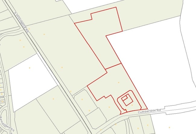
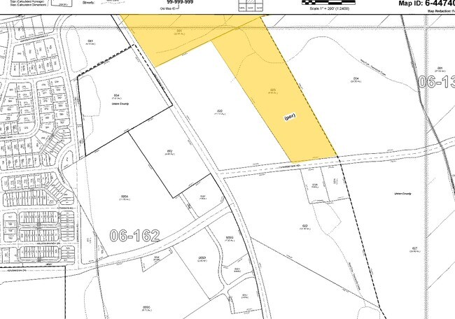
2510 S Providence Rd S
06-162-023
Final Plat Shoppes At Howards Mill Parce
Vehiclerentalsvehiclesales
PLAYER / OPCL007,OPCL190 PARCEL G OPCM488
X
Union
45057C0085E
North Carolina
2025
5.35 AC
2025
Union County
021013
Charlotte
41,356 SF
Charlotte-Concord-Gastonia, NC-SC
DEMOGRAPHICS near 2510 S Providence Rd S
1 Mile
3 Mile
5 Mile
2024 Total Population
4,582
36,425
77,826
2029 Population
5,093
41,277
88,643
Pop Growth 2024-2029
+ 11.15%
+ 13.32%
+ 13.90%
Average Age
37
37
38
2024 Total Households
1,365
11,162
24,580
HH Growth 2024-2029
+ 11.21%
+ 13.64%
+ 14.43%
Median Household Inc
$146,437
$132,617
$136,354
Avg Household Size
3.30
3.20
3.10
2024 Avg HH Vehicles
2.00
2.00
2.00
Median Home Value
$493,944
$452,844
$447,894
Median Year Built
2008
2009
2007
Nearby Places
Map Layers
Map Styles
 Street
 Aerial
- Restaurants
- Banks
- Shops
- Fitness
- Groceries
PUBLIC TRANSPORTATION
AIRPORT
Charlotte/Douglas International
DRIVE
WALK
Distance
Charlotte/Douglas International
39 min
25.6 mi
Concord-Padgett Regional
DRIVE
WALK
Distance
Concord-Padgett Regional
49 min
38.0 mi
Freight Ports
North Charleston Terminal
DRIVE
WALK
Distance
North Charleston Terminal
220 min
183.9 mi
Nearby Properties
Address
Land Use
TOTAL SIZE
Lot Size
Zoning
Address
Land Use
TOTAL SIZE
Lot Size
Zoning
223,642 SF
76.75 AC
R-40 UNION
Address
Land Use
TOTAL SIZE
Lot Size
Zoning
53,013 SF
9.32 AC
CD C-4 WAX
Address
Land Use
TOTAL SIZE
Lot Size
Zoning
170,725 SF
199.20 AC
R-40 UNION
Address
Land Use
TOTAL SIZE
Lot Size
Zoning
79,858 SF
28.88 AC
CU C-3 WAX
Address
Land Use
TOTAL SIZE
Lot Size
Zoning
93,098 SF
24.84 AC
CU R-4 PRD
Address
Land Use
TOTAL SIZE
Lot Size
Zoning
58,089 SF
10.22 AC
CU C-3 WAX
Address
Land Use
TOTAL SIZE
Lot Size
Zoning
42,420 SF
6.43 AC
TC WAXHAW
Address
Land Use
TOTAL SIZE
Lot Size
Zoning
93,098 SF
25.09 AC
R-40 UNION
Address
Land Use
TOTAL SIZE
Lot Size
Zoning
43,706 SF
10.37 AC
CU C-3 WAX
Address
Land Use
TOTAL SIZE
Lot Size
Zoning
141,212 SF
14.59 AC
CU C-3 WAX
Address
Land Use
TOTAL SIZE
Lot Size
Zoning
912 SF
17.37 AC
R-40 UNION
Address
Land Use
TOTAL SIZE
Lot Size
Zoning
57,625 SF
29.09 AC
CU C-2 WAX
Address
Land Use
TOTAL SIZE
Lot Size
Zoning
83,701 SF
33.12 AC
R-2 WAXHAW
Address
Land Use
TOTAL SIZE
Lot Size
Zoning
Address
Land Use
TOTAL SIZE
Lot Size
Zoning
32,704 SF
9.17 AC
C-3 WAXHAW
Address
Land Use
TOTAL SIZE
Lot Size
Zoning
32,450 SF
5.87 AC
R-40 UNION
Address
Land Use
TOTAL SIZE
Lot Size
Zoning
20,153 SF
25.25 AC
R-40 WESLE
Address
Land Use
TOTAL SIZE
Lot Size
Zoning
0.94 AC
RCD WEDDIN
Address
Land Use
TOTAL SIZE
Lot Size
Zoning
16,466 SF
35.06 AC
R-2 WAXHAW
Address
Land Use
TOTAL SIZE
Lot Size
Zoning
27,290 SF
2.64 AC
C-3 WAXHAW
Address
Land Use
TOTAL SIZE
Lot Size
Zoning
25,840 SF
2.64 AC
C-3 WAXHAW
Address
Land Use
TOTAL SIZE
Lot Size
Zoning
1,200 SF
113.16 AC
R-40 UNION
Address
Land Use
TOTAL SIZE
Lot Size
Zoning
6.10 AC
CU C-3 WAX
Address
Land Use
TOTAL SIZE
Lot Size
Zoning
16,477 SF
6.20 AC
B-4 UNION
Address
Land Use
TOTAL SIZE
Lot Size
Zoning
11.05 AC
Address
Land Use
TOTAL SIZE
Lot Size
Zoning
2.05 AC
CU C-2 WAX
Address
Land Use
TOTAL SIZE
Lot Size
Zoning
13,068 SF
1.78 AC
CU C-3 WAX
Address
Land Use
TOTAL SIZE
Lot Size
Zoning
14,838 SF
5.55 AC
C-3 WAXHAW
Address
Land Use
TOTAL SIZE
Lot Size
Zoning
0.88 AC
R-40 UNION
The World's #1 Commercial Real Estate Marketplace
Connect with us
© 2026 CoStar Group
The information above has been obtained from sources believed reliable. While we do not doubt its accuracy we have not verified it and make no guarantee, warranty or representation about it. It is your responsibility to independently confirm its accuracy and completeness. Any projections, opinions, assumptions, or estimates used are for example only and do not represent the current or future performance of the property. The value of this transaction to you depends on tax and other factors which should be evaluated by your tax, financial, and legal advisors. You and your advisors should conduct a careful, independent investigation of the property to determine to your satisfaction the suitability of the property for your needs.