Property Record
2510 Strunks Rd, Shakopee, MN 55379

Property Detail
2510 Strunks Rd
6-910-006-0
SECTION 10 TOWNSHIP 115 RANGE 023 SE1/4 SW1/4, NE1/4 SW1/4, SE1/4 NW1/4 S OF RR & 6A IN SE1/4 NW1/4 N OF RR
Manufacturinglight
Scott
I-1
Minnesota
AE The base floodplain where base flood elevations are provided. AE Zones are now used on new format FIRMs instead of A1-A30 Zones.
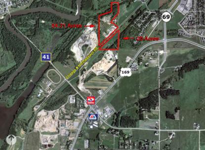
48.98 AC
2025
Scott County Outlying
2025
Minneapolis/St Paul
080700
Minneapolis-St. Paul-Bloomington, MN-WI
18,928 SF
NEARBY LISTINGS FOR SALE OR LEASE
DEMOGRAPHICS near 2510 Strunks Rd
1 mile
3 mile
5 mile
2025 Total Population
977
33,734
86,012
2030 Population
1,017
35,079
89,276
Pop Growth 2025-2030
+ 4.09%
+ 3.99%
+ 3.79%
Average Age
37
39
38
2025 Total Households
347
12,036
30,745
HH Growth 2025-2030
+ 4.03%
+ 4.04%
+ 3.94%
Median Household Inc
$63,482
$102,947
$111,611
Avg Household Size
2.80
2.70
2.70
2025 Avg HH Vehicles
2.00
2.00
2.00
Median Home Value
$99,999
$358,723
$401,209
Median Year Built
1987
1992
1997
Nearby Places
Map Layers
Map Styles
 Street
 Aerial
Layers
 Traffic
 Biking
Places
Listings with unknown addresses are not visible on the map
- Restaurants
- Banks
- Shops
- Fitness
- Groceries
PUBLIC TRANSPORTATION
AIRPORT
Minneapolis-St Paul International/Wold-Chamberlain
Drive
Walk
Distance
Minneapolis-St Paul International/Wold-Chamberlain
35 min
24.0 mi
Freight Ports
Port Milwaukee
Drive
Walk
Distance
Port Milwaukee
403 min
361.1 mi
Nearby Properties
Address
Land Use
TOTAL SIZE
Lot Size
Zoning
Address
Land Use
TOTAL SIZE
Lot Size
Zoning
625,426 SF
40.47 AC
Address
Land Use
TOTAL SIZE
Lot Size
Zoning
20,086 SF
12.99 AC
Address
Land Use
TOTAL SIZE
Lot Size
Zoning
Address
Land Use
TOTAL SIZE
Lot Size
Zoning
600,000 SF
31.21 AC
Address
Land Use
TOTAL SIZE
Lot Size
Zoning
44,611 SF
9.75 AC
Address
Land Use
TOTAL SIZE
Lot Size
Zoning
20,586 SF
19.34 AC
Address
Land Use
TOTAL SIZE
Lot Size
Zoning
51,272 SF
2.11 AC
Address
Land Use
TOTAL SIZE
Lot Size
Zoning
1.80 AC
Address
Land Use
TOTAL SIZE
Lot Size
Zoning
164,809 SF
7.28 AC
Address
Land Use
TOTAL SIZE
Lot Size
Zoning
198,754 SF
27.50 AC
Address
Land Use
TOTAL SIZE
Lot Size
Zoning
52,280 SF
12.15 AC
Address
Land Use
TOTAL SIZE
Lot Size
Zoning
57,769 SF
62.10 AC
Address
Land Use
TOTAL SIZE
Lot Size
Zoning
Address
Land Use
TOTAL SIZE
Lot Size
Zoning
26.05 AC
Address
Land Use
TOTAL SIZE
Lot Size
Zoning
191,395 SF
5.16 AC
Address
Land Use
TOTAL SIZE
Lot Size
Zoning
73,937 SF
23.89 AC
Address
Land Use
TOTAL SIZE
Lot Size
Zoning
65,038 SF
6.72 AC
Address
Land Use
TOTAL SIZE
Lot Size
Zoning
138,865 SF
12.55 AC
Address
Land Use
TOTAL SIZE
Lot Size
Zoning
131,154 SF
21.76 AC
Address
Land Use
TOTAL SIZE
Lot Size
Zoning
10,038 SF
12.21 AC
Address
Land Use
TOTAL SIZE
Lot Size
Zoning
93,297 SF
0.66 AC
Address
Land Use
TOTAL SIZE
Lot Size
Zoning
165,331 SF
2.62 AC
Address
Land Use
TOTAL SIZE
Lot Size
Zoning
20.79 AC
Address
Land Use
TOTAL SIZE
Lot Size
Zoning
33,982 SF
0.38 AC
Address
Land Use
TOTAL SIZE
Lot Size
Zoning
128,456 SF
15.85 AC
Address
Land Use
TOTAL SIZE
Lot Size
Zoning
61,267 SF
4.59 AC
Address
Land Use
TOTAL SIZE
Lot Size
Zoning
110,502 SF
13.27 AC
Address
Land Use
TOTAL SIZE
Lot Size
Zoning
30,052 SF
2.12 AC
Address
Land Use
TOTAL SIZE
Lot Size
Zoning
The World's #1 Commercial Real Estate Marketplace
Connect with us
© 2026 CoStar Group
The information above has been obtained from sources believed reliable. While we do not doubt its accuracy we have not verified it and make no guarantee, warranty or representation about it. It is your responsibility to independently confirm its accuracy and completeness. Any projections, opinions, assumptions, or estimates used are for example only and do not represent the current or future performance of the property. The value of this transaction to you depends on tax and other factors which should be evaluated by your tax, financial, and legal advisors. You and your advisors should conduct a careful, independent investigation of the property to determine to your satisfaction the suitability of the property for your needs.