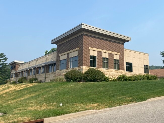
Property Record
2511 E Main St, Onalaska, WI 54650


NEARBY LISTINGS FOR SALE OR LEASE
Property Detail
2511 E Main St
La Crosse-Onalaska, WI-MN
CERTIFIED SURVEY MAP NO. 10 VOL 15 LOT 1 DOC NO. 1562766 SUBJ TO ESMT IN DOC NO. 1716105
018-004108-151
La Crosse
Commercialnec
Wisconsin
X
1
55063C0164D
0.97 AC
2024
La Crosse/Onalaska
2024
Other Market Areas
010401
DEMOGRAPHICS near 2511 E Main St
1 Mile
3 Mile
5 Mile
2024 Total Population
3,838
24,791
49,272
2029 Population
3,871
24,943
49,683
Pop Growth 2024-2029
+ 0.86%
+ 0.61%
+ 0.83%
Average Age
43
42
40
2024 Total Households
1,543
10,322
20,220
HH Growth 2024-2029
+ 0.78%
+ 0.40%
+ 0.73%
Median Household Inc
$80,332
$72,502
$59,842
Avg Household Size
2.40
2.30
2.30
2024 Avg HH Vehicles
2.00
2.00
2.00
Median Home Value
$276,130
$244,052
$229,048
Median Year Built
1985
1983
1979
Nearby Places
Map Layers
Map Styles
 Street
 Aerial
- Restaurants
- Banks
- Shops
- Fitness
- Groceries
PUBLIC TRANSPORTATION
COMMUTER RAIL
La Crosse (Empire Builder - Amtrak)
DRIVE
WALK
Distance
La Crosse (Empire Builder - Amtrak)
13 min
5.1 mi
AIRPORT
La Crosse Regional
DRIVE
WALK
Distance
La Crosse Regional
11 min
5.8 mi
Freight Ports
Port Milwaukee
DRIVE
WALK
Distance
Port Milwaukee
229 min
206.6 mi
SALE & LEASE HISTORY
LISTING DATE
SALE/LEASE

Jul 10, 2023
For Lease
Nearby Properties
Address
Land Use
TOTAL SIZE
Lot Size
Zoning
Address
Land Use
TOTAL SIZE
Lot Size
Zoning
45.53 AC
MZA
Address
Land Use
TOTAL SIZE
Lot Size
Zoning
42.20 AC
MZA
Address
Land Use
TOTAL SIZE
Lot Size
Zoning
12.60 AC
MZA
Address
Land Use
TOTAL SIZE
Lot Size
Zoning
6.91 AC
Address
Land Use
TOTAL SIZE
Lot Size
Zoning
7.68 AC
MZA
Address
Land Use
TOTAL SIZE
Lot Size
Zoning
14.59 AC
MZA
Address
Land Use
TOTAL SIZE
Lot Size
Zoning
11.40 AC
MZA
Address
Land Use
TOTAL SIZE
Lot Size
Zoning
29.80 AC
MZA
Address
Land Use
TOTAL SIZE
Lot Size
Zoning
12,500 SF
5.12 AC
MZA
Address
Land Use
TOTAL SIZE
Lot Size
Zoning
14.61 AC
MZA
Address
Land Use
TOTAL SIZE
Lot Size
Zoning
4.81 AC
Address
Land Use
TOTAL SIZE
Lot Size
Zoning
2.52 AC
Address
Land Use
TOTAL SIZE
Lot Size
Zoning
19.67 AC
MZA
Address
Land Use
TOTAL SIZE
Lot Size
Zoning
15.41 AC
MZA
Address
Land Use
TOTAL SIZE
Lot Size
Zoning
2.63 AC
MZA
Address
Land Use
TOTAL SIZE
Lot Size
Zoning
19.98 AC
Address
Land Use
TOTAL SIZE
Lot Size
Zoning
5.98 AC
MZA
Address
Land Use
TOTAL SIZE
Lot Size
Zoning
4.40 AC
Address
Land Use
TOTAL SIZE
Lot Size
Zoning
33.17 AC
MZA
Address
Land Use
TOTAL SIZE
Lot Size
Zoning
5.90 AC
Address
Land Use
TOTAL SIZE
Lot Size
Zoning
10.64 AC
MZA
Address
Land Use
TOTAL SIZE
Lot Size
Zoning
5.03 AC
Address
Land Use
TOTAL SIZE
Lot Size
Zoning
11.04 AC
MZA
Address
Land Use
TOTAL SIZE
Lot Size
Zoning
10.92 AC
MZA
Address
Land Use
TOTAL SIZE
Lot Size
Zoning
8.40 AC
MZA
Address
Land Use
TOTAL SIZE
Lot Size
Zoning
11.55 AC
Address
Land Use
TOTAL SIZE
Lot Size
Zoning
7.59 AC
MZA
Address
Land Use
TOTAL SIZE
Lot Size
Zoning
8.39 AC
MZA
Address
Land Use
TOTAL SIZE
Lot Size
Zoning
6.90 AC
MZA
Address
Land Use
TOTAL SIZE
Lot Size
Zoning
12.78 AC
The World's #1 Commercial Real Estate Marketplace
Connect with us
© 2026 CoStar Group
The information above has been obtained from sources believed reliable. While we do not doubt its accuracy we have not verified it and make no guarantee, warranty or representation about it. It is your responsibility to independently confirm its accuracy and completeness. Any projections, opinions, assumptions, or estimates used are for example only and do not represent the current or future performance of the property. The value of this transaction to you depends on tax and other factors which should be evaluated by your tax, financial, and legal advisors. You and your advisors should conduct a careful, independent investigation of the property to determine to your satisfaction the suitability of the property for your needs.