Property Record
2511 E Patrick Rd, Midland, MI 48642
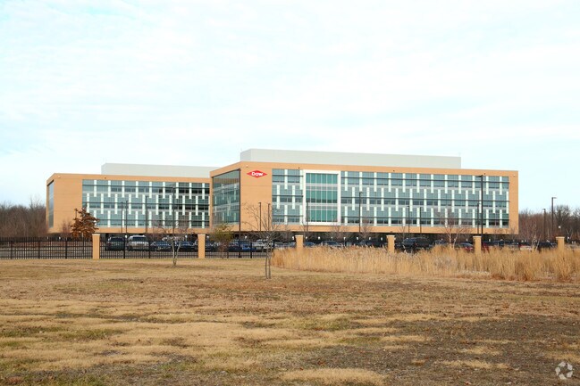

Property Detail
2511 E Patrick Rd
14-14-40-400
COM AT S 1/4 COR SEC 14, T14N-R2E, TH W 67.55 FT ALG S SEC LN, N 1264.05 FT, E 1510.46 FT, TH S 111 FT, S 35D 00M 00S E 359
Officebuilding
MIDLAND
LCMR
Michigan
B and X Area of moderate flood hazard, usually the area between the limits of the 100-year and 500-year floods.
47.21 AC
2024
Midland/Flint
2025
Other Market Areas
290902
Midland, MI
203,835 SF
NEARBY LISTINGS FOR SALE OR LEASE
DEMOGRAPHICS near 2511 E Patrick Rd
1 mile
3 mile
5 mile
2025 Total Population
6,319
30,474
46,880
2030 Population
6,471
30,522
46,914
Pop Growth 2025-2030
+ 2.41%
+ 0.16%
+ 0.07%
Average Age
39
41
42
2025 Total Households
2,850
13,206
19,651
HH Growth 2025-2030
+ 2.56%
+ 0.27%
+ 0.15%
Median Household Inc
$54,155
$65,631
$71,956
Avg Household Size
2.10
2.20
2.30
2025 Avg HH Vehicles
1.00
2.00
2.00
Median Home Value
$155,399
$175,297
$193,438
Median Year Built
1972
1967
1970
Nearby Places
Map Layers
Map Styles
 Street
 Aerial
Layers
 Traffic
 Biking
Places
Listings with unknown addresses are not visible on the map
- Restaurants
- Banks
- Shops
- Fitness
- Groceries
PUBLIC TRANSPORTATION
AIRPORT
MBS International
Drive
Walk
Distance
MBS International
20 min
11.0 mi
Nearby Properties
Address
Land Use
TOTAL SIZE
Lot Size
Zoning
Address
Land Use
TOTAL SIZE
Lot Size
Zoning
192,945 SF
15.02 AC
LCMR
Address
Land Use
TOTAL SIZE
Lot Size
Zoning
453,337 SF
52.33 AC
IA
Address
Land Use
TOTAL SIZE
Lot Size
Zoning
218,000 SF
5.02 AC
D
Address
Land Use
TOTAL SIZE
Lot Size
Zoning
1,586,189 SF
242.68 AC
IB
Address
Land Use
TOTAL SIZE
Lot Size
Zoning
58,714 SF
382.63 AC
COM
Address
Land Use
TOTAL SIZE
Lot Size
Zoning
Address
Land Use
TOTAL SIZE
Lot Size
Zoning
202,789 SF
139.19 AC
NC
Address
Land Use
TOTAL SIZE
Lot Size
Zoning
509,449 SF
14.19 AC
IB
Address
Land Use
TOTAL SIZE
Lot Size
Zoning
145,690 SF
1.69 AC
D
Address
Land Use
TOTAL SIZE
Lot Size
Zoning
49,903 SF
IB
Address
Land Use
TOTAL SIZE
Lot Size
Zoning
116,057 SF
120 AC
RA-1
Address
Land Use
TOTAL SIZE
Lot Size
Zoning
167,772 SF
20.87 AC
LCMR
Address
Land Use
TOTAL SIZE
Lot Size
Zoning
219,270 SF
20 AC
RB
Address
Land Use
TOTAL SIZE
Lot Size
Zoning
204,616 SF
5.74 AC
IB
Address
Land Use
TOTAL SIZE
Lot Size
Zoning
115,878 SF
7.53 AC
RB
Address
Land Use
TOTAL SIZE
Lot Size
Zoning
182,741 SF
6.41 AC
IB
Address
Land Use
TOTAL SIZE
Lot Size
Zoning
124,777 SF
9.54 AC
LCMR
Address
Land Use
TOTAL SIZE
Lot Size
Zoning
102,570 SF
7.50 AC
IB
Address
Land Use
TOTAL SIZE
Lot Size
Zoning
195,793 SF
5.79 AC
IB
Address
Land Use
TOTAL SIZE
Lot Size
Zoning
108,135 SF
13.62 AC
IB
Address
Land Use
TOTAL SIZE
Lot Size
Zoning
52,574 SF
5.15 AC
IA
Address
Land Use
TOTAL SIZE
Lot Size
Zoning
76,333 SF
10.01 AC
RB
Address
Land Use
TOTAL SIZE
Lot Size
Zoning
2,800 SF
8.52 AC
IB
Address
Land Use
TOTAL SIZE
Lot Size
Zoning
198,890 SF
10.26 AC
IB
Address
Land Use
TOTAL SIZE
Lot Size
Zoning
126,335 SF
11.79 AC
RC
Address
Land Use
TOTAL SIZE
Lot Size
Zoning
11.91 AC
Address
Land Use
TOTAL SIZE
Lot Size
Zoning
104,714 SF
6.53 AC
IB
Address
Land Use
TOTAL SIZE
Lot Size
Zoning
156,832 SF
8.32 AC
IA
Address
Land Use
TOTAL SIZE
Lot Size
Zoning
55,926 SF
1.72 AC
CC
The World's #1 Commercial Real Estate Marketplace
Connect with us
© 2026 CoStar Group
The information above has been obtained from sources believed reliable. While we do not doubt its accuracy we have not verified it and make no guarantee, warranty or representation about it. It is your responsibility to independently confirm its accuracy and completeness. Any projections, opinions, assumptions, or estimates used are for example only and do not represent the current or future performance of the property. The value of this transaction to you depends on tax and other factors which should be evaluated by your tax, financial, and legal advisors. You and your advisors should conduct a careful, independent investigation of the property to determine to your satisfaction the suitability of the property for your needs.