Property Record
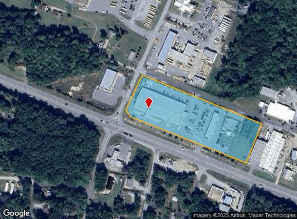
2511 E Us Highway 64, Lexington, NC 27292
NEARBY LISTINGS FOR SALE OR LEASE
-
-
View all Lexington listings for sale on LoopNet.com
Property Detail
2511 E Us Highway 64
05-005-A-00D-0001-0-0-0
Marion Heights Property
Countyproperty
P=10-22 BD L1-34&60-93 BK2042-52
X
Davidson
3710674500J
North Carolina
0
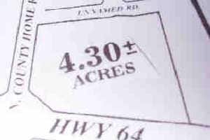
5.82 AC
2025
South Davidson County
061904
Greensboro/Winston-Salem
45,732 SF
Winston-Salem, NC
DEMOGRAPHICS near 2511 E Us Highway 64
1 Mile
3 Mile
5 Mile
2024 Total Population
1,108
10,994
36,303
2029 Population
1,154
11,601
38,470
Pop Growth 2024-2029
+ 4.15%
+ 5.52%
+ 5.97%
Average Age
44
41
41
2024 Total Households
479
4,398
14,620
HH Growth 2024-2029
+ 3.97%
+ 5.46%
+ 5.89%
Median Household Inc
$51,364
$38,728
$38,249
Avg Household Size
2.30
2.30
2.40
2024 Avg HH Vehicles
2.00
2.00
2.00
Median Home Value
$150,000
$166,811
$149,811
Median Year Built
1982
1975
1977
Nearby Places
Map Layers
Map Styles
 Street
 Aerial
- Restaurants
- Banks
- Shops
- Fitness
- Groceries
PUBLIC TRANSPORTATION
AIRPORT
Piedmont Triad International
DRIVE
WALK
Distance
Piedmont Triad International
47 min
36.3 mi
Freight Ports
Port of Wilmington
DRIVE
WALK
Distance
Port of Wilmington
252 min
209.8 mi
Nearby Properties
Address
Land Use
TOTAL SIZE
Lot Size
Zoning
Address
Land Use
TOTAL SIZE
Lot Size
Zoning
4,788 SF
11.95 AC
HC
Address
Land Use
TOTAL SIZE
Lot Size
Zoning
20,651 SF
12.03 AC
B
Address
Land Use
TOTAL SIZE
Lot Size
Zoning
33,282 SF
4.41 AC
B
Address
Land Use
TOTAL SIZE
Lot Size
Zoning
84,523 SF
26.56 AC
RA1
Address
Land Use
TOTAL SIZE
Lot Size
Zoning
8,008 SF
9.26 AC
TN
Address
Land Use
TOTAL SIZE
Lot Size
Zoning
202.55 AC
LICZ
Address
Land Use
TOTAL SIZE
Lot Size
Zoning
128 SF
107.80 AC
PD
Address
Land Use
TOTAL SIZE
Lot Size
Zoning
115,600 SF
13.15 AC
I
Address
Land Use
TOTAL SIZE
Lot Size
Zoning
2,414 SF
16.14 AC
TN
Address
Land Use
TOTAL SIZE
Lot Size
Zoning
91,758 SF
12.07 AC
B
Address
Land Use
TOTAL SIZE
Lot Size
Zoning
135,603 SF
3.76 AC
TN
Address
Land Use
TOTAL SIZE
Lot Size
Zoning
41,784 SF
12.77 AC
OI
Address
Land Use
TOTAL SIZE
Lot Size
Zoning
14,648 SF
15.93 AC
OI
Address
Land Use
TOTAL SIZE
Lot Size
Zoning
9,054 SF
24.77 AC
TN
Address
Land Use
TOTAL SIZE
Lot Size
Zoning
7,080 SF
364.78 AC
RA3
Address
Land Use
TOTAL SIZE
Lot Size
Zoning
9,248 SF
14.71 AC
RM2
Address
Land Use
TOTAL SIZE
Lot Size
Zoning
22,415 SF
5 AC
B
Address
Land Use
TOTAL SIZE
Lot Size
Zoning
15,532 SF
0.67 AC
U
Address
Land Use
TOTAL SIZE
Lot Size
Zoning
29,782 SF
3.06 AC
B
Address
Land Use
TOTAL SIZE
Lot Size
Zoning
34,372 SF
4.17 AC
B
Address
Land Use
TOTAL SIZE
Lot Size
Zoning
32,562 SF
2.78 AC
B
Address
Land Use
TOTAL SIZE
Lot Size
Zoning
15,527 SF
3.03 AC
HC
Address
Land Use
TOTAL SIZE
Lot Size
Zoning
27,736 SF
2.84 AC
OI
Address
Land Use
TOTAL SIZE
Lot Size
Zoning
37.83 AC
CS
Address
Land Use
TOTAL SIZE
Lot Size
Zoning
9,949 SF
7.37 AC
B
Address
Land Use
TOTAL SIZE
Lot Size
Zoning
10,400 SF
0.97 AC
U
Address
Land Use
TOTAL SIZE
Lot Size
Zoning
56,986 SF
3.41 AC
B
Address
Land Use
TOTAL SIZE
Lot Size
Zoning
12,541 SF
0.92 AC
MU
Address
Land Use
TOTAL SIZE
Lot Size
Zoning
49,198 SF
4.55 AC
B
The World's #1 Commercial Real Estate Marketplace
Connect with us
© 2025 CoStar Group
The information above has been obtained from sources believed reliable. While we do not doubt its accuracy we have not verified it and make no guarantee, warranty or representation about it. It is your responsibility to independently confirm its accuracy and completeness. Any projections, opinions, assumptions, or estimates used are for example only and do not represent the current or future performance of the property. The value of this transaction to you depends on tax and other factors which should be evaluated by your tax, financial, and legal advisors. You and your advisors should conduct a careful, independent investigation of the property to determine to your satisfaction the suitability of the property for your needs.