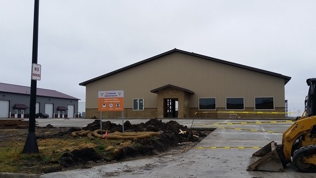
Property Record
2512 Main Ave W, West Fargo, ND 58078

NEARBY LISTINGS FOR SALE OR LEASE
-
-
No Photo
-
View all West Fargo listings for sale on LoopNet.com
Property Detail
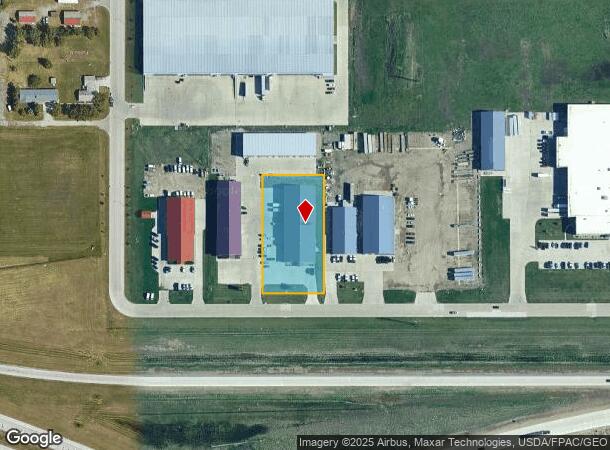
2512 Main Ave W
Fargo, ND-MN
Knutsons First Subdivision
02-0952-00020-000
LOT: 2 BLOCK: 1 ADDITION: KNUTSON'S 3RD ADDITION ADDITIONAL: KNUTSON'S 3RD ADDN LT 2 BLK 1 **3-1-16 REPLATTED FRM 02-0950-00030-000, 02-0950-00040-000 & 02-0950-00050-000
Realpropertynec
Cass
X
North Dakota
38017C0565G
2
2024
1.19 AC
2024
Fargo
010201
Other Market Areas
16,000 SF
DEMOGRAPHICS near 2512 Main Ave W
1 Mile
3 Mile
5 Mile
2024 Total Population
92
16,242
58,837
2029 Population
99
17,450
63,257
Pop Growth 2024-2029
+ 7.61%
+ 7.44%
+ 7.51%
Average Age
35
38
35
2024 Total Households
36
6,730
25,174
HH Growth 2024-2029
+ 8.33%
+ 7.88%
+ 7.97%
Median Household Inc
$71,785
$75,671
$72,581
Avg Household Size
2.40
2.40
2.30
2024 Avg HH Vehicles
2.00
2.00
2.00
Median Home Value
$250,000
$243,457
$268,237
Median Year Built
1995
1992
2003
Nearby Places
Map Layers
Map Styles
 Street
 Aerial
- Restaurants
- Banks
- Shops
- Fitness
- Groceries
PUBLIC TRANSPORTATION
COMMUTER RAIL
DRIVE
WALK
Distance
17 min
8.4 mi
AIRPORT
Hector International
DRIVE
WALK
Distance
Hector International
21 min
10.8 mi
SALE & LEASE HISTORY
LISTING DATE
SALE/LEASE

Sep 25, 2016
For Lease
Jun 18, 2024
For Sale
Nearby Properties
Address
Land Use
TOTAL SIZE
Lot Size
Zoning
Address
Land Use
TOTAL SIZE
Lot Size
Zoning
15,895 SF
41.76 AC
Address
Land Use
TOTAL SIZE
Lot Size
Zoning
99,300 SF
12.72 AC
Address
Land Use
TOTAL SIZE
Lot Size
Zoning
79,310 SF
17.79 AC
Address
Land Use
TOTAL SIZE
Lot Size
Zoning
354,677 SF
13.13 AC
Address
Land Use
TOTAL SIZE
Lot Size
Zoning
156,450 SF
14.92 AC
Address
Land Use
TOTAL SIZE
Lot Size
Zoning
240,766 SF
15.14 AC
Address
Land Use
TOTAL SIZE
Lot Size
Zoning
131,360 SF
4.52 AC
Address
Land Use
TOTAL SIZE
Lot Size
Zoning
Address
Land Use
TOTAL SIZE
Lot Size
Zoning
180,000 SF
10.73 AC
Address
Land Use
TOTAL SIZE
Lot Size
Zoning
13,970 SF
32.10 AC
Address
Land Use
TOTAL SIZE
Lot Size
Zoning
16.39 AC
Address
Land Use
TOTAL SIZE
Lot Size
Zoning
193,114 SF
9.96 AC
Address
Land Use
TOTAL SIZE
Lot Size
Zoning
70,800 SF
9.18 AC
Address
Land Use
TOTAL SIZE
Lot Size
Zoning
60,947 SF
4.48 AC
Address
Land Use
TOTAL SIZE
Lot Size
Zoning
Address
Land Use
TOTAL SIZE
Lot Size
Zoning
102,000 SF
4.96 AC
Address
Land Use
TOTAL SIZE
Lot Size
Zoning
60,320 SF
1.15 AC
Address
Land Use
TOTAL SIZE
Lot Size
Zoning
28,107 SF
6.19 AC
Address
Land Use
TOTAL SIZE
Lot Size
Zoning
23,900 SF
19.41 AC
Address
Land Use
TOTAL SIZE
Lot Size
Zoning
8,256 SF
9.09 AC
Address
Land Use
TOTAL SIZE
Lot Size
Zoning
Address
Land Use
TOTAL SIZE
Lot Size
Zoning
50,400 SF
10.74 AC
Address
Land Use
TOTAL SIZE
Lot Size
Zoning
17.40 AC
Address
Land Use
TOTAL SIZE
Lot Size
Zoning
Address
Land Use
TOTAL SIZE
Lot Size
Zoning
5,940 SF
10.41 AC
Address
Land Use
TOTAL SIZE
Lot Size
Zoning
27,163 SF
9.30 AC
Address
Land Use
TOTAL SIZE
Lot Size
Zoning
4,694 SF
12.43 AC
Address
Land Use
TOTAL SIZE
Lot Size
Zoning
50,820 SF
11.18 AC
Address
Land Use
TOTAL SIZE
Lot Size
Zoning
12,163 SF
1.80 AC
Address
Land Use
TOTAL SIZE
Lot Size
Zoning
22,800 SF
3.81 AC
The World's #1 Commercial Real Estate Marketplace
Connect with us
© 2026 CoStar Group
The information above has been obtained from sources believed reliable. While we do not doubt its accuracy we have not verified it and make no guarantee, warranty or representation about it. It is your responsibility to independently confirm its accuracy and completeness. Any projections, opinions, assumptions, or estimates used are for example only and do not represent the current or future performance of the property. The value of this transaction to you depends on tax and other factors which should be evaluated by your tax, financial, and legal advisors. You and your advisors should conduct a careful, independent investigation of the property to determine to your satisfaction the suitability of the property for your needs.