Property Record
2512 State Highway 66, Estes Park, CO 80517
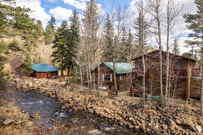

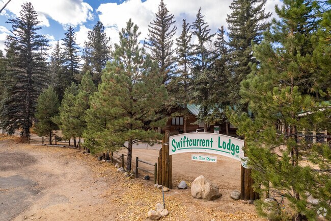

Property Detail
2512 State Highway 66
34041-00-019
BEG AT NE COR 4-4-73, S 76 4 W 1505.6 FT TO C/L MORAINE PK RD, TH ALG C/L S 52 52 W 207.3 FT TPOB, TH ALG C/L OLD WIND RIV RD S 28 5 W 85 FT, S 3 52 E 70 FT, S 29 3 E 89.6 FT TO W R/W E PORTAL RD, TH ALG R/W SD RD S 23 52 W 64.8 FT M/L TO CEN BIG T
Transientlodging
Larimer
A
Colorado
AE The base floodplain where base flood elevations are provided. AE Zones are now used on new format FIRMs instead of A1-A30 Zones.
3
2024
0.83 AC
2025
Loveland Area
002805
Denver
5,567 SF
Fort Collins-Loveland, CO
NEARBY LISTINGS FOR SALE OR LEASE
DEMOGRAPHICS near 2512 State Highway 66
1 mile
3 mile
5 mile
2025 Total Population
316
4,439
12,631
2030 Population
341
4,867
13,781
Pop Growth 2025-2030
+ 7.91%
+ 9.64%
+ 9.10%
Average Age
48
50
50
2025 Total Households
136
2,073
5,745
HH Growth 2025-2030
+ 8.82%
+ 10.08%
+ 9.42%
Median Household Inc
$64,583
$73,215
$75,096
Avg Household Size
2.10
2.00
2.10
2025 Avg HH Vehicles
3.00
2.00
2.00
Median Home Value
$617,647
$752,870
$755,718
Median Year Built
1971
1978
1985
Nearby Places
Map Layers
Map Styles
 Street
 Aerial
Transit
 Traffic
 Biking
Places
Listings with unknown addresses are not visible on the map
- Restaurants
- Banks
- Shops
- Fitness
- Groceries
SALE & LEASE HISTORY
LISTING DATE
SALE/LEASE

Jul 27, 2019
For Sale
Nearby Properties
Address
Land Use
TOTAL SIZE
Lot Size
Zoning
Address
Land Use
TOTAL SIZE
Lot Size
Zoning
793,190 SF
587.03 AC
A
Address
Land Use
TOTAL SIZE
Lot Size
Zoning
38,222 SF
3.53 AC
Address
Land Use
TOTAL SIZE
Lot Size
Zoning
45,229 SF
3.80 AC
Address
Land Use
TOTAL SIZE
Lot Size
Zoning
46,243 SF
43.03 AC
A
Address
Land Use
TOTAL SIZE
Lot Size
Zoning
17,933 SF
2.58 AC
Address
Land Use
TOTAL SIZE
Lot Size
Zoning
22,487 SF
80.70 AC
A
Address
Land Use
TOTAL SIZE
Lot Size
Zoning
27,198 SF
6 AC
RE
Address
Land Use
TOTAL SIZE
Lot Size
Zoning
61,320 SF
5.87 AC
Address
Land Use
TOTAL SIZE
Lot Size
Zoning
21,351 SF
28.90 AC
Address
Land Use
TOTAL SIZE
Lot Size
Zoning
23,362 SF
5.54 AC
Address
Land Use
TOTAL SIZE
Lot Size
Zoning
16,838 SF
1.64 AC
Address
Land Use
TOTAL SIZE
Lot Size
Zoning
5,747 SF
12 AC
A
Address
Land Use
TOTAL SIZE
Lot Size
Zoning
12,826 SF
5.75 AC
Address
Land Use
TOTAL SIZE
Lot Size
Zoning
9,510 SF
30.68 AC
T
Address
Land Use
TOTAL SIZE
Lot Size
Zoning
16,836 SF
3 AC
Address
Land Use
TOTAL SIZE
Lot Size
Zoning
14,686 SF
5.06 AC
Address
Land Use
TOTAL SIZE
Lot Size
Zoning
15,217 SF
13.61 AC
A
Address
Land Use
TOTAL SIZE
Lot Size
Zoning
17,920 SF
1.32 AC
A
Address
Land Use
TOTAL SIZE
Lot Size
Zoning
15,383 SF
11.26 AC
A1
Address
Land Use
TOTAL SIZE
Lot Size
Zoning
11,517 SF
8.55 AC
Address
Land Use
TOTAL SIZE
Lot Size
Zoning
10,595 SF
6.88 AC
Address
Land Use
TOTAL SIZE
Lot Size
Zoning
16,838 SF
1.64 AC
Address
Land Use
TOTAL SIZE
Lot Size
Zoning
13,078 SF
3 AC
Address
Land Use
TOTAL SIZE
Lot Size
Zoning
13,582 SF
1.40 AC
Address
Land Use
TOTAL SIZE
Lot Size
Zoning
1,469 SF
10.53 AC
Address
Land Use
TOTAL SIZE
Lot Size
Zoning
1,800 SF
40 AC
RE
Address
Land Use
TOTAL SIZE
Lot Size
Zoning
6,350 SF
0.23 AC
Address
Land Use
TOTAL SIZE
Lot Size
Zoning
19,744 SF
0.28 AC
Address
Land Use
TOTAL SIZE
Lot Size
Zoning
9,111 SF
4 AC
A
Address
Land Use
TOTAL SIZE
Lot Size
Zoning
20,402 SF
1.65 AC
The World's #1 Commercial Real Estate Marketplace
Connect with us
© 2026 CoStar Group
The information above has been obtained from sources believed reliable. While we do not doubt its accuracy we have not verified it and make no guarantee, warranty or representation about it. It is your responsibility to independently confirm its accuracy and completeness. Any projections, opinions, assumptions, or estimates used are for example only and do not represent the current or future performance of the property. The value of this transaction to you depends on tax and other factors which should be evaluated by your tax, financial, and legal advisors. You and your advisors should conduct a careful, independent investigation of the property to determine to your satisfaction the suitability of the property for your needs.