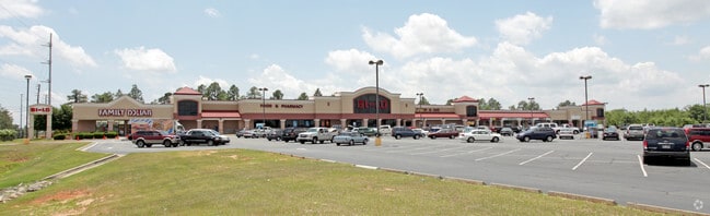
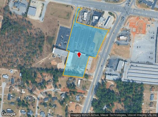
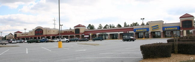
Property Record
2512 Tobacco Rd, Hephzibah, GA 30815
NEARBY LISTINGS FOR SALE OR LEASE
Property Detail
2512 Tobacco Rd
Augusta-Richmond County, GA-SC
No Sub Code Sec Tra
1530580000
NO SUB CODE (TRA00) 00A-0
Commercialacreage
Richmond
X
Georgia
13245C0205G
a
2025
5.46 AC
2025
South Richmond County
010713
Augusta/Richmond County
48,152 SF
DEMOGRAPHICS near 2512 Tobacco Rd
1 Mile
3 Mile
5 Mile
2024 Total Population
5,358
41,698
85,545
2029 Population
5,289
41,093
84,708
Pop Growth 2024-2029
(1.29%)
(1.45%)
(0.98%)
Average Age
39
38
37
2024 Total Households
1,976
15,247
29,374
HH Growth 2024-2029
(1.21%)
(1.34%)
(0.99%)
Median Household Inc
$57,146
$54,074
$48,465
Avg Household Size
2.60
2.70
2.60
2024 Avg HH Vehicles
2.00
2.00
2.00
Median Home Value
$135,049
$134,701
$118,097
Median Year Built
1987
1986
1980
Nearby Places
Map Layers
Map Styles
 Street
 Aerial
- Restaurants
- Banks
- Shops
- Fitness
- Groceries
PUBLIC TRANSPORTATION
AIRPORT
Augusta Regional at Bush Field
DRIVE
WALK
Distance
Augusta Regional at Bush Field
19 min
8.6 mi
Freight Ports
Georgia Ports - Savannah
DRIVE
WALK
Distance
Georgia Ports - Savannah
147 min
114.4 mi
Nearby Properties
Address
Land Use
TOTAL SIZE
Lot Size
Zoning
Address
Land Use
TOTAL SIZE
Lot Size
Zoning
99,046 SF
29.96 AC
R-1A
Address
Land Use
TOTAL SIZE
Lot Size
Zoning
87,976 SF
765.88 AC
R-1
Address
Land Use
TOTAL SIZE
Lot Size
Zoning
59,310 SF
43.16 AC
A
Address
Land Use
TOTAL SIZE
Lot Size
Zoning
252,567 SF
27.65 AC
B-2
Address
Land Use
TOTAL SIZE
Lot Size
Zoning
252,567 SF
18.59 AC
R-3B
Address
Land Use
TOTAL SIZE
Lot Size
Zoning
3,387 SF
16.91 AC
B-2
Address
Land Use
TOTAL SIZE
Lot Size
Zoning
4,196 SF
30.70 AC
R-3A
Address
Land Use
TOTAL SIZE
Lot Size
Zoning
18,000 SF
27.80 AC
B-2
Address
Land Use
TOTAL SIZE
Lot Size
Zoning
94,579 SF
60.10 AC
R-1
Address
Land Use
TOTAL SIZE
Lot Size
Zoning
1,080 SF
18.87 AC
R-3B
Address
Land Use
TOTAL SIZE
Lot Size
Zoning
41,664 SF
12.52 AC
R-3A
Address
Land Use
TOTAL SIZE
Lot Size
Zoning
22,080 SF
19.49 AC
R-3B
Address
Land Use
TOTAL SIZE
Lot Size
Zoning
17,192 SF
12.84 AC
A_R-1 SPEX
Address
Land Use
TOTAL SIZE
Lot Size
Zoning
80,453 SF
23.92 AC
R-1B
Address
Land Use
TOTAL SIZE
Lot Size
Zoning
80,038 SF
19.49 AC
R-1A
Address
Land Use
TOTAL SIZE
Lot Size
Zoning
17,202 SF
28.86 AC
B-1
Address
Land Use
TOTAL SIZE
Lot Size
Zoning
1,936 SF
13.39 AC
B-1
Address
Land Use
TOTAL SIZE
Lot Size
Zoning
78,454 SF
10.63 AC
B-2
Address
Land Use
TOTAL SIZE
Lot Size
Zoning
67,560 SF
15.97 AC
R-1
Address
Land Use
TOTAL SIZE
Lot Size
Zoning
107,996 SF
9.91 AC
R-3B
Address
Land Use
TOTAL SIZE
Lot Size
Zoning
7,800 SF
4.68 AC
B-2
Address
Land Use
TOTAL SIZE
Lot Size
Zoning
961 SF
5.15 AC
B-2
Address
Land Use
TOTAL SIZE
Lot Size
Zoning
19,771 SF
23 AC
A
Address
Land Use
TOTAL SIZE
Lot Size
Zoning
1,800 SF
4.30 AC
B-2
Address
Land Use
TOTAL SIZE
Lot Size
Zoning
48,175 SF
6.55 AC
B-2
Address
Land Use
TOTAL SIZE
Lot Size
Zoning
2,356 SF
122.32 AC
A_R-MH
Address
Land Use
TOTAL SIZE
Lot Size
Zoning
56,038 SF
8.01 AC
B-2
Address
Land Use
TOTAL SIZE
Lot Size
Zoning
61,880 SF
4.56 AC
R-3B
Address
Land Use
TOTAL SIZE
Lot Size
Zoning
23,152 SF
9.49 AC
A_B-2
Address
Land Use
TOTAL SIZE
Lot Size
Zoning
11,013 SF
43.41 AC
R-3B SPEX
The World's #1 Commercial Real Estate Marketplace
Connect with us
© 2026 CoStar Group
The information above has been obtained from sources believed reliable. While we do not doubt its accuracy we have not verified it and make no guarantee, warranty or representation about it. It is your responsibility to independently confirm its accuracy and completeness. Any projections, opinions, assumptions, or estimates used are for example only and do not represent the current or future performance of the property. The value of this transaction to you depends on tax and other factors which should be evaluated by your tax, financial, and legal advisors. You and your advisors should conduct a careful, independent investigation of the property to determine to your satisfaction the suitability of the property for your needs.