Property Record
2515 Robert Hardeman Rd, Winterville, GA 30683
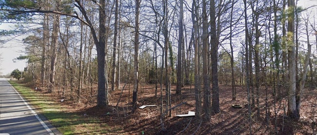
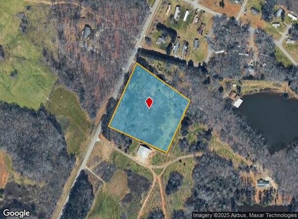
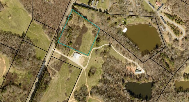
This Property Is For Sale
NEARBY LISTINGS FOR SALE OR LEASE
Property Detail
2515 Robert Hardeman Rd
Athens-Clarke County, GA
Com-St-020->03-06
293-015-B
TRACT 3 - 4.097 AC - PB G/4B & 4I
Residentialacreage
Clarke
X
Georgia
13221C0125C
4.10 AC
2025
East Athens
2025
Other Market Areas
150900
DEMOGRAPHICS near 2515 Robert Hardeman Rd
1 Mile
3 Mile
5 Mile
2024 Total Population
589
13,403
38,884
2029 Population
601
13,344
38,957
Pop Growth 2024-2029
+ 2.04%
(0.44%)
+ 0.19%
Average Age
45
41
38
2024 Total Households
225
5,445
16,557
HH Growth 2024-2029
+ 2.22%
(0.39%)
+ 0.18%
Median Household Inc
$75,500
$70,949
$61,021
Avg Household Size
2.40
2.40
2.30
2024 Avg HH Vehicles
2.00
2.00
2.00
Median Home Value
$436,956
$323,477
$292,685
Median Year Built
1991
1986
1989
Nearby Places
- Restaurants
- Banks
- Shops
- Fitness
- Groceries
Nearby Properties
Address
Land Use
TOTAL SIZE
Lot Size
Zoning
Address
Land Use
TOTAL SIZE
Lot Size
Zoning
986 SF
40.54 AC
RM-1
Address
Land Use
TOTAL SIZE
Lot Size
Zoning
11,700 SF
12.05 AC
RM-2
Address
Land Use
TOTAL SIZE
Lot Size
Zoning
28.89 AC
G
Address
Land Use
TOTAL SIZE
Lot Size
Zoning
77,569 SF
12.18 AC
C-G
Address
Land Use
TOTAL SIZE
Lot Size
Zoning
205,548 SF
22.68 AC
C-G(PD)
Address
Land Use
TOTAL SIZE
Lot Size
Zoning
9,588 SF
12.69 AC
RM-1
Address
Land Use
TOTAL SIZE
Lot Size
Zoning
445 AC
G
Address
Land Use
TOTAL SIZE
Lot Size
Zoning
12,032 SF
18.88 AC
RM-1
Address
Land Use
TOTAL SIZE
Lot Size
Zoning
31.44 AC
G
Address
Land Use
TOTAL SIZE
Lot Size
Zoning
14,504 SF
10.84 AC
RM-1
Address
Land Use
TOTAL SIZE
Lot Size
Zoning
39,167 SF
42.71 AC
RS-25
Address
Land Use
TOTAL SIZE
Lot Size
Zoning
8.70 AC
G
Address
Land Use
TOTAL SIZE
Lot Size
Zoning
43,619 SF
5.14 AC
C-G
Address
Land Use
TOTAL SIZE
Lot Size
Zoning
16.12 AC
C-G
Address
Land Use
TOTAL SIZE
Lot Size
Zoning
213 AC
PG
Address
Land Use
TOTAL SIZE
Lot Size
Zoning
14 AC
G
Address
Land Use
TOTAL SIZE
Lot Size
Zoning
24,000 SF
6.65 AC
C-G(PD)
Address
Land Use
TOTAL SIZE
Lot Size
Zoning
25,624 SF
2.25 AC
R18H
Address
Land Use
TOTAL SIZE
Lot Size
Zoning
14,080 SF
18 AC
RS-8
Address
Land Use
TOTAL SIZE
Lot Size
Zoning
2,800 SF
2.67 AC
C-G
Address
Land Use
TOTAL SIZE
Lot Size
Zoning
4,924 SF
1.49 AC
C-G
Address
Land Use
TOTAL SIZE
Lot Size
Zoning
19,166 SF
5.18 AC
C-N
Address
Land Use
TOTAL SIZE
Lot Size
Zoning
2,177 SF
135.41 AC
P
Address
Land Use
TOTAL SIZE
Lot Size
Zoning
13,389 SF
4.16 AC
C-N
Address
Land Use
TOTAL SIZE
Lot Size
Zoning
8,495 SF
2 AC
C-O
Address
Land Use
TOTAL SIZE
Lot Size
Zoning
7.37 AC
C-G
Address
Land Use
TOTAL SIZE
Lot Size
Zoning
19,456 SF
4.09 AC
RM-1
Address
Land Use
TOTAL SIZE
Lot Size
Zoning
5,265 SF
2.40 AC
C-G
Address
Land Use
TOTAL SIZE
Lot Size
Zoning
14,381 SF
0.80 AC
C-G
Address
Land Use
TOTAL SIZE
Lot Size
Zoning
3,144 SF
1.99 AC
C-G(PD)
The World's #1 Commercial Real Estate Marketplace
Connect with us
© 2025 CoStar Group
The information above has been obtained from sources believed reliable. While we do not doubt its accuracy we have not verified it and make no guarantee, warranty or representation about it. It is your responsibility to independently confirm its accuracy and completeness. Any projections, opinions, assumptions, or estimates used are for example only and do not represent the current or future performance of the property. The value of this transaction to you depends on tax and other factors which should be evaluated by your tax, financial, and legal advisors. You and your advisors should conduct a careful, independent investigation of the property to determine to your satisfaction the suitability of the property for your needs.