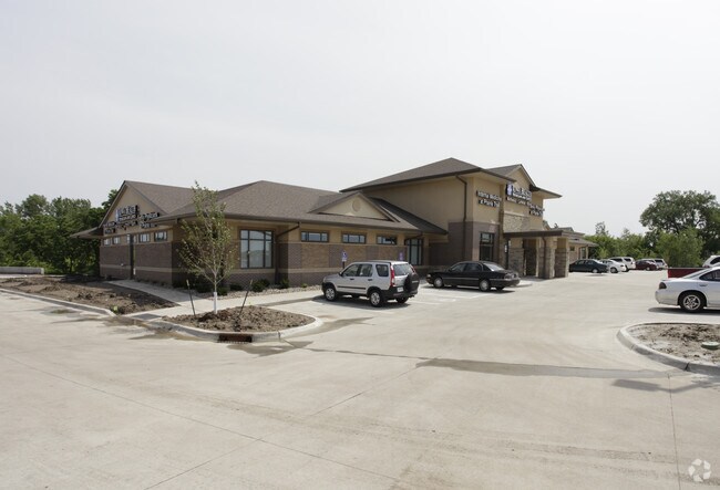
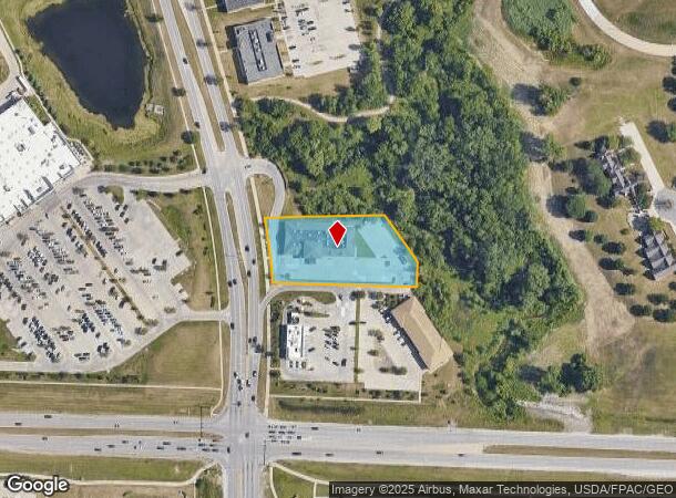
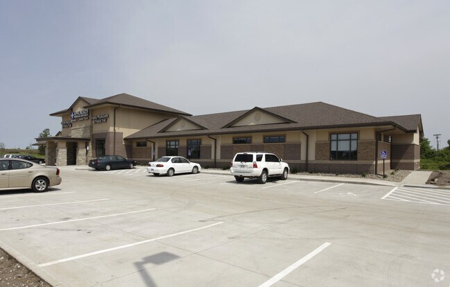
Property Record
2515 Sw State St, Ankeny, IA 50023
NEARBY LISTINGS FOR SALE OR LEASE
Property Detail
2515 Sw State St
Des Moines-West Des Moines, IA
State Street Plaza Plat 1
181-00557250003
LOT 3 STATE STREET PLAZA PLAT 1
Officebuilding
Polk
X
Iowa
19153C0205F
3
2024
1.51 AC
2025
Ankeny
010205
Des Moines
13,886 SF
DEMOGRAPHICS near 2515 Sw State St
1 Mile
3 Mile
5 Mile
2024 Total Population
10,770
51,398
97,762
2029 Population
11,474
53,708
102,584
Pop Growth 2024-2029
+ 6.54%
+ 4.49%
+ 4.93%
Average Age
35
38
37
2024 Total Households
4,169
20,102
37,919
HH Growth 2024-2029
+ 6.81%
+ 4.72%
+ 5.12%
Median Household Inc
$102,763
$90,074
$89,174
Avg Household Size
2.50
2.50
2.50
2024 Avg HH Vehicles
2.00
2.00
2.00
Median Home Value
$270,231
$260,722
$275,924
Median Year Built
2010
1999
2002
Nearby Places
Map Layers
Map Styles
 Street
 Aerial
- Restaurants
- Banks
- Shops
- Fitness
- Groceries
PUBLIC TRANSPORTATION
AIRPORT
Des Moines International
DRIVE
WALK
Distance
Des Moines International
27 min
13.7 mi
Freight Ports
Port Milwaukee
DRIVE
WALK
Distance
Port Milwaukee
416 min
374.1 mi
Nearby Properties
Address
Land Use
TOTAL SIZE
Lot Size
Zoning
Address
Land Use
TOTAL SIZE
Lot Size
Zoning
2,732,552 SF
443.35 AC
Address
Land Use
TOTAL SIZE
Lot Size
Zoning
723,056 SF
83.96 AC
M1
Address
Land Use
TOTAL SIZE
Lot Size
Zoning
857,109 SF
73.97 AC
LI
Address
Land Use
TOTAL SIZE
Lot Size
Zoning
644,568 SF
29.90 AC
M-1
Address
Land Use
TOTAL SIZE
Lot Size
Zoning
463,530 SF
35.91 AC
M-1
Address
Land Use
TOTAL SIZE
Lot Size
Zoning
272,072 SF
11.70 AC
Address
Land Use
TOTAL SIZE
Lot Size
Zoning
350,150 SF
35.34 AC
Address
Land Use
TOTAL SIZE
Lot Size
Zoning
296,500 SF
24.36 AC
Address
Land Use
TOTAL SIZE
Lot Size
Zoning
644,942 SF
60.73 AC
M-1
Address
Land Use
TOTAL SIZE
Lot Size
Zoning
100,751 SF
12.67 AC
C-2
Address
Land Use
TOTAL SIZE
Lot Size
Zoning
263,250 SF
30.10 AC
M-1
Address
Land Use
TOTAL SIZE
Lot Size
Zoning
198,454 SF
12.04 AC
Address
Land Use
TOTAL SIZE
Lot Size
Zoning
254,801 SF
20.05 AC
Address
Land Use
TOTAL SIZE
Lot Size
Zoning
300,000 SF
18.98 AC
Address
Land Use
TOTAL SIZE
Lot Size
Zoning
140,045 SF
9.29 AC
Address
Land Use
TOTAL SIZE
Lot Size
Zoning
200,860 SF
11.25 AC
Address
Land Use
TOTAL SIZE
Lot Size
Zoning
143,249 SF
7.19 AC
Address
Land Use
TOTAL SIZE
Lot Size
Zoning
200,220 SF
15.61 AC
Address
Land Use
TOTAL SIZE
Lot Size
Zoning
275,000 SF
16.17 AC
HI
Address
Land Use
TOTAL SIZE
Lot Size
Zoning
200,688 SF
20.26 AC
Address
Land Use
TOTAL SIZE
Lot Size
Zoning
206,000 SF
19.12 AC
Address
Land Use
TOTAL SIZE
Lot Size
Zoning
90,381 SF
19.28 AC
R-3
Address
Land Use
TOTAL SIZE
Lot Size
Zoning
143,012 SF
1.75 AC
Address
Land Use
TOTAL SIZE
Lot Size
Zoning
170,692 SF
6.54 AC
Address
Land Use
TOTAL SIZE
Lot Size
Zoning
96,344 SF
13.39 AC
PUD
Address
Land Use
TOTAL SIZE
Lot Size
Zoning
180,000 SF
11.72 AC
Address
Land Use
TOTAL SIZE
Lot Size
Zoning
175,424 SF
8.01 AC
Address
Land Use
TOTAL SIZE
Lot Size
Zoning
162,384 SF
11.16 AC
R-3
Address
Land Use
TOTAL SIZE
Lot Size
Zoning
211,986 SF
20.98 AC
Address
Land Use
TOTAL SIZE
Lot Size
Zoning
174,602 SF
15.47 AC
The World's #1 Commercial Real Estate Marketplace
Connect with us
© 2025 CoStar Group
The information above has been obtained from sources believed reliable. While we do not doubt its accuracy we have not verified it and make no guarantee, warranty or representation about it. It is your responsibility to independently confirm its accuracy and completeness. Any projections, opinions, assumptions, or estimates used are for example only and do not represent the current or future performance of the property. The value of this transaction to you depends on tax and other factors which should be evaluated by your tax, financial, and legal advisors. You and your advisors should conduct a careful, independent investigation of the property to determine to your satisfaction the suitability of the property for your needs.