Property Record
2517 Adie Rd, Maryland Heights, MO 63043
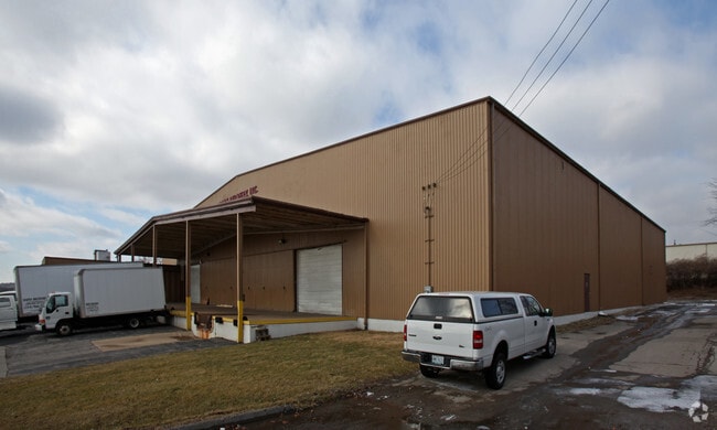

This Property Is For Sale
NEARBY LISTINGS FOR SALE OR LEASE
Property Detail
2517 Adie Rd
St. Louis, MO-IL
Arcliff Industrial Park
14N-33-0525
ARCLIFF INDUSTRIAL PARK LOT PTS 1 & 2
Warehouse
St. Louis
X
Missouri
29189C0183K
1,2
2024
1.55 AC
2025
Westport
215001
St. Louis
22,556 SF
DEMOGRAPHICS near 2517 Adie Rd
1 Mile
3 Mile
5 Mile
2024 Total Population
4,064
89,660
167,353
2029 Population
3,984
88,077
164,650
Pop Growth 2024-2029
(1.97%)
(1.77%)
(1.62%)
Average Age
38
40
41
2024 Total Households
1,789
39,168
72,047
HH Growth 2024-2029
(2.07%)
(1.84%)
(1.65%)
Median Household Inc
$71,718
$65,740
$66,817
Avg Household Size
2.20
2.20
2.20
2024 Avg HH Vehicles
2.00
2.00
2.00
Median Home Value
$201,240
$184,316
$204,461
Median Year Built
1969
1967
1965
Nearby Places
Map Layers
Map Styles
 Street
 Aerial
- Restaurants
- Banks
- Shops
- Fitness
- Groceries
PUBLIC TRANSPORTATION
COMMUTER RAIL
Lambert Airport East Terminal (Lambert Airport Shiloh-Scott - St. Louis MetroLink (MetroLink))
DRIVE
WALK
Distance
Lambert Airport East Terminal (Lambert Airport Shiloh-Scott - St. Louis MetroLink (MetroLink))
12 min
6.0 mi
Lambert Airport Main Terminal (Lambert Airport Shiloh-Scott - St. Louis MetroLink (MetroLink))
DRIVE
WALK
Distance
Lambert Airport Main Terminal (Lambert Airport Shiloh-Scott - St. Louis MetroLink (MetroLink))
14 min
6.5 mi
AIRPORT
St Louis Lambert International
DRIVE
WALK
Distance
St Louis Lambert International
16 min
8.1 mi
Freight Ports
Port Milwaukee
DRIVE
WALK
Distance
Port Milwaukee
438 min
384.5 mi
Nearby Properties
Address
Land Use
TOTAL SIZE
Lot Size
Zoning
Address
Land Use
TOTAL SIZE
Lot Size
Zoning
1,053,686 SF
31.40 AC
43M-1
Address
Land Use
TOTAL SIZE
Lot Size
Zoning
52.13 AC
42PA
Address
Land Use
TOTAL SIZE
Lot Size
Zoning
201,879 SF
29.52 AC
82RO
Address
Land Use
TOTAL SIZE
Lot Size
Zoning
1,280,539 SF
151.20 AC
H
Address
Land Use
TOTAL SIZE
Lot Size
Zoning
544,556 SF
95.75 AC
H
Address
Land Use
TOTAL SIZE
Lot Size
Zoning
369,418 SF
7.22 AC
104PDM
Address
Land Use
TOTAL SIZE
Lot Size
Zoning
292,543 SF
10.11 AC
CB
Address
Land Use
TOTAL SIZE
Lot Size
Zoning
26.89 AC
C-8
Address
Land Use
TOTAL SIZE
Lot Size
Zoning
1,190 SF
49.03 AC
104R-5
Address
Land Use
TOTAL SIZE
Lot Size
Zoning
46,752 SF
3.67 AC
82CB
Address
Land Use
TOTAL SIZE
Lot Size
Zoning
234,421 SF
2.01 AC
82CB
Address
Land Use
TOTAL SIZE
Lot Size
Zoning
228,816 SF
1.70 AC
82CB
Address
Land Use
TOTAL SIZE
Lot Size
Zoning
290,380 SF
9.97 AC
82CB
Address
Land Use
TOTAL SIZE
Lot Size
Zoning
288,322 SF
19.72 AC
104PDM
Address
Land Use
TOTAL SIZE
Lot Size
Zoning
160,628 SF
1.47 AC
82R0
Address
Land Use
TOTAL SIZE
Lot Size
Zoning
319,398 SF
15.58 AC
10M-3
Address
Land Use
TOTAL SIZE
Lot Size
Zoning
36.41 AC
R2
Address
Land Use
TOTAL SIZE
Lot Size
Zoning
389,367 SF
29.15 AC
R6
Address
Land Use
TOTAL SIZE
Lot Size
Zoning
339,604 SF
35.30 AC
M1
Address
Land Use
TOTAL SIZE
Lot Size
Zoning
247,086 SF
11.32 AC
104PDM
Address
Land Use
TOTAL SIZE
Lot Size
Zoning
193,158 SF
3.60 AC
82GC
Address
Land Use
TOTAL SIZE
Lot Size
Zoning
353,407 SF
21.84 AC
104R-4
Address
Land Use
TOTAL SIZE
Lot Size
Zoning
181,103 SF
7.57 AC
82CB
Address
Land Use
TOTAL SIZE
Lot Size
Zoning
216,290 SF
10.39 AC
104MXD
Address
Land Use
TOTAL SIZE
Lot Size
Zoning
245,474 SF
6.52 AC
10B-3
Address
Land Use
TOTAL SIZE
Lot Size
Zoning
225,558 SF
14.48 AC
104R-6
Address
Land Use
TOTAL SIZE
Lot Size
Zoning
172,059 SF
25.52 AC
R1
Address
Land Use
TOTAL SIZE
Lot Size
Zoning
362,986 SF
30.31 AC
R6
Address
Land Use
TOTAL SIZE
Lot Size
Zoning
124,000 SF
5.15 AC
102COMCL
Address
Land Use
TOTAL SIZE
Lot Size
Zoning
191,392 SF
4.85 AC
104PDM
The World's #1 Commercial Real Estate Marketplace
Connect with us
© 2026 CoStar Group
The information above has been obtained from sources believed reliable. While we do not doubt its accuracy we have not verified it and make no guarantee, warranty or representation about it. It is your responsibility to independently confirm its accuracy and completeness. Any projections, opinions, assumptions, or estimates used are for example only and do not represent the current or future performance of the property. The value of this transaction to you depends on tax and other factors which should be evaluated by your tax, financial, and legal advisors. You and your advisors should conduct a careful, independent investigation of the property to determine to your satisfaction the suitability of the property for your needs.