Property Record
2517 Northgate St, Ottumwa, IA 52501
NEARBY LISTINGS FOR SALE OR LEASE
-
-
View all Ottumwa listings for sale on LoopNet.com
Property Detail
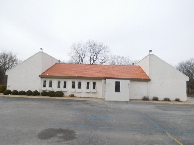
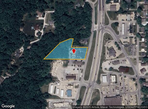
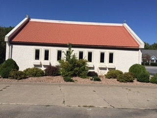
2517 Northgate St
Other Market Areas
Schlunz's Northgate 2Nd Add
Ottumwa, IA
SCHLUNZ'S NORTHGATE 2ND ADD LOT 6 BEING PT NESE 12-72-14 (2517 NORTHGATE)
007414470006000
Wapello
Restaurantbuilding
Iowa
2025
6
2025
1.83 AC
960300
Iowa Southeast Area
3,064 SF
DEMOGRAPHICS near 2517 Northgate St
1 Mile
3 Mile
5 Mile
2024 Total Population
3,569
13,945
27,691
2029 Population
3,504
13,757
27,211
Pop Growth 2024-2029
(1.82%)
(1.35%)
(1.73%)
Average Age
39
38
39
2024 Total Households
1,336
5,395
10,958
HH Growth 2024-2029
(2.02%)
(1.43%)
(1.81%)
Median Household Inc
$71,456
$58,421
$50,160
Avg Household Size
2.40
2.40
2.40
2024 Avg HH Vehicles
2.00
2.00
2.00
Median Home Value
$147,007
$127,064
$92,058
Median Year Built
1963
1955
1954
Nearby Places
Map Layers
Map Styles
 Street
 Aerial
- Restaurants
- Banks
- Shops
- Fitness
- Groceries
SALE & LEASE HISTORY
LISTING DATE
SALE/LEASE

May 10, 2017
For Sale
Dec 28, 2016
For Sale
Nearby Properties
Address
Land Use
TOTAL SIZE
Lot Size
Zoning
Address
Land Use
TOTAL SIZE
Lot Size
Zoning
1,680 SF
17.26 AC
Address
Land Use
TOTAL SIZE
Lot Size
Zoning
97,103 SF
0.35 AC
Address
Land Use
TOTAL SIZE
Lot Size
Zoning
1.01 AC
Address
Land Use
TOTAL SIZE
Lot Size
Zoning
34,134 SF
9.89 AC
Address
Land Use
TOTAL SIZE
Lot Size
Zoning
32,796 SF
5.10 AC
Address
Land Use
TOTAL SIZE
Lot Size
Zoning
87,967 SF
4.28 AC
Address
Land Use
TOTAL SIZE
Lot Size
Zoning
41,660 SF
0.55 AC
Address
Land Use
TOTAL SIZE
Lot Size
Zoning
24,094 SF
4 AC
Address
Land Use
TOTAL SIZE
Lot Size
Zoning
47,341 SF
2.33 AC
Address
Land Use
TOTAL SIZE
Lot Size
Zoning
51,520 SF
8.37 AC
Address
Land Use
TOTAL SIZE
Lot Size
Zoning
217,810 SF
7.80 AC
Address
Land Use
TOTAL SIZE
Lot Size
Zoning
12,620 SF
4.87 AC
Address
Land Use
TOTAL SIZE
Lot Size
Zoning
86,534 SF
8.77 AC
Address
Land Use
TOTAL SIZE
Lot Size
Zoning
7,995 SF
0.14 AC
Address
Land Use
TOTAL SIZE
Lot Size
Zoning
36,586 SF
0.15 AC
Address
Land Use
TOTAL SIZE
Lot Size
Zoning
3,440 SF
3.95 AC
Address
Land Use
TOTAL SIZE
Lot Size
Zoning
49,084 SF
3.87 AC
Address
Land Use
TOTAL SIZE
Lot Size
Zoning
40,939 SF
5.72 AC
Address
Land Use
TOTAL SIZE
Lot Size
Zoning
18,457 SF
0.57 AC
Address
Land Use
TOTAL SIZE
Lot Size
Zoning
33,060 SF
3.83 AC
Address
Land Use
TOTAL SIZE
Lot Size
Zoning
65,762 SF
7.96 AC
Address
Land Use
TOTAL SIZE
Lot Size
Zoning
29,226 SF
0.14 AC
Address
Land Use
TOTAL SIZE
Lot Size
Zoning
7,044 SF
2.39 AC
Address
Land Use
TOTAL SIZE
Lot Size
Zoning
178,592 SF
5.35 AC
Address
Land Use
TOTAL SIZE
Lot Size
Zoning
11,086 SF
3.97 AC
Address
Land Use
TOTAL SIZE
Lot Size
Zoning
4.62 AC
Address
Land Use
TOTAL SIZE
Lot Size
Zoning
23,940 SF
1.13 AC
Address
Land Use
TOTAL SIZE
Lot Size
Zoning
22,672 SF
2.16 AC
Address
Land Use
TOTAL SIZE
Lot Size
Zoning
29,922 SF
5.38 AC
Address
Land Use
TOTAL SIZE
Lot Size
Zoning
19,320 SF
4.83 AC
The World's #1 Commercial Real Estate Marketplace
Connect with us
© 2025 CoStar Group
The information above has been obtained from sources believed reliable. While we do not doubt its accuracy we have not verified it and make no guarantee, warranty or representation about it. It is your responsibility to independently confirm its accuracy and completeness. Any projections, opinions, assumptions, or estimates used are for example only and do not represent the current or future performance of the property. The value of this transaction to you depends on tax and other factors which should be evaluated by your tax, financial, and legal advisors. You and your advisors should conduct a careful, independent investigation of the property to determine to your satisfaction the suitability of the property for your needs.