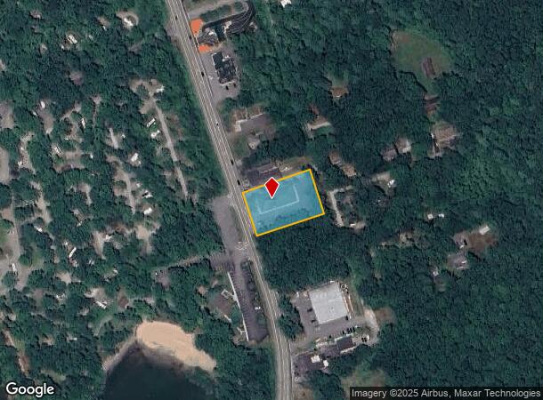
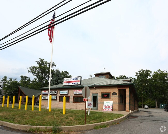
Property Record
2517 Route 6, Hawley, PA 18428

NEARBY LISTINGS FOR SALE OR LEASE
Property Detail
2517 Route 6
Newark, NJ-PA
Taft Co Wilson Hill Dev
060647
LOTS 9,18,19,20,21 & 22 BLK A OFFICE BUILDING
Storesoffices
Pike
X
Pennsylvania
42127C0410D
9,18-
2024
0.91 AC
2025
Pike County
950303
Northern New Jersey
6,000 SF
DEMOGRAPHICS near 2517 Route 6
1 Mile
3 Mile
5 Mile
2024 Total Population
362
4,698
8,631
2029 Population
388
4,942
9,135
Pop Growth 2024-2029
+ 7.18%
+ 5.19%
+ 5.84%
Average Age
48
47
48
2024 Total Households
159
2,092
3,835
HH Growth 2024-2029
+ 6.92%
+ 4.97%
+ 5.74%
Median Household Inc
$53,382
$53,369
$58,290
Avg Household Size
2.20
2.20
2.20
2024 Avg HH Vehicles
2.00
2.00
2.00
Median Home Value
$251,020
$245,253
$251,800
Median Year Built
1979
1977
1981
Nearby Places
Map Layers
Map Styles
 Street
 Aerial
- Restaurants
- Banks
- Shops
- Fitness
- Groceries
PUBLIC TRANSPORTATION
AIRPORT
Wilkes-Barre/Scranton International
DRIVE
WALK
Distance
Wilkes-Barre/Scranton International
59 min
43.8 mi
Freight Ports
Maher Terminal
DRIVE
WALK
Distance
Maher Terminal
132 min
90.0 mi
SALE & LEASE HISTORY
LISTING DATE
SALE/LEASE

Sep 25, 2016
For Lease
Nearby Properties
Address
Land Use
TOTAL SIZE
Lot Size
Zoning
Address
Land Use
TOTAL SIZE
Lot Size
Zoning
Address
Land Use
TOTAL SIZE
Lot Size
Zoning
5.93 AC
B2
Address
Land Use
TOTAL SIZE
Lot Size
Zoning
6.70 AC
Address
Land Use
TOTAL SIZE
Lot Size
Zoning
3.67 AC
Address
Land Use
TOTAL SIZE
Lot Size
Zoning
13.88 AC
C1
Address
Land Use
TOTAL SIZE
Lot Size
Zoning
0.79 AC
Address
Land Use
TOTAL SIZE
Lot Size
Zoning
3,575 SF
0.56 AC
R-1
Address
Land Use
TOTAL SIZE
Lot Size
Zoning
11.53 AC
C1
Address
Land Use
TOTAL SIZE
Lot Size
Zoning
235,718 SF
30.55 AC
Address
Land Use
TOTAL SIZE
Lot Size
Zoning
6,927 SF
0.17 AC
B2
Address
Land Use
TOTAL SIZE
Lot Size
Zoning
755 SF
0.81 AC
B2
Address
Land Use
TOTAL SIZE
Lot Size
Zoning
0.17 AC
B-2
Address
Land Use
TOTAL SIZE
Lot Size
Zoning
1.20 AC
I1
Address
Land Use
TOTAL SIZE
Lot Size
Zoning
2.79 AC
B2
Address
Land Use
TOTAL SIZE
Lot Size
Zoning
1.20 AC
Address
Land Use
TOTAL SIZE
Lot Size
Zoning
7,840 SF
3,084.93 AC
Address
Land Use
TOTAL SIZE
Lot Size
Zoning
788 SF
6.63 AC
B2
Address
Land Use
TOTAL SIZE
Lot Size
Zoning
1.51 AC
B2
Address
Land Use
TOTAL SIZE
Lot Size
Zoning
3.40 AC
B2
Address
Land Use
TOTAL SIZE
Lot Size
Zoning
3,290 SF
4.17 AC
Address
Land Use
TOTAL SIZE
Lot Size
Zoning
3.29 AC
C1
Address
Land Use
TOTAL SIZE
Lot Size
Zoning
1.03 AC
B-2
Address
Land Use
TOTAL SIZE
Lot Size
Zoning
2.86 AC
Address
Land Use
TOTAL SIZE
Lot Size
Zoning
0.27 AC
Address
Land Use
TOTAL SIZE
Lot Size
Zoning
3,360 SF
1.39 AC
Address
Land Use
TOTAL SIZE
Lot Size
Zoning
0.83 AC
R1
Address
Land Use
TOTAL SIZE
Lot Size
Zoning
2.77 AC
The World's #1 Commercial Real Estate Marketplace
Connect with us
© 2026 CoStar Group
The information above has been obtained from sources believed reliable. While we do not doubt its accuracy we have not verified it and make no guarantee, warranty or representation about it. It is your responsibility to independently confirm its accuracy and completeness. Any projections, opinions, assumptions, or estimates used are for example only and do not represent the current or future performance of the property. The value of this transaction to you depends on tax and other factors which should be evaluated by your tax, financial, and legal advisors. You and your advisors should conduct a careful, independent investigation of the property to determine to your satisfaction the suitability of the property for your needs.