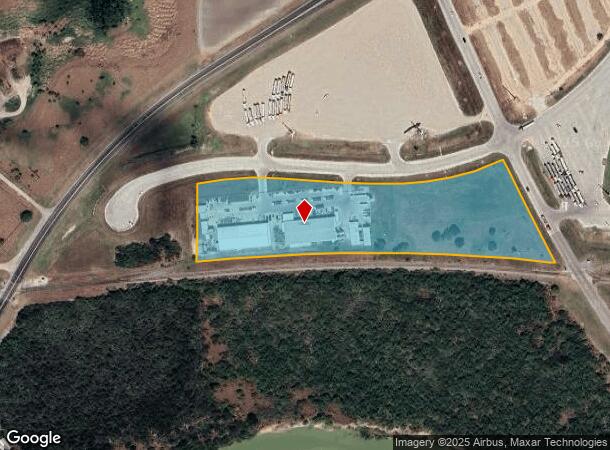
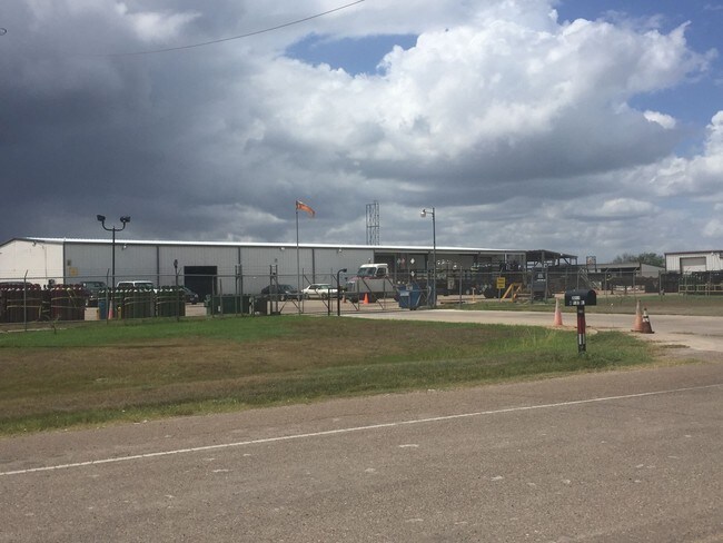
Property Record
25191 W Port Rd, Harlingen, TX 78550

NEARBY LISTINGS FOR SALE OR LEASE
Property Detail
25191 W Port Rd
988360-0000-021100
Williams E M L Survey #276
Industrialgeneral
WILLIAMS E M L SURVEY #276 6.55 ACRES OF CAMERON COUNTY SCHOOL LANDS & RGNG RAIL ROAD CO OF A 218.45 ACRES TRACT
X
Cameron
48061C0300F
Texas
2024
6.55 AC
2025
Outlying Cameron County
010802
Brownsville/Harlingen
28,090 SF
Brownsville-Harlingen, TX
DEMOGRAPHICS near 25191 W Port Rd
1 Mile
3 Mile
5 Mile
2024 Total Population
671
4,349
46,925
2029 Population
720
4,488
47,949
Pop Growth 2024-2029
+ 7.30%
+ 3.20%
+ 2.18%
Average Age
36
37
37
2024 Total Households
185
1,265
15,982
HH Growth 2024-2029
+ 7.03%
+ 3.00%
+ 2.11%
Median Household Inc
$57,856
$54,159
$47,764
Avg Household Size
3.30
3.10
2.80
2024 Avg HH Vehicles
2.00
2.00
2.00
Median Home Value
$64,919
$124,162
$104,431
Median Year Built
1994
1995
1985
Nearby Places
Map Layers
Map Styles
 Street
 Aerial
- Restaurants
- Banks
- Shops
- Fitness
- Groceries
PUBLIC TRANSPORTATION
AIRPORT
Valley International
DRIVE
WALK
Distance
Valley International
13 min
6.9 mi
Brownsville/South Padre Island International
DRIVE
WALK
Distance
Brownsville/South Padre Island International
41 min
27.4 mi
Freight Ports
Port of Brownsville
DRIVE
WALK
Distance
Port of Brownsville
33 min
25.1 mi
Nearby Properties
Address
Land Use
TOTAL SIZE
Lot Size
Zoning
Address
Land Use
TOTAL SIZE
Lot Size
Zoning
663,572 SF
60.74 AC
I
Address
Land Use
TOTAL SIZE
Lot Size
Zoning
188,102 SF
45.81 AC
C
Address
Land Use
TOTAL SIZE
Lot Size
Zoning
105,000 SF
9.15 AC
C
Address
Land Use
TOTAL SIZE
Lot Size
Zoning
88,964 SF
4.38 AC
I
Address
Land Use
TOTAL SIZE
Lot Size
Zoning
68,901 SF
5.49 AC
C
Address
Land Use
TOTAL SIZE
Lot Size
Zoning
80,000 SF
19.63 AC
C
Address
Land Use
TOTAL SIZE
Lot Size
Zoning
55,660 SF
13.71 AC
C
Address
Land Use
TOTAL SIZE
Lot Size
Zoning
65,088 SF
4.20 AC
C
Address
Land Use
TOTAL SIZE
Lot Size
Zoning
50,128 SF
10 AC
Address
Land Use
TOTAL SIZE
Lot Size
Zoning
34,489 SF
5.23 AC
Address
Land Use
TOTAL SIZE
Lot Size
Zoning
43,032 SF
16.56 AC
I
Address
Land Use
TOTAL SIZE
Lot Size
Zoning
63,000 SF
6.38 AC
I
Address
Land Use
TOTAL SIZE
Lot Size
Zoning
60,194 SF
23.95 AC
Address
Land Use
TOTAL SIZE
Lot Size
Zoning
31,840 SF
8.18 AC
Address
Land Use
TOTAL SIZE
Lot Size
Zoning
51,346 SF
6.84 AC
C
Address
Land Use
TOTAL SIZE
Lot Size
Zoning
60,000 SF
5 AC
Address
Land Use
TOTAL SIZE
Lot Size
Zoning
33,516 SF
8.92 AC
Address
Land Use
TOTAL SIZE
Lot Size
Zoning
22,012 SF
9.74 AC
Address
Land Use
TOTAL SIZE
Lot Size
Zoning
30,000 SF
8.26 AC
I
Address
Land Use
TOTAL SIZE
Lot Size
Zoning
25,200 SF
19.88 AC
Address
Land Use
TOTAL SIZE
Lot Size
Zoning
35,028 SF
3 AC
I
Address
Land Use
TOTAL SIZE
Lot Size
Zoning
2,400 SF
6 AC
A-R
Address
Land Use
TOTAL SIZE
Lot Size
Zoning
15,072 SF
18 AC
Address
Land Use
TOTAL SIZE
Lot Size
Zoning
38,340 SF
4.50 AC
Address
Land Use
TOTAL SIZE
Lot Size
Zoning
8,988 SF
1.60 AC
Address
Land Use
TOTAL SIZE
Lot Size
Zoning
24,000 SF
2.14 AC
Address
Land Use
TOTAL SIZE
Lot Size
Zoning
25,600 SF
4.50 AC
Address
Land Use
TOTAL SIZE
Lot Size
Zoning
19,800 SF
3.83 AC
Address
Land Use
TOTAL SIZE
Lot Size
Zoning
33,750 SF
20.04 AC
Address
Land Use
TOTAL SIZE
Lot Size
Zoning
105.65 AC
C
The World's #1 Commercial Real Estate Marketplace
Connect with us
© 2026 CoStar Group
The information above has been obtained from sources believed reliable. While we do not doubt its accuracy we have not verified it and make no guarantee, warranty or representation about it. It is your responsibility to independently confirm its accuracy and completeness. Any projections, opinions, assumptions, or estimates used are for example only and do not represent the current or future performance of the property. The value of this transaction to you depends on tax and other factors which should be evaluated by your tax, financial, and legal advisors. You and your advisors should conduct a careful, independent investigation of the property to determine to your satisfaction the suitability of the property for your needs.