Property Record
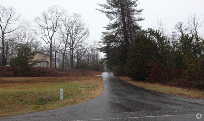
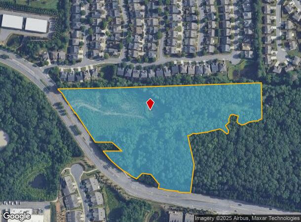
252 Mathis Airport Pkwy, Suwanee, GA 30024
NEARBY LISTINGS FOR SALE OR LEASE
Property Detail
252 Mathis Airport Pkwy
Atlanta-Sandy Springs-Roswell, GA
South Forsyth
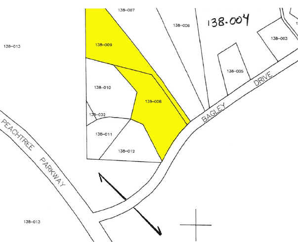
138-008
2-1 1064
Commercialnec
Forsyth
A
Georgia
13117C0235F
1091
2024
12.25 AC
2025
N Fulton/Forsyth County
050243
Atlanta
DEMOGRAPHICS near 252 Mathis Airport Pkwy
1 Mile
3 Mile
5 Mile
2024 Total Population
7,165
64,618
172,499
2029 Population
8,275
71,865
189,076
Pop Growth 2024-2029
+ 15.49%
+ 11.22%
+ 9.61%
Average Age
40
39
38
2024 Total Households
2,345
20,244
56,091
HH Growth 2024-2029
+ 15.57%
+ 11.25%
+ 9.58%
Median Household Inc
$141,468
$164,507
$145,318
Avg Household Size
3.00
3.10
3.00
2024 Avg HH Vehicles
2.00
2.00
2.00
Median Home Value
$517,116
$536,022
$490,549
Median Year Built
2004
1999
2000
Nearby Places
Map Layers
Map Styles
 Street
 Aerial
- Restaurants
- Banks
- Shops
- Fitness
- Groceries
Nearby Properties
Address
Land Use
TOTAL SIZE
Lot Size
Zoning
Address
Land Use
TOTAL SIZE
Lot Size
Zoning
321,541 SF
63.16 AC
OI
Address
Land Use
TOTAL SIZE
Lot Size
Zoning
559,910 SF
74.65 AC
Address
Land Use
TOTAL SIZE
Lot Size
Zoning
299,952 SF
23.49 AC
MIAC
Address
Land Use
TOTAL SIZE
Lot Size
Zoning
321,116 SF
17.06 AC
CBD
Address
Land Use
TOTAL SIZE
Lot Size
Zoning
47,721 SF
12.99 AC
CBD
Address
Land Use
TOTAL SIZE
Lot Size
Zoning
249,386 SF
33.24 AC
RES6
Address
Land Use
TOTAL SIZE
Lot Size
Zoning
291,232 SF
71.66 AC
RES3
Address
Land Use
TOTAL SIZE
Lot Size
Zoning
170,400 SF
24.98 AC
M1
Address
Land Use
TOTAL SIZE
Lot Size
Zoning
222,893 SF
103.13 AC
M1
Address
Land Use
TOTAL SIZE
Lot Size
Zoning
141,728 SF
32.45 AC
M1
Address
Land Use
TOTAL SIZE
Lot Size
Zoning
232,832 SF
17.74 AC
M1
Address
Land Use
TOTAL SIZE
Lot Size
Zoning
343,180 SF
17.29 AC
OI
Address
Land Use
TOTAL SIZE
Lot Size
Zoning
122,964 SF
7.82 AC
RES6
Address
Land Use
TOTAL SIZE
Lot Size
Zoning
163,592 SF
17.60 AC
OI
Address
Land Use
TOTAL SIZE
Lot Size
Zoning
184,680 SF
18.22 AC
M1
Address
Land Use
TOTAL SIZE
Lot Size
Zoning
91,296 SF
12.76 AC
CBD
Address
Land Use
TOTAL SIZE
Lot Size
Zoning
14,880 SF
16.51 AC
CBD
Address
Land Use
TOTAL SIZE
Lot Size
Zoning
101,510 SF
15.45 AC
CBD
Address
Land Use
TOTAL SIZE
Lot Size
Zoning
102,784 SF
9.16 AC
MIAC
Address
Land Use
TOTAL SIZE
Lot Size
Zoning
45,603 SF
8.36 AC
CBD
Address
Land Use
TOTAL SIZE
Lot Size
Zoning
126,793 SF
10.78 AC
M1
Address
Land Use
TOTAL SIZE
Lot Size
Zoning
117,036 SF
13.62 AC
CBD
Address
Land Use
TOTAL SIZE
Lot Size
Zoning
136,122 SF
9.95 AC
M1
Address
Land Use
TOTAL SIZE
Lot Size
Zoning
136,660 SF
21.47 AC
M1
Address
Land Use
TOTAL SIZE
Lot Size
Zoning
169,042 SF
19.36 AC
M1
Address
Land Use
TOTAL SIZE
Lot Size
Zoning
73,022 SF
6.57 AC
CBD
Address
Land Use
TOTAL SIZE
Lot Size
Zoning
158,772 SF
15.93 AC
M1
Address
Land Use
TOTAL SIZE
Lot Size
Zoning
73,963 SF
10.57 AC
CBD
Address
Land Use
TOTAL SIZE
Lot Size
Zoning
88,288 SF
7.76 AC
C1
Address
Land Use
TOTAL SIZE
Lot Size
Zoning
126,920 SF
12.25 AC
M1
The World's #1 Commercial Real Estate Marketplace
Connect with us
© 2025 CoStar Group
The information above has been obtained from sources believed reliable. While we do not doubt its accuracy we have not verified it and make no guarantee, warranty or representation about it. It is your responsibility to independently confirm its accuracy and completeness. Any projections, opinions, assumptions, or estimates used are for example only and do not represent the current or future performance of the property. The value of this transaction to you depends on tax and other factors which should be evaluated by your tax, financial, and legal advisors. You and your advisors should conduct a careful, independent investigation of the property to determine to your satisfaction the suitability of the property for your needs.