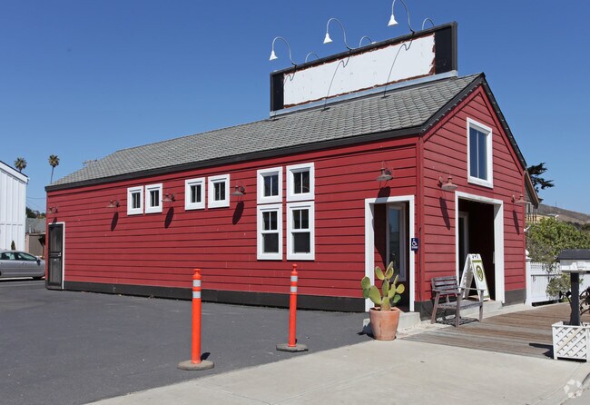
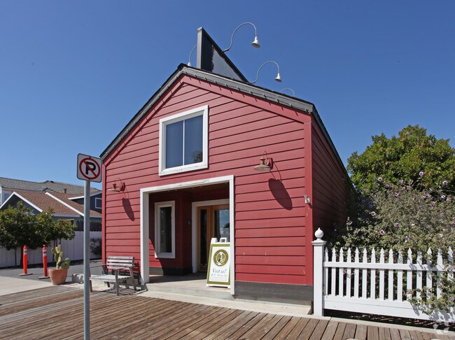
Property Record
252 N Ocean Ave, Cayucos, CA 93430

NEARBY LISTINGS FOR SALE OR LEASE
-
-
View all Cayucos listings for sale on LoopNet.com
Property Detail
252 N Ocean Ave
064-094-037
Parcel Map Co 05-0018
Sfr
PM 66/53-55 PAR 3
AE
San Luis Obispo
06079C0783H
California
0
0.08 AC
2025
Coastal SLO
010504
San Luis Obispo/Paso Robles
3,539 SF
San Luis Obispo-Paso Robles, CA
DEMOGRAPHICS near 252 N Ocean Ave
1 mile
3 mile
5 mile
2024 Total Population
1,781
4,030
7,981
2029 Population
1,900
4,297
8,374
Pop Growth 2024-2029
+ 6.68%
+ 6.63%
+ 4.92%
Average Age
52
51
49
2024 Total Households
919
1,982
3,693
HH Growth 2024-2029
+ 6.53%
+ 6.51%
+ 4.98%
Median Household Inc
$67,705
$78,424
$83,333
Avg Household Size
1.90
2.00
2.10
2024 Avg HH Vehicles
2.00
2.00
2.00
Median Home Value
$1,031,500
$975,961
$904,028
Median Year Built
1980
1976
1976
Nearby Places
Map Layers
Map Styles
 Street
 Aerial
Transit
 Traffic
 Biking
Places
Listings with unknown addresses are not visible on the map
- Restaurants
- Banks
- Shops
- Fitness
- Groceries
PUBLIC TRANSPORTATION
AIRPORT
San Luis County Regional
Drive
Walk
Distance
San Luis County Regional
37 min
24.8 mi
Freight Ports
The Port of Hueneme
Drive
Walk
Distance
The Port of Hueneme
195 min
152.8 mi
Nearby Properties
Address
Land Use
TOTAL SIZE
Lot Size
Zoning
Address
Land Use
TOTAL SIZE
Lot Size
Zoning
7.18 AC
RSF
Address
Land Use
TOTAL SIZE
Lot Size
Zoning
3,296 SF
0.38 AC
RSF
Address
Land Use
TOTAL SIZE
Lot Size
Zoning
4,624 SF
0.55 AC
RSF
Address
Land Use
TOTAL SIZE
Lot Size
Zoning
3,680 SF
0.13 AC
RSF
Address
Land Use
TOTAL SIZE
Lot Size
Zoning
3,134 SF
0.10 AC
RSF
Address
Land Use
TOTAL SIZE
Lot Size
Zoning
2,357 SF
0.20 AC
RSF
Address
Land Use
TOTAL SIZE
Lot Size
Zoning
3,149 SF
0.12 AC
RSF
Address
Land Use
TOTAL SIZE
Lot Size
Zoning
1,906 SF
0.35 AC
RSF
Address
Land Use
TOTAL SIZE
Lot Size
Zoning
3,128 SF
0.14 AC
RSF
Address
Land Use
TOTAL SIZE
Lot Size
Zoning
9,230 SF
0.21 AC
CR
Address
Land Use
TOTAL SIZE
Lot Size
Zoning
2,061 SF
0.17 AC
RSF
Address
Land Use
TOTAL SIZE
Lot Size
Zoning
2,784 SF
0.10 AC
RSF
Address
Land Use
TOTAL SIZE
Lot Size
Zoning
4,240 SF
24.29 AC
AG
Address
Land Use
TOTAL SIZE
Lot Size
Zoning
3,064 SF
0.15 AC
RSF
Address
Land Use
TOTAL SIZE
Lot Size
Zoning
3,323 SF
0.27 AC
RSF
Address
Land Use
TOTAL SIZE
Lot Size
Zoning
2,909 SF
0.15 AC
RSF
Address
Land Use
TOTAL SIZE
Lot Size
Zoning
2,682 SF
0.11 AC
RSF
Address
Land Use
TOTAL SIZE
Lot Size
Zoning
3,394 SF
0.15 AC
RSF
Address
Land Use
TOTAL SIZE
Lot Size
Zoning
1,564 SF
10.70 AC
RMF
Address
Land Use
TOTAL SIZE
Lot Size
Zoning
3,064 SF
0.15 AC
RSF
Address
Land Use
TOTAL SIZE
Lot Size
Zoning
3,533 SF
0.17 AC
60
Address
Land Use
TOTAL SIZE
Lot Size
Zoning
2,600 SF
0.08 AC
RSF
Address
Land Use
TOTAL SIZE
Lot Size
Zoning
3,701 SF
0.21 AC
RMF
Address
Land Use
TOTAL SIZE
Lot Size
Zoning
2,838 SF
0.18 AC
RSF
Address
Land Use
TOTAL SIZE
Lot Size
Zoning
3,713 SF
0.14 AC
RSF
Address
Land Use
TOTAL SIZE
Lot Size
Zoning
2,888 SF
0.11 AC
RSF
Address
Land Use
TOTAL SIZE
Lot Size
Zoning
3,694 SF
0.18 AC
RSF
Address
Land Use
TOTAL SIZE
Lot Size
Zoning
1,369 SF
0.10 AC
20
Address
Land Use
TOTAL SIZE
Lot Size
Zoning
2,639 SF
0.18 AC
RSF
Address
Land Use
TOTAL SIZE
Lot Size
Zoning
2,180 SF
0.11 AC
RSF
The World's #1 Commercial Real Estate Marketplace
Connect with us
© 2026 CoStar Group
The information above has been obtained from sources believed reliable. While we do not doubt its accuracy we have not verified it and make no guarantee, warranty or representation about it. It is your responsibility to independently confirm its accuracy and completeness. Any projections, opinions, assumptions, or estimates used are for example only and do not represent the current or future performance of the property. The value of this transaction to you depends on tax and other factors which should be evaluated by your tax, financial, and legal advisors. You and your advisors should conduct a careful, independent investigation of the property to determine to your satisfaction the suitability of the property for your needs.