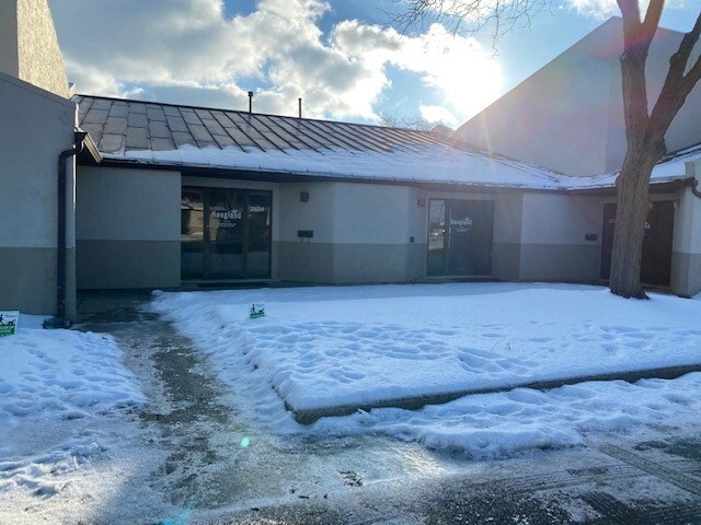
Property Record
2520 Billingsley Rd, Columbus, OH 43235


NEARBY LISTINGS FOR SALE OR LEASE
Property Detail
2520 Billingsley Rd
590-192151
Plat Of Flavel Tullers Survey
Officebuilding
BILLINGSLEY RD R19 T2 1/4T1 .779 ACRE
X
Franklin
39049C0152K
Ohio
2024
0.79 AC
2024
Bethel Rd
006397
Columbus
6,672 SF
Columbus, OH
DEMOGRAPHICS near 2520 Billingsley Rd
1 Mile
3 Mile
5 Mile
2024 Total Population
15,443
83,285
227,448
2029 Population
15,376
84,147
232,439
Pop Growth 2024-2029
(0.43%)
+ 1.04%
+ 2.19%
Average Age
36
39
39
2024 Total Households
6,545
32,963
93,656
HH Growth 2024-2029
(0.31%)
+ 1.13%
+ 1.91%
Median Household Inc
$73,809
$104,077
$97,489
Avg Household Size
2.30
2.50
2.40
2024 Avg HH Vehicles
2.00
2.00
2.00
Median Home Value
$298,248
$353,795
$362,434
Median Year Built
1986
1987
1987
Nearby Places
Map Layers
Map Styles
 Street
 Aerial
- Restaurants
- Banks
- Shops
- Fitness
- Groceries
PUBLIC TRANSPORTATION
AIRPORT
John Glenn Columbus International
DRIVE
WALK
Distance
John Glenn Columbus International
26 min
19.4 mi
Rickenbacker International
DRIVE
WALK
Distance
Rickenbacker International
39 min
30.2 mi
SALE & LEASE HISTORY
LISTING DATE
SALE/LEASE

Sep 28, 2016
For Lease
Mar 18, 2021
For Lease
Nearby Properties
Address
Land Use
TOTAL SIZE
Lot Size
Zoning
Address
Land Use
TOTAL SIZE
Lot Size
Zoning
182,845 SF
325.61 AC
Address
Land Use
TOTAL SIZE
Lot Size
Zoning
182,845 SF
325.61 AC
Address
Land Use
TOTAL SIZE
Lot Size
Zoning
133,425 SF
20.51 AC
Address
Land Use
TOTAL SIZE
Lot Size
Zoning
297,024 SF
71.76 AC
Address
Land Use
TOTAL SIZE
Lot Size
Zoning
557,021 SF
21.28 AC
Address
Land Use
TOTAL SIZE
Lot Size
Zoning
232,579 SF
54.30 AC
Address
Land Use
TOTAL SIZE
Lot Size
Zoning
173,618 SF
1.13 AC
Address
Land Use
TOTAL SIZE
Lot Size
Zoning
223,270 SF
1.30 AC
Address
Land Use
TOTAL SIZE
Lot Size
Zoning
261,872 SF
53.89 AC
Address
Land Use
TOTAL SIZE
Lot Size
Zoning
200,609 SF
21.87 AC
Address
Land Use
TOTAL SIZE
Lot Size
Zoning
178,568 SF
31.62 AC
Address
Land Use
TOTAL SIZE
Lot Size
Zoning
95,447 SF
58.80 AC
Address
Land Use
TOTAL SIZE
Lot Size
Zoning
160,958 SF
11.93 AC
Address
Land Use
TOTAL SIZE
Lot Size
Zoning
115,032 SF
12.81 AC
Address
Land Use
TOTAL SIZE
Lot Size
Zoning
129,283 SF
56.69 AC
Address
Land Use
TOTAL SIZE
Lot Size
Zoning
42,494 SF
15.07 AC
Address
Land Use
TOTAL SIZE
Lot Size
Zoning
414,372 SF
24.87 AC
Address
Land Use
TOTAL SIZE
Lot Size
Zoning
257,993 SF
9.98 AC
Address
Land Use
TOTAL SIZE
Lot Size
Zoning
245,705 SF
6.50 AC
Address
Land Use
TOTAL SIZE
Lot Size
Zoning
323,955 SF
31.18 AC
Address
Land Use
TOTAL SIZE
Lot Size
Zoning
162,728 SF
4.80 AC
Address
Land Use
TOTAL SIZE
Lot Size
Zoning
216,100 SF
28.17 AC
Address
Land Use
TOTAL SIZE
Lot Size
Zoning
111,376 SF
0.55 AC
Address
Land Use
TOTAL SIZE
Lot Size
Zoning
122,663 SF
0.60 AC
Address
Land Use
TOTAL SIZE
Lot Size
Zoning
123,149 SF
12.09 AC
Address
Land Use
TOTAL SIZE
Lot Size
Zoning
86,934 SF
8.80 AC
Address
Land Use
TOTAL SIZE
Lot Size
Zoning
365,841 SF
30.07 AC
Address
Land Use
TOTAL SIZE
Lot Size
Zoning
303,819 SF
54.15 AC
Address
Land Use
TOTAL SIZE
Lot Size
Zoning
131,905 SF
6.32 AC
Address
Land Use
TOTAL SIZE
Lot Size
Zoning
61,790 SF
6.15 AC
The World's #1 Commercial Real Estate Marketplace
Connect with us
© 2026 CoStar Group
The information above has been obtained from sources believed reliable. While we do not doubt its accuracy we have not verified it and make no guarantee, warranty or representation about it. It is your responsibility to independently confirm its accuracy and completeness. Any projections, opinions, assumptions, or estimates used are for example only and do not represent the current or future performance of the property. The value of this transaction to you depends on tax and other factors which should be evaluated by your tax, financial, and legal advisors. You and your advisors should conduct a careful, independent investigation of the property to determine to your satisfaction the suitability of the property for your needs.