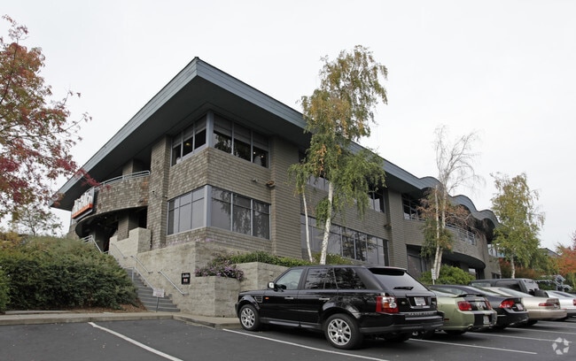
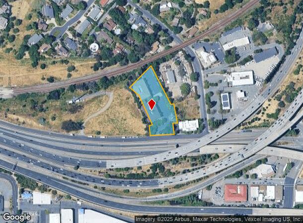
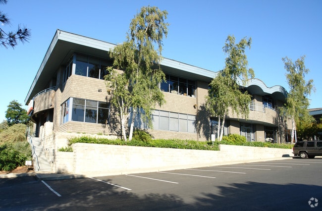
Property Record
2520 Camino Diablo, Walnut Creek, CA 94597

Current Lease Availabilities
NEARBY LISTINGS FOR SALE OR LEASE
Property Detail
2520 Camino Diablo
Oakland-Hayward-Berkeley, CA
Del Hambre Terrace
177-200-005-3
DEL HAMBRE TERRACE POR LOTS 53 & 54
Officebuilding
Contra Costa
X
California
06013C0289G
53,54
2024
1.49 AC
2025
Walnut Creek-BART/DT
340004
East Bay/Oakland
12,479 SF
DEMOGRAPHICS near 2520 Camino Diablo
1 Mile
3 Mile
5 Mile
2024 Total Population
14,690
104,087
203,328
2029 Population
14,701
103,816
202,175
Pop Growth 2024-2029
+ 0.07%
(0.26%)
(0.57%)
Average Age
43
45
44
2024 Total Households
6,594
46,561
83,058
HH Growth 2024-2029
+ 0.26%
(0.18%)
(0.49%)
Median Household Inc
$132,573
$131,553
$137,672
Avg Household Size
2.20
2.20
2.40
2024 Avg HH Vehicles
2.00
2.00
2.00
Median Home Value
$1,091,244
$1,046,245
$1,043,342
Median Year Built
1972
1972
1971
Nearby Places
- Restaurants
- Banks
- Shops
- Fitness
- Groceries
PUBLIC TRANSPORTATION
TRANSIT/SUBWAY
Walnut Creek Station (Antioch to SFIA/Millbrae - Bay Area Rapid Transit (BART), Millbrae/SFIA to Antioch - Bay Area Rapid Transit (BART), Pittsburg/Bay Point - San Francisco International - Bay Area Rapid Transit (BART))
DRIVE
WALK
Distance
Walnut Creek Station (Antioch to SFIA/Millbrae - Bay Area Rapid Transit (BART), Millbrae/SFIA to Antioch - Bay Area Rapid Transit (BART), Pittsburg/Bay Point - San Francisco International - Bay Area Rapid Transit (BART))
4 min
19 min
1.0 mi
AIRPORT
Metro Oakland International
DRIVE
WALK
Distance
Metro Oakland International
32 min
23.2 mi
San Francisco International
DRIVE
WALK
Distance
San Francisco International
50 min
35.2 mi
Freight Ports
Port of Oakland
DRIVE
WALK
Distance
Port of Oakland
22 min
16.0 mi
Nearby Properties
Address
Land Use
TOTAL SIZE
Lot Size
Zoning
Address
Land Use
TOTAL SIZE
Lot Size
Zoning
Address
Land Use
TOTAL SIZE
Lot Size
Zoning
13.66 AC
Address
Land Use
TOTAL SIZE
Lot Size
Zoning
428,476 SF
3.56 AC
Address
Land Use
TOTAL SIZE
Lot Size
Zoning
155,176 SF
3.34 AC
Address
Land Use
TOTAL SIZE
Lot Size
Zoning
213,500 SF
3.02 AC
Address
Land Use
TOTAL SIZE
Lot Size
Zoning
337,980 SF
5.08 AC
Address
Land Use
TOTAL SIZE
Lot Size
Zoning
254,940 SF
1.61 AC
P1
Address
Land Use
TOTAL SIZE
Lot Size
Zoning
77,286 SF
3.68 AC
Address
Land Use
TOTAL SIZE
Lot Size
Zoning
232,529 SF
3.76 AC
M12
Address
Land Use
TOTAL SIZE
Lot Size
Zoning
174,951 SF
1.82 AC
Address
Land Use
TOTAL SIZE
Lot Size
Zoning
264,873 SF
2.19 AC
P1
Address
Land Use
TOTAL SIZE
Lot Size
Zoning
5.52 AC
P1
Address
Land Use
TOTAL SIZE
Lot Size
Zoning
235,495 SF
2.51 AC
P1
Address
Land Use
TOTAL SIZE
Lot Size
Zoning
250,032 SF
7.95 AC
P1
Address
Land Use
TOTAL SIZE
Lot Size
Zoning
153,137 SF
1.22 AC
Address
Land Use
TOTAL SIZE
Lot Size
Zoning
393,680 SF
2.29 AC
Address
Land Use
TOTAL SIZE
Lot Size
Zoning
157,352 SF
0.98 AC
Address
Land Use
TOTAL SIZE
Lot Size
Zoning
249,628 SF
3.64 AC
P1
Address
Land Use
TOTAL SIZE
Lot Size
Zoning
118,596 SF
1.20 AC
Address
Land Use
TOTAL SIZE
Lot Size
Zoning
800,764 SF
3.66 AC
Address
Land Use
TOTAL SIZE
Lot Size
Zoning
192,387 SF
17.42 AC
M17
Address
Land Use
TOTAL SIZE
Lot Size
Zoning
12,864 SF
5.62 AC
Address
Land Use
TOTAL SIZE
Lot Size
Zoning
187,156 SF
5.92 AC
P1
Address
Land Use
TOTAL SIZE
Lot Size
Zoning
24,392 SF
2.29 AC
Address
Land Use
TOTAL SIZE
Lot Size
Zoning
321,000 SF
3.26 AC
Address
Land Use
TOTAL SIZE
Lot Size
Zoning
38,027 SF
2.86 AC
Address
Land Use
TOTAL SIZE
Lot Size
Zoning
237,656 SF
7.16 AC
P1
Address
Land Use
TOTAL SIZE
Lot Size
Zoning
3,546 SF
3.71 AC
Address
Land Use
TOTAL SIZE
Lot Size
Zoning
22,770 SF
1.32 AC
Address
Land Use
TOTAL SIZE
Lot Size
Zoning
13,326 SF
6.84 AC
M-H
The World's #1 Commercial Real Estate Marketplace
Connect with us
© 2025 CoStar Group
The information above has been obtained from sources believed reliable. While we do not doubt its accuracy we have not verified it and make no guarantee, warranty or representation about it. It is your responsibility to independently confirm its accuracy and completeness. Any projections, opinions, assumptions, or estimates used are for example only and do not represent the current or future performance of the property. The value of this transaction to you depends on tax and other factors which should be evaluated by your tax, financial, and legal advisors. You and your advisors should conduct a careful, independent investigation of the property to determine to your satisfaction the suitability of the property for your needs.