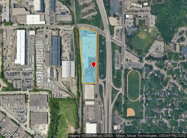
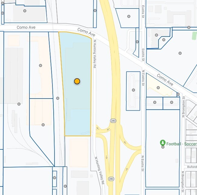
Property Record
2520 Como Ave, Saint Paul, MN 55108

NEARBY LISTINGS FOR SALE OR LEASE
Property Detail
2520 Como Ave
20-29-23-23-0005
Section 20 Town 29 Range 23
Publicstorage
SECTION 20 TOWN 29 RANGE 23 SUBJ TO POWER ESMT AND EX S 291 42/1OO ...OF STH 28O IN SEC 20 TN 29 RN 23
X
Ramsey
27053C0377F
Minnesota
2024
6.23 AC
2025
Midway
030100
Minneapolis/St Paul
178,175 SF
Minneapolis-St. Paul-Bloomington, MN-WI
DEMOGRAPHICS near 2520 Como Ave
1 Mile
3 Mile
5 Mile
2024 Total Population
9,123
151,546
480,917
2029 Population
8,870
148,793
472,837
Pop Growth 2024-2029
(2.77%)
(1.82%)
(1.68%)
Average Age
36
36
37
2024 Total Households
3,786
65,813
208,434
HH Growth 2024-2029
(3.04%)
(1.87%)
(1.67%)
Median Household Inc
$73,095
$63,861
$66,996
Avg Household Size
2.30
2.10
2.10
2024 Avg HH Vehicles
2.00
1.00
1.00
Median Home Value
$357,875
$338,712
$314,343
Median Year Built
1959
1968
1959
Nearby Places
Map Layers
Map Styles
 Street
 Aerial
- Restaurants
- Banks
- Shops
- Fitness
- Groceries
PUBLIC TRANSPORTATION
COMMUTER RAIL
Target Field Station (Northstar Corridor - Northstar Commuter Rail)
DRIVE
WALK
Distance
Target Field Station (Northstar Corridor - Northstar Commuter Rail)
13 min
4.5 mi
St. Paul-Minneapolis (Empire Builder - Amtrak)
DRIVE
WALK
Distance
St. Paul-Minneapolis (Empire Builder - Amtrak)
13 min
8.1 mi
AIRPORT
Minneapolis-St Paul International/Wold-Chamberlain
DRIVE
WALK
Distance
Minneapolis-St Paul International/Wold-Chamberlain
21 min
10.9 mi
Freight Ports
Port Milwaukee
DRIVE
WALK
Distance
Port Milwaukee
372 min
336.4 mi
Nearby Properties
Address
Land Use
TOTAL SIZE
Lot Size
Zoning
Address
Land Use
TOTAL SIZE
Lot Size
Zoning
36,300 SF
223.37 AC
Address
Land Use
TOTAL SIZE
Lot Size
Zoning
Address
Land Use
TOTAL SIZE
Lot Size
Zoning
124,932 SF
9.68 AC
Address
Land Use
TOTAL SIZE
Lot Size
Zoning
495,632 SF
1.72 AC
C1
Address
Land Use
TOTAL SIZE
Lot Size
Zoning
695,624 SF
3.67 AC
C2
Address
Land Use
TOTAL SIZE
Lot Size
Zoning
615,172 SF
1.98 AC
I1
Address
Land Use
TOTAL SIZE
Lot Size
Zoning
37.24 AC
Address
Land Use
TOTAL SIZE
Lot Size
Zoning
577,656 SF
2.92 AC
C3A
Address
Land Use
TOTAL SIZE
Lot Size
Zoning
557,654 SF
3.15 AC
C2
Address
Land Use
TOTAL SIZE
Lot Size
Zoning
478,616 SF
2.28 AC
C2
Address
Land Use
TOTAL SIZE
Lot Size
Zoning
513,403 SF
0.73 AC
C2
Address
Land Use
TOTAL SIZE
Lot Size
Zoning
403,792 SF
2.51 AC
B4N
Address
Land Use
TOTAL SIZE
Lot Size
Zoning
18.24 AC
Address
Land Use
TOTAL SIZE
Lot Size
Zoning
618,841 SF
1.53 AC
B4N
Address
Land Use
TOTAL SIZE
Lot Size
Zoning
618,841 SF
1.54 AC
B4S-2
Address
Land Use
TOTAL SIZE
Lot Size
Zoning
294,047 SF
7.99 AC
Address
Land Use
TOTAL SIZE
Lot Size
Zoning
401,175 SF
0.75 AC
B4N
Address
Land Use
TOTAL SIZE
Lot Size
Zoning
393,881 SF
1.10 AC
B4-1
Address
Land Use
TOTAL SIZE
Lot Size
Zoning
546,882 SF
2.64 AC
R6
Address
Land Use
TOTAL SIZE
Lot Size
Zoning
344,458 SF
1.64 AC
C3A
Address
Land Use
TOTAL SIZE
Lot Size
Zoning
321,828 SF
0.77 AC
I1
Address
Land Use
TOTAL SIZE
Lot Size
Zoning
423,037 SF
0.28 AC
C3A
Address
Land Use
TOTAL SIZE
Lot Size
Zoning
3,200 SF
0.14 AC
Address
Land Use
TOTAL SIZE
Lot Size
Zoning
4,808 SF
269.81 AC
Address
Land Use
TOTAL SIZE
Lot Size
Zoning
68,748 SF
21.59 AC
Address
Land Use
TOTAL SIZE
Lot Size
Zoning
379,292 SF
5.53 AC
C3A
Address
Land Use
TOTAL SIZE
Lot Size
Zoning
522,282 SF
2.88 AC
B4S-1
Address
Land Use
TOTAL SIZE
Lot Size
Zoning
295,982 SF
2.51 AC
B4S-2
Address
Land Use
TOTAL SIZE
Lot Size
Zoning
18,630 SF
22.02 AC
Address
Land Use
TOTAL SIZE
Lot Size
Zoning
518,750 SF
3.58 AC
The World's #1 Commercial Real Estate Marketplace
Connect with us
© 2025 CoStar Group
The information above has been obtained from sources believed reliable. While we do not doubt its accuracy we have not verified it and make no guarantee, warranty or representation about it. It is your responsibility to independently confirm its accuracy and completeness. Any projections, opinions, assumptions, or estimates used are for example only and do not represent the current or future performance of the property. The value of this transaction to you depends on tax and other factors which should be evaluated by your tax, financial, and legal advisors. You and your advisors should conduct a careful, independent investigation of the property to determine to your satisfaction the suitability of the property for your needs.