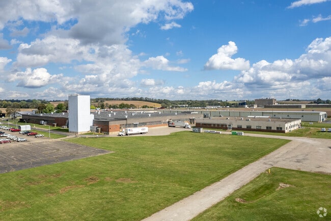
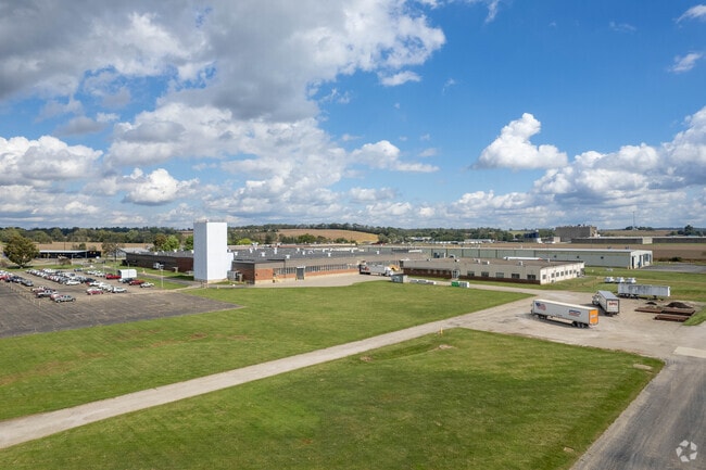
Property Record
2520 E Main St, Lancaster, OH 43130
Property Detail
2520 E Main St
05-35002-600
R 18 T 14 S 3 NW 13.93A HIGHWAY EASEMENT .31A
Industrialgeneral
FAIRFIELD
B and X Area of moderate flood hazard, usually the area between the limits of the 100-year and 500-year floods.
Ohio
2024
37.28 AC
2025
Fairfield County
032000
Columbus
511,305 SF
Columbus, OH
NEARBY LISTINGS FOR SALE OR LEASE
-
-
View all Lancaster listings for sale on LoopNet.com
DEMOGRAPHICS near 2520 E Main St
1 mile
3 mile
5 mile
2025 Total Population
620
16,397
44,765
2030 Population
642
17,175
46,960
Pop Growth 2025-2030
+ 3.55%
+ 4.74%
+ 4.90%
Average Age
41
42
41
2025 Total Households
222
6,899
18,340
HH Growth 2025-2030
+ 3.60%
+ 4.94%
+ 5.11%
Median Household Inc
$54,000
$66,659
$63,422
Avg Household Size
2.70
2.30
2.40
2025 Avg HH Vehicles
2.00
2.00
2.00
Median Home Value
$351,785
$232,347
$201,709
Median Year Built
1975
1965
1960
Nearby Places
Map Layers
Map Styles
 Street
 Aerial
Transit
 Traffic
 Biking
Places
Listings with unknown addresses are not visible on the map
- Restaurants
- Banks
- Shops
- Fitness
- Groceries
PUBLIC TRANSPORTATION
AIRPORT
Rickenbacker International
Drive
Walk
Distance
Rickenbacker International
45 min
30.9 mi
John Glenn Columbus International
Drive
Walk
Distance
John Glenn Columbus International
48 min
34.0 mi
Freight Ports
Port of Toledo
Drive
Walk
Distance
Port of Toledo
225 min
182.9 mi
Nearby Properties
Address
Land Use
TOTAL SIZE
Lot Size
Zoning
Address
Land Use
TOTAL SIZE
Lot Size
Zoning
519,532 SF
9.92 AC
Address
Land Use
TOTAL SIZE
Lot Size
Zoning
88,522 SF
36.77 AC
Address
Land Use
TOTAL SIZE
Lot Size
Zoning
141,894 SF
68.74 AC
Address
Land Use
TOTAL SIZE
Lot Size
Zoning
61,657 SF
10.45 AC
Address
Land Use
TOTAL SIZE
Lot Size
Zoning
29,579 SF
6.77 AC
Address
Land Use
TOTAL SIZE
Lot Size
Zoning
421,760 SF
55.76 AC
Address
Land Use
TOTAL SIZE
Lot Size
Zoning
91,478 SF
11.98 AC
Address
Land Use
TOTAL SIZE
Lot Size
Zoning
49,353 SF
15.01 AC
Address
Land Use
TOTAL SIZE
Lot Size
Zoning
128,515 SF
11.84 AC
Address
Land Use
TOTAL SIZE
Lot Size
Zoning
63,241 SF
4.37 AC
Address
Land Use
TOTAL SIZE
Lot Size
Zoning
280,714 SF
34.65 AC
Address
Land Use
TOTAL SIZE
Lot Size
Zoning
45,000 SF
0.72 AC
Address
Land Use
TOTAL SIZE
Lot Size
Zoning
92,228 SF
5.20 AC
Address
Land Use
TOTAL SIZE
Lot Size
Zoning
33,550 SF
6.15 AC
Address
Land Use
TOTAL SIZE
Lot Size
Zoning
126,068 SF
15.73 AC
Address
Land Use
TOTAL SIZE
Lot Size
Zoning
55,200 SF
5.11 AC
Address
Land Use
TOTAL SIZE
Lot Size
Zoning
52,468 SF
10 AC
Address
Land Use
TOTAL SIZE
Lot Size
Zoning
24,259 SF
36.11 AC
Address
Land Use
TOTAL SIZE
Lot Size
Zoning
223,927 SF
17.35 AC
Address
Land Use
TOTAL SIZE
Lot Size
Zoning
4,787 SF
10.76 AC
Address
Land Use
TOTAL SIZE
Lot Size
Zoning
23,827 SF
2.89 AC
Address
Land Use
TOTAL SIZE
Lot Size
Zoning
155,123 SF
18.82 AC
Address
Land Use
TOTAL SIZE
Lot Size
Zoning
12,576 SF
7.91 AC
Address
Land Use
TOTAL SIZE
Lot Size
Zoning
98,348 SF
13.05 AC
Address
Land Use
TOTAL SIZE
Lot Size
Zoning
31,438 SF
9.54 AC
Address
Land Use
TOTAL SIZE
Lot Size
Zoning
14,101 SF
12.14 AC
Address
Land Use
TOTAL SIZE
Lot Size
Zoning
321,774 SF
56.25 AC
Address
Land Use
TOTAL SIZE
Lot Size
Zoning
43,300 SF
3.94 AC
Address
Land Use
TOTAL SIZE
Lot Size
Zoning
54,544 SF
19.01 AC
The World's #1 Commercial Real Estate Marketplace
Connect with us
© 2026 CoStar Group
The information above has been obtained from sources believed reliable. While we do not doubt its accuracy we have not verified it and make no guarantee, warranty or representation about it. It is your responsibility to independently confirm its accuracy and completeness. Any projections, opinions, assumptions, or estimates used are for example only and do not represent the current or future performance of the property. The value of this transaction to you depends on tax and other factors which should be evaluated by your tax, financial, and legal advisors. You and your advisors should conduct a careful, independent investigation of the property to determine to your satisfaction the suitability of the property for your needs.