Property Record
2520 N River Rd, Olathe, CO 81425
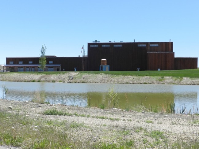

This Property Is For Sale
Current Lease Availabilities
Property Detail
2520 N River Rd
R0651968
S: 28 T: 51 R: 10 A PARCEL OF LAND LOC IN SEC 28 DESC BY M/B RECPT #845141; ALSO SHOWN ON PLAT OF SURVEY RECPT #843824
Warehouse
Montrose
B and X Area of moderate flood hazard, usually the area between the limits of the 100-year and 500-year floods.
Colorado
2025
42.59 AC
2025
Colorado Southwest Area
966201
Other Market Areas
76,442 SF
Montrose, CO
NEARBY LISTINGS FOR SALE OR LEASE
DEMOGRAPHICS near 2520 N River Rd
1 mile
3 mile
5 mile
2025 Total Population
75
1,091
5,723
2030 Population
80
1,139
5,898
Pop Growth 2025-2030
+ 6.67%
+ 4.40%
+ 3.06%
Average Age
44
43
42
2025 Total Households
27
398
2,039
HH Growth 2025-2030
+ 7.41%
+ 4.52%
+ 3.29%
Median Household Inc
$74,999
$76,786
$76,365
Avg Household Size
2.50
2.60
2.60
2025 Avg HH Vehicles
3.00
3.00
2.00
Median Home Value
$562,500
$454,687
$382,417
Median Year Built
1996
1995
1991
Nearby Places
Map Layers
Map Styles
 Street
 Aerial
Transit
 Traffic
 Biking
Places
Listings with unknown addresses are not visible on the map
- Restaurants
- Banks
- Shops
- Fitness
- Groceries
PUBLIC TRANSPORTATION
AIRPORT
Montrose Regional
Drive
Walk
Distance
Montrose Regional
20 min
12.0 mi
Nearby Properties
Address
Land Use
TOTAL SIZE
Lot Size
Zoning
Address
Land Use
TOTAL SIZE
Lot Size
Zoning
8,898 SF
9.88 AC
Address
Land Use
TOTAL SIZE
Lot Size
Zoning
13,720 SF
2.28 AC
Address
Land Use
TOTAL SIZE
Lot Size
Zoning
8,965 SF
2 AC
Address
Land Use
TOTAL SIZE
Lot Size
Zoning
40,056 SF
6.10 AC
Address
Land Use
TOTAL SIZE
Lot Size
Zoning
7,600 SF
11.68 AC
Address
Land Use
TOTAL SIZE
Lot Size
Zoning
2,400 SF
98.78 AC
Address
Land Use
TOTAL SIZE
Lot Size
Zoning
6,600 SF
22.04 AC
Address
Land Use
TOTAL SIZE
Lot Size
Zoning
5,000 SF
5.97 AC
Address
Land Use
TOTAL SIZE
Lot Size
Zoning
25,826 SF
363.18 AC
Address
Land Use
TOTAL SIZE
Lot Size
Zoning
2,400 SF
1.10 AC
Address
Land Use
TOTAL SIZE
Lot Size
Zoning
3,840 SF
2.90 AC
Address
Land Use
TOTAL SIZE
Lot Size
Zoning
2,400 SF
2.99 AC
Address
Land Use
TOTAL SIZE
Lot Size
Zoning
6,270 SF
13.70 AC
Address
Land Use
TOTAL SIZE
Lot Size
Zoning
1,441 SF
1.35 AC
Address
Land Use
TOTAL SIZE
Lot Size
Zoning
Address
Land Use
TOTAL SIZE
Lot Size
Zoning
5,167 SF
110.35 AC
Address
Land Use
TOTAL SIZE
Lot Size
Zoning
800 SF
38.75 AC
Address
Land Use
TOTAL SIZE
Lot Size
Zoning
3,750 SF
40.03 AC
Address
Land Use
TOTAL SIZE
Lot Size
Zoning
4,228 SF
6.53 AC
Address
Land Use
TOTAL SIZE
Lot Size
Zoning
1,120 SF
3.75 AC
Address
Land Use
TOTAL SIZE
Lot Size
Zoning
1,208 SF
67.03 AC
Address
Land Use
TOTAL SIZE
Lot Size
Zoning
854 SF
50 AC
Address
Land Use
TOTAL SIZE
Lot Size
Zoning
1,721 SF
79.90 AC
Address
Land Use
TOTAL SIZE
Lot Size
Zoning
8.58 AC
Address
Land Use
TOTAL SIZE
Lot Size
Zoning
1,470 SF
60.35 AC
Address
Land Use
TOTAL SIZE
Lot Size
Zoning
41.12 AC
Address
Land Use
TOTAL SIZE
Lot Size
Zoning
2,297 SF
22.05 AC
Address
Land Use
TOTAL SIZE
Lot Size
Zoning
5,851 SF
81.57 AC
Address
Land Use
TOTAL SIZE
Lot Size
Zoning
4.64 AC
The World's #1 Commercial Real Estate Marketplace
Connect with us
© 2026 CoStar Group
The information above has been obtained from sources believed reliable. While we do not doubt its accuracy we have not verified it and make no guarantee, warranty or representation about it. It is your responsibility to independently confirm its accuracy and completeness. Any projections, opinions, assumptions, or estimates used are for example only and do not represent the current or future performance of the property. The value of this transaction to you depends on tax and other factors which should be evaluated by your tax, financial, and legal advisors. You and your advisors should conduct a careful, independent investigation of the property to determine to your satisfaction the suitability of the property for your needs.