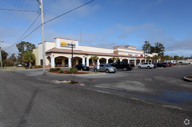
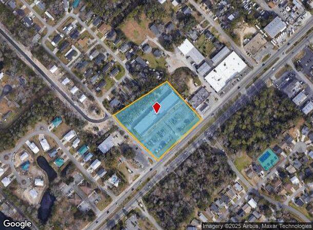
Property Record
2520 S Highway 17, Murrells Inlet, SC 29576
NEARBY LISTINGS FOR SALE OR LEASE
Property Detail
2520 S Highway 17
Myrtle Beach-Conway-North Myrtle Beach, SC-NC
Jamestown
46215020020
HWY 17 & JAMESTOWN; DR/LOTS 1 & 2
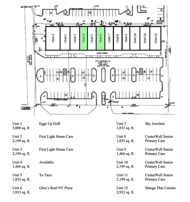
Medicalbuilding
Horry
X
South Carolina
45043C0250G
1-2
2025
3.29 AC
2024
Outlying Horry County
051405
Myrtle Beach/Conway
14,752 SF
DEMOGRAPHICS near 2520 S Highway 17
1 Mile
3 Mile
5 Mile
2024 Total Population
8,402
40,918
76,969
2029 Population
10,492
50,083
92,594
Pop Growth 2024-2029
+ 24.88%
+ 22.40%
+ 20.30%
Average Age
56
52
51
2024 Total Households
4,306
19,478
35,564
HH Growth 2024-2029
+ 23.53%
+ 21.22%
+ 19.24%
Median Household Inc
$52,009
$57,993
$60,467
Avg Household Size
1.90
2.00
2.10
2024 Avg HH Vehicles
2.00
2.00
2.00
Median Home Value
$208,749
$244,882
$247,403
Median Year Built
1989
1993
1997
Nearby Places
Map Layers
Map Styles
 Street
 Aerial
- Restaurants
- Banks
- Shops
- Fitness
- Groceries
PUBLIC TRANSPORTATION
AIRPORT
Myrtle Beach International
DRIVE
WALK
Distance
Myrtle Beach International
19 min
9.6 mi
Freight Ports
Wando Welch Terminal
DRIVE
WALK
Distance
Wando Welch Terminal
105 min
79.1 mi
SALE & LEASE HISTORY
LISTING DATE
SALE/LEASE

Sep 27, 2018
For Lease
Oct 20, 2020
For Lease
Nov 21, 2016
For Lease
Jun 08, 2017
For Lease
Dec 12, 2017
For Lease
Dec 11, 2018
For Lease
Nearby Properties
Address
Land Use
TOTAL SIZE
Lot Size
Zoning
Address
Land Use
TOTAL SIZE
Lot Size
Zoning
9,772 SF
130.49 AC
Address
Land Use
TOTAL SIZE
Lot Size
Zoning
3,696 SF
55.20 AC
Address
Land Use
TOTAL SIZE
Lot Size
Zoning
17,408 SF
1.97 AC
Address
Land Use
TOTAL SIZE
Lot Size
Zoning
7,144 SF
187.64 AC
Address
Land Use
TOTAL SIZE
Lot Size
Zoning
151,727 SF
21.25 AC
Address
Land Use
TOTAL SIZE
Lot Size
Zoning
10,532 SF
2.90 AC
Address
Land Use
TOTAL SIZE
Lot Size
Zoning
2,510 SF
43.14 AC
Address
Land Use
TOTAL SIZE
Lot Size
Zoning
6,170 SF
2.50 AC
Address
Land Use
TOTAL SIZE
Lot Size
Zoning
Address
Land Use
TOTAL SIZE
Lot Size
Zoning
25,722 SF
13.73 AC
Address
Land Use
TOTAL SIZE
Lot Size
Zoning
4,800 SF
75.54 AC
Address
Land Use
TOTAL SIZE
Lot Size
Zoning
65,578 SF
12.12 AC
Address
Land Use
TOTAL SIZE
Lot Size
Zoning
33,862 SF
9.98 AC
Address
Land Use
TOTAL SIZE
Lot Size
Zoning
28,278 SF
50.53 AC
Address
Land Use
TOTAL SIZE
Lot Size
Zoning
64,620 SF
7.90 AC
Address
Land Use
TOTAL SIZE
Lot Size
Zoning
8,012 SF
7.40 AC
Address
Land Use
TOTAL SIZE
Lot Size
Zoning
74,389 SF
1.90 AC
Address
Land Use
TOTAL SIZE
Lot Size
Zoning
49.53 AC
Address
Land Use
TOTAL SIZE
Lot Size
Zoning
6,728 SF
35.71 AC
Address
Land Use
TOTAL SIZE
Lot Size
Zoning
Address
Land Use
TOTAL SIZE
Lot Size
Zoning
108,250 SF
14.53 AC
Address
Land Use
TOTAL SIZE
Lot Size
Zoning
8,640 SF
5.47 AC
Address
Land Use
TOTAL SIZE
Lot Size
Zoning
80,797 SF
33.77 AC
Address
Land Use
TOTAL SIZE
Lot Size
Zoning
69,048 SF
12.59 AC
Address
Land Use
TOTAL SIZE
Lot Size
Zoning
12.71 AC
Address
Land Use
TOTAL SIZE
Lot Size
Zoning
93,048 SF
2.24 AC
Address
Land Use
TOTAL SIZE
Lot Size
Zoning
101,152 SF
2.35 AC
The World's #1 Commercial Real Estate Marketplace
Connect with us
© 2025 CoStar Group
The information above has been obtained from sources believed reliable. While we do not doubt its accuracy we have not verified it and make no guarantee, warranty or representation about it. It is your responsibility to independently confirm its accuracy and completeness. Any projections, opinions, assumptions, or estimates used are for example only and do not represent the current or future performance of the property. The value of this transaction to you depends on tax and other factors which should be evaluated by your tax, financial, and legal advisors. You and your advisors should conduct a careful, independent investigation of the property to determine to your satisfaction the suitability of the property for your needs.