Property Record
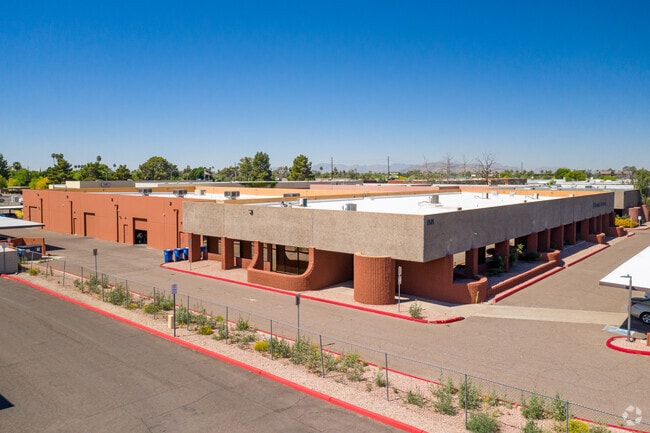
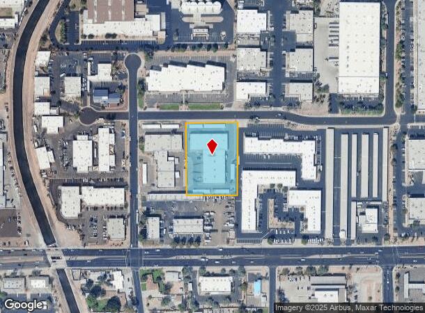
2521 W Birchwood Ave, Mesa, AZ 85202

This Property Is For Sale
NEARBY LISTINGS FOR SALE OR LEASE
Property Detail
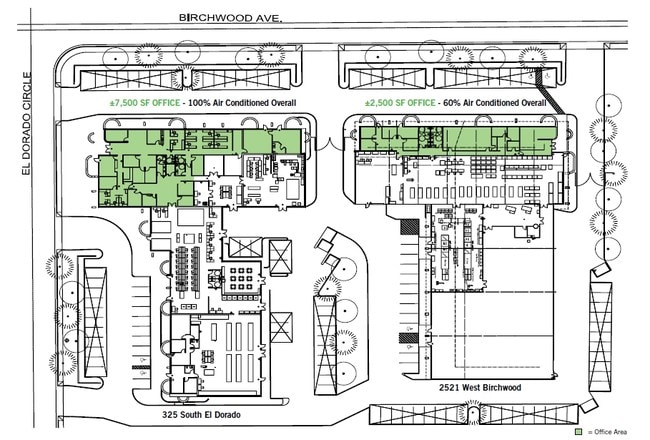
2521 W Birchwood Ave
Phoenix-Mesa-Scottsdale, AZ
Broadway Business Park
134-36-008
BROADWAY BUSINESS PARK MCR 229-24
Warehouse
Maricopa
X
Arizona
04013C2245L
4
2025
1.77 AC
2025
Mesa
421304
Phoenix
28,454 SF
DEMOGRAPHICS near 2521 W Birchwood Ave
1 Mile
3 Mile
5 Mile
2024 Total Population
21,098
161,041
379,755
2029 Population
22,795
173,616
410,429
Pop Growth 2024-2029
+ 8.04%
+ 7.81%
+ 8.08%
Average Age
35
34
36
2024 Total Households
9,129
65,539
153,004
HH Growth 2024-2029
+ 8.16%
+ 8.17%
+ 8.34%
Median Household Inc
$47,737
$54,361
$61,181
Avg Household Size
2.20
2.30
2.30
2024 Avg HH Vehicles
2.00
2.00
2.00
Median Home Value
$302,046
$329,829
$342,353
Median Year Built
1979
1980
1980
Nearby Places
Map Layers
Map Styles
 Street
 Aerial
- Restaurants
- Banks
- Shops
- Fitness
- Groceries
PUBLIC TRANSPORTATION
TRANSIT/SUBWAY
Price-101 Fwy/Apache Blvd (METRO Light Rail - Valley Metro (Phoenix Light Rail))
DRIVE
WALK
Distance
Price-101 Fwy/Apache Blvd (METRO Light Rail - Valley Metro (Phoenix Light Rail))
2 min
19 min
1.0 mi
AIRPORT
Phoenix Sky Harbor International
DRIVE
WALK
Distance
Phoenix Sky Harbor International
15 min
9.2 mi
Phoenix-Mesa Gateway
DRIVE
WALK
Distance
Phoenix-Mesa Gateway
31 min
19.9 mi
Freight Ports
Port of San Diego
DRIVE
WALK
Distance
Port of San Diego
406 min
370.9 mi
Nearby Properties
Address
Land Use
TOTAL SIZE
Lot Size
Zoning
Address
Land Use
TOTAL SIZE
Lot Size
Zoning
439,211 SF
77.92 AC
C-G
Address
Land Use
TOTAL SIZE
Lot Size
Zoning
918,576 SF
22.96 AC
C-N
Address
Land Use
TOTAL SIZE
Lot Size
Zoning
401,544 SF
64.59 AC
GID
Address
Land Use
TOTAL SIZE
Lot Size
Zoning
1,227,029 SF
7.39 AC
R-6
Address
Land Use
TOTAL SIZE
Lot Size
Zoning
5.13 AC
Address
Land Use
TOTAL SIZE
Lot Size
Zoning
1,102,629 SF
12.33 AC
R-3
Address
Land Use
TOTAL SIZE
Lot Size
Zoning
2.54 AC
Address
Land Use
TOTAL SIZE
Lot Size
Zoning
805,814 SF
115.19 AC
C-G
Address
Land Use
TOTAL SIZE
Lot Size
Zoning
571,804 SF
0.98 AC
CSS
Address
Land Use
TOTAL SIZE
Lot Size
Zoning
8.79 AC
PF
Address
Land Use
TOTAL SIZE
Lot Size
Zoning
197,454 SF
18.97 AC
PF
Address
Land Use
TOTAL SIZE
Lot Size
Zoning
352,244 SF
5.55 AC
R-6
Address
Land Use
TOTAL SIZE
Lot Size
Zoning
368,727 SF
12.77 AC
R1-6
Address
Land Use
TOTAL SIZE
Lot Size
Zoning
654,960 SF
19.48 AC
R-6
Address
Land Use
TOTAL SIZE
Lot Size
Zoning
544,646 SF
1.65 AC
MU4
Address
Land Use
TOTAL SIZE
Lot Size
Zoning
401,437 SF
17.70 AC
C-R
Address
Land Use
TOTAL SIZE
Lot Size
Zoning
474,335 SF
9.54 AC
R-3
Address
Land Use
TOTAL SIZE
Lot Size
Zoning
640,230 SF
3.94 AC
MU4
Address
Land Use
TOTAL SIZE
Lot Size
Zoning
683,623 SF
1.80 AC
PAD
Address
Land Use
TOTAL SIZE
Lot Size
Zoning
937,488 SF
40.63 AC
R-4
Address
Land Use
TOTAL SIZE
Lot Size
Zoning
420,534 SF
1.62 AC
PAD
Address
Land Use
TOTAL SIZE
Lot Size
Zoning
564,649 SF
7.19 AC
RCC
Address
Land Use
TOTAL SIZE
Lot Size
Zoning
448,308 SF
6.30 AC
GID
Address
Land Use
TOTAL SIZE
Lot Size
Zoning
1,107,057 SF
2.38 AC
PAD
Address
Land Use
TOTAL SIZE
Lot Size
Zoning
267,023 SF
19.58 AC
PEP
Address
Land Use
TOTAL SIZE
Lot Size
Zoning
573,715 SF
3.37 AC
MU4
Address
Land Use
TOTAL SIZE
Lot Size
Zoning
459,103 SF
13.27 AC
MU4
Address
Land Use
TOTAL SIZE
Lot Size
Zoning
562,356 SF
6.70 AC
MU4
The World's #1 Commercial Real Estate Marketplace
Connect with us
© 2026 CoStar Group
The information above has been obtained from sources believed reliable. While we do not doubt its accuracy we have not verified it and make no guarantee, warranty or representation about it. It is your responsibility to independently confirm its accuracy and completeness. Any projections, opinions, assumptions, or estimates used are for example only and do not represent the current or future performance of the property. The value of this transaction to you depends on tax and other factors which should be evaluated by your tax, financial, and legal advisors. You and your advisors should conduct a careful, independent investigation of the property to determine to your satisfaction the suitability of the property for your needs.