Property Record
2512 Chambers Rd, Tustin, CA 92780
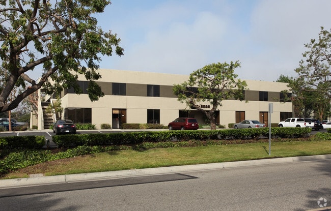


Property Detail
2512 Chambers Rd
432-471-21
P BK 84 PG 35 PAR 2
Commercialnec
ORANGE
M
California
C and X Area of minimal flood hazard, usually depicted on FIRMs as above the 500-year flood level.
2
2024
1.68 AC
2025
Tustin (South of I-5)
052502
Orange County (California)
32,680 SF
Anaheim-Santa Ana-Irvine, CA
NEARBY LISTINGS FOR SALE OR LEASE
DEMOGRAPHICS near 2512 Chambers Rd
1 mile
3 mile
5 mile
2025 Total Population
18,048
213,229
555,381
2030 Population
18,379
214,007
556,041
Pop Growth 2025-2030
+ 1.83%
+ 0.36%
+ 0.12%
Average Age
40
39
38
2025 Total Households
6,126
73,631
181,352
HH Growth 2025-2030
+ 2.20%
+ 0.40%
+ 0.22%
Median Household Inc
$113,636
$116,343
$112,543
Avg Household Size
2.90
2.80
2.90
2025 Avg HH Vehicles
2.00
2.00
2.00
Median Home Value
$827,659
$1,032,121
$1,003,763
Median Year Built
1978
1984
1983
Nearby Places
Map Layers
Map Styles
 Street
 Aerial
Transit
 Traffic
 Biking
Places
Listings with unknown addresses are not visible on the map
- Restaurants
- Banks
- Shops
- Fitness
- Groceries
PUBLIC TRANSPORTATION
COMMUTER RAIL
Tustin (Inland Empire-Orange County Line - Southern California Regional Rail Authority (Metrolink), Orange County Line - Southern California Regional Rail Authority (Metrolink))
Drive
Walk
Distance
Tustin (Inland Empire-Orange County Line - Southern California Regional Rail Authority (Metrolink), Orange County Line - Southern California Regional Rail Authority (Metrolink))
3 min
20 min
1.0 mi
Santa Ana (Inland Empire-Orange County Line - Southern California Regional Rail Authority (Metrolink), Orange County Line - Southern California Regional Rail Authority (Metrolink))
Drive
Walk
Distance
Santa Ana (Inland Empire-Orange County Line - Southern California Regional Rail Authority (Metrolink), Orange County Line - Southern California Regional Rail Authority (Metrolink))
9 min
5.3 mi
AIRPORT
John Wayne/Orange County
Drive
Walk
Distance
John Wayne/Orange County
11 min
7.2 mi
Long Beach (Daugherty Field)
Drive
Walk
Distance
Long Beach (Daugherty Field)
33 min
26.1 mi
Ontario International
Drive
Walk
Distance
Ontario International
47 min
34.2 mi
Freight Ports
Port of Long Beach
Drive
Walk
Distance
Port of Long Beach
37 min
25.6 mi
SALE & LEASE HISTORY
LISTING DATE
SALE/LEASE

Sep 13, 2017
For Lease
Nov 20, 2020
For Lease
May 03, 2017
For Lease
Jul 01, 2021
For Lease
Apr 18, 2017
For Lease
Nearby Properties
Address
Land Use
TOTAL SIZE
Lot Size
Zoning
Address
Land Use
TOTAL SIZE
Lot Size
Zoning
28.01 AC
Address
Land Use
TOTAL SIZE
Lot Size
Zoning
15.99 AC
Address
Land Use
TOTAL SIZE
Lot Size
Zoning
5.11 AC
Address
Land Use
TOTAL SIZE
Lot Size
Zoning
9.44 AC
Address
Land Use
TOTAL SIZE
Lot Size
Zoning
24,680 SF
3.63 AC
Address
Land Use
TOTAL SIZE
Lot Size
Zoning
72,720 SF
2.43 AC
Address
Land Use
TOTAL SIZE
Lot Size
Zoning
Address
Land Use
TOTAL SIZE
Lot Size
Zoning
8.95 AC
Address
Land Use
TOTAL SIZE
Lot Size
Zoning
Address
Land Use
TOTAL SIZE
Lot Size
Zoning
4.69 AC
Address
Land Use
TOTAL SIZE
Lot Size
Zoning
Address
Land Use
TOTAL SIZE
Lot Size
Zoning
21.73 AC
Address
Land Use
TOTAL SIZE
Lot Size
Zoning
Address
Land Use
TOTAL SIZE
Lot Size
Zoning
21.76 AC
Address
Land Use
TOTAL SIZE
Lot Size
Zoning
Address
Land Use
TOTAL SIZE
Lot Size
Zoning
19,310 SF
3.94 AC
M
Address
Land Use
TOTAL SIZE
Lot Size
Zoning
16,092 SF
5.97 AC
IND
Address
Land Use
TOTAL SIZE
Lot Size
Zoning
3.16 AC
Address
Land Use
TOTAL SIZE
Lot Size
Zoning
2.70 AC
Address
Land Use
TOTAL SIZE
Lot Size
Zoning
3.15 AC
Address
Land Use
TOTAL SIZE
Lot Size
Zoning
3.34 AC
Address
Land Use
TOTAL SIZE
Lot Size
Zoning
5.72 AC
Address
Land Use
TOTAL SIZE
Lot Size
Zoning
9.65 AC
Address
Land Use
TOTAL SIZE
Lot Size
Zoning
4.07 AC
Address
Land Use
TOTAL SIZE
Lot Size
Zoning
4.65 AC
Address
Land Use
TOTAL SIZE
Lot Size
Zoning
40,633 SF
2.75 AC
Address
Land Use
TOTAL SIZE
Lot Size
Zoning
20.22 AC
Address
Land Use
TOTAL SIZE
Lot Size
Zoning
16.13 AC
Address
Land Use
TOTAL SIZE
Lot Size
Zoning
15.86 AC
Address
Land Use
TOTAL SIZE
Lot Size
Zoning
72,780 SF
3.64 AC
The World's #1 Commercial Real Estate Marketplace
Connect with us
© 2026 CoStar Group
The information above has been obtained from sources believed reliable. While we do not doubt its accuracy we have not verified it and make no guarantee, warranty or representation about it. It is your responsibility to independently confirm its accuracy and completeness. Any projections, opinions, assumptions, or estimates used are for example only and do not represent the current or future performance of the property. The value of this transaction to you depends on tax and other factors which should be evaluated by your tax, financial, and legal advisors. You and your advisors should conduct a careful, independent investigation of the property to determine to your satisfaction the suitability of the property for your needs.