No Photo
Property Record
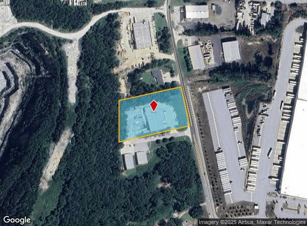
2525 Bright Star Rd, Douglasville, GA 30134
NEARBY LISTINGS FOR SALE OR LEASE
Property Detail
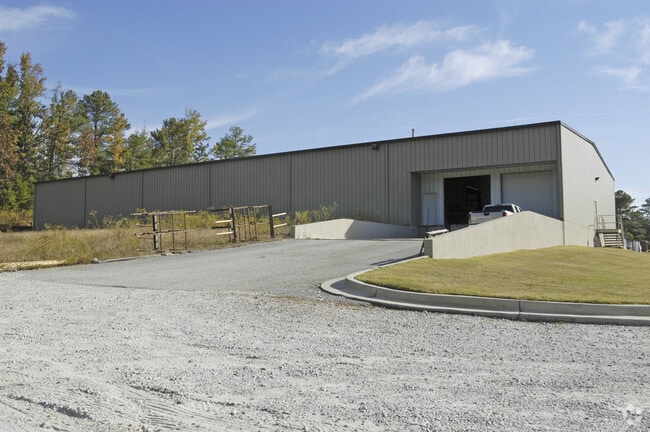
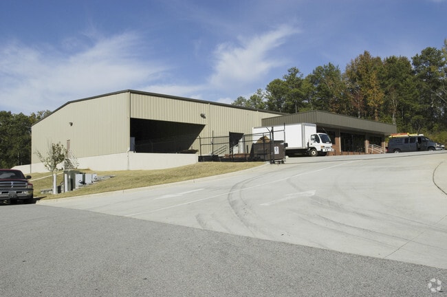
2525 Bright Star Rd
Atlanta-Sandy Springs-Roswell, GA
Couey Morgan Properties
3025-01-6-0-019
BLDG/2.62 ACRES, BRIGHT STAR RD
Warehouse
Douglas
X
Georgia
13097C0132E
163
2024
2.62 AC
2024
I-20 W/Douglasville
080403
Atlanta
15,700 SF
DEMOGRAPHICS near 2525 Bright Star Rd
1 Mile
3 Mile
5 Mile
2024 Total Population
1,821
31,978
80,902
2029 Population
1,893
33,682
86,102
Pop Growth 2024-2029
+ 3.95%
+ 5.33%
+ 6.43%
Average Age
37
37
38
2024 Total Households
791
11,713
28,058
HH Growth 2024-2029
+ 3.92%
+ 5.37%
+ 6.43%
Median Household Inc
$44,894
$54,167
$66,562
Avg Household Size
2.30
2.60
2.80
2024 Avg HH Vehicles
1.00
2.00
2.00
Median Home Value
$177,585
$171,291
$198,345
Median Year Built
1999
1988
1992
Nearby Places
- Restaurants
- Banks
- Shops
- Fitness
- Groceries
PUBLIC TRANSPORTATION
AIRPORT
Hartsfield - Jackson Atlanta International
DRIVE
WALK
Distance
Hartsfield - Jackson Atlanta International
44 min
32.9 mi
Freight Ports
Georgia Ports - Savannah
DRIVE
WALK
Distance
Georgia Ports - Savannah
307 min
272.2 mi
Nearby Properties
Address
Land Use
TOTAL SIZE
Lot Size
Zoning
Address
Land Use
TOTAL SIZE
Lot Size
Zoning
320,483 SF
24.27 AC
DCD
Address
Land Use
TOTAL SIZE
Lot Size
Zoning
299,120 SF
21.37 AC
DCD
Address
Land Use
TOTAL SIZE
Lot Size
Zoning
522,936 SF
39.33 AC
IL
Address
Land Use
TOTAL SIZE
Lot Size
Zoning
500,688 SF
41.29 AC
C-G
Address
Land Use
TOTAL SIZE
Lot Size
Zoning
247,203 SF
18.74 AC
DCD
Address
Land Use
TOTAL SIZE
Lot Size
Zoning
331,774 SF
37.68 AC
DCD
Address
Land Use
TOTAL SIZE
Lot Size
Zoning
263,326 SF
24.07 AC
CG
Address
Land Use
TOTAL SIZE
Lot Size
Zoning
136,748 SF
19 AC
R-6
Address
Land Use
TOTAL SIZE
Lot Size
Zoning
449,595 SF
10.93 AC
R-2
Address
Land Use
TOTAL SIZE
Lot Size
Zoning
166,816 SF
26.23 AC
R-MF
Address
Land Use
TOTAL SIZE
Lot Size
Zoning
132,754 SF
20.35 AC
R-6
Address
Land Use
TOTAL SIZE
Lot Size
Zoning
338,918 SF
24.51 AC
CG
Address
Land Use
TOTAL SIZE
Lot Size
Zoning
200,233 SF
17.49 AC
R-6
Address
Land Use
TOTAL SIZE
Lot Size
Zoning
224,137 SF
22.83 AC
CG
Address
Land Use
TOTAL SIZE
Lot Size
Zoning
100,462 SF
10.21 AC
CG
Address
Land Use
TOTAL SIZE
Lot Size
Zoning
151,822 SF
21.57 AC
CG
Address
Land Use
TOTAL SIZE
Lot Size
Zoning
87,669 SF
9.44 AC
CG
Address
Land Use
TOTAL SIZE
Lot Size
Zoning
72,268 SF
7.26 AC
Address
Land Use
TOTAL SIZE
Lot Size
Zoning
26,274 SF
2.42 AC
OI-L
Address
Land Use
TOTAL SIZE
Lot Size
Zoning
45,088 SF
3.23 AC
OI-L
Address
Land Use
TOTAL SIZE
Lot Size
Zoning
114,267 SF
11.43 AC
CG
Address
Land Use
TOTAL SIZE
Lot Size
Zoning
78,688 SF
12.17 AC
CG
Address
Land Use
TOTAL SIZE
Lot Size
Zoning
110,489 SF
10.71 AC
R-6
Address
Land Use
TOTAL SIZE
Lot Size
Zoning
134,175 SF
15.99 AC
001
Address
Land Use
TOTAL SIZE
Lot Size
Zoning
135,300 SF
16.13 AC
CG
Address
Land Use
TOTAL SIZE
Lot Size
Zoning
58,854 SF
3.07 AC
OI-L
Address
Land Use
TOTAL SIZE
Lot Size
Zoning
87,472 SF
9.10 AC
DCD
Address
Land Use
TOTAL SIZE
Lot Size
Zoning
55,232 SF
4.28 AC
DCD
Address
Land Use
TOTAL SIZE
Lot Size
Zoning
49,148 SF
3.38 AC
CG
Address
Land Use
TOTAL SIZE
Lot Size
Zoning
89,748 SF
2.56 AC
CG
The World's #1 Commercial Real Estate Marketplace
Connect with us
© 2025 CoStar Group
The information above has been obtained from sources believed reliable. While we do not doubt its accuracy we have not verified it and make no guarantee, warranty or representation about it. It is your responsibility to independently confirm its accuracy and completeness. Any projections, opinions, assumptions, or estimates used are for example only and do not represent the current or future performance of the property. The value of this transaction to you depends on tax and other factors which should be evaluated by your tax, financial, and legal advisors. You and your advisors should conduct a careful, independent investigation of the property to determine to your satisfaction the suitability of the property for your needs.