Property Record
2525 Maikalani St, Hilo, HI 96720

This Property Is For Sale
NEARBY LISTINGS FOR SALE OR LEASE
Property Detail
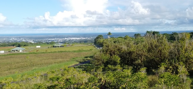
2525 Maikalani St
Hilo, HI
Puueo Farm Lots
3-2-6-029-038-0000
LOT 62 23.50 AC DES PUUEO FARM LOTS TOG/PERP NON-EXCL ESMT FOR ROAD & UTILITY PURP TOG/PERP NON-EXCL ESMT FOR ROAD PURP SUBJ/ESMTS
Agriculturalland
Hawaii
X
Hawaii
1551660885F
62
2024
23.50 AC
2025
Hilo/East Big Island
020500
Hawaii
1,923 SF
DEMOGRAPHICS near 2525 Maikalani St
1 Mile
3 Mile
5 Mile
2024 Total Population
16
16,750
44,575
2029 Population
17
18,126
47,964
Pop Growth 2024-2029
+ 6.25%
+ 8.21%
+ 7.60%
Average Age
40
44
43
2024 Total Households
4
6,296
16,487
HH Growth 2024-2029
0.00%
+ 8.29%
+ 7.53%
Median Household Inc
$39,999
$68,203
$70,809
Avg Household Size
2.60
2.50
2.50
2024 Avg HH Vehicles
2.00
2.00
2.00
Median Home Value
$750,000
$527,743
$474,408
Median Year Built
1994
1979
1979
Nearby Places
Map Layers
Map Styles
 Street
 Aerial
- Restaurants
- Banks
- Shops
- Fitness
- Groceries
PUBLIC TRANSPORTATION
AIRPORT
Hilo International
DRIVE
WALK
Distance
Hilo International
34 min
8.2 mi
Nearby Properties
Address
Land Use
TOTAL SIZE
Lot Size
Zoning
Address
Land Use
TOTAL SIZE
Lot Size
Zoning
231,016 SF
20.40 AC
RS-10
Address
Land Use
TOTAL SIZE
Lot Size
Zoning
5.39 AC
RM-3
Address
Land Use
TOTAL SIZE
Lot Size
Zoning
38,412 SF
6.38 AC
RM-4
Address
Land Use
TOTAL SIZE
Lot Size
Zoning
51,762 SF
9.17 AC
RS-10
Address
Land Use
TOTAL SIZE
Lot Size
Zoning
53,881 SF
1.82 AC
CDH
Address
Land Use
TOTAL SIZE
Lot Size
Zoning
35,854 SF
1.85 AC
V-.75
Address
Land Use
TOTAL SIZE
Lot Size
Zoning
1,837.33 AC
OPEN
Address
Land Use
TOTAL SIZE
Lot Size
Zoning
11,809 SF
10.94 AC
MG-5a
Address
Land Use
TOTAL SIZE
Lot Size
Zoning
26,708 SF
2.05 AC
RS-10
Address
Land Use
TOTAL SIZE
Lot Size
Zoning
17,462 SF
0.76 AC
RS-10
Address
Land Use
TOTAL SIZE
Lot Size
Zoning
1.37 AC
CDH
Address
Land Use
TOTAL SIZE
Lot Size
Zoning
16,905 SF
4.43 AC
A-3a
Address
Land Use
TOTAL SIZE
Lot Size
Zoning
29,471 SF
1.42 AC
RM-3
Address
Land Use
TOTAL SIZE
Lot Size
Zoning
24,557 SF
0.72 AC
RM-1
Address
Land Use
TOTAL SIZE
Lot Size
Zoning
25,732 SF
1.74 AC
CDH
Address
Land Use
TOTAL SIZE
Lot Size
Zoning
24,888 SF
0.69 AC
CDH
Address
Land Use
TOTAL SIZE
Lot Size
Zoning
39,114 SF
1.72 AC
CDH
Address
Land Use
TOTAL SIZE
Lot Size
Zoning
9,971 SF
1.59 AC
RM-3
Address
Land Use
TOTAL SIZE
Lot Size
Zoning
6,860 SF
0.73 AC
CN-10
Address
Land Use
TOTAL SIZE
Lot Size
Zoning
22,662 SF
2.68 AC
CDH
Address
Land Use
TOTAL SIZE
Lot Size
Zoning
18,264 SF
10.88 AC
A-10a
Address
Land Use
TOTAL SIZE
Lot Size
Zoning
26,405 SF
0.25 AC
CDH
Address
Land Use
TOTAL SIZE
Lot Size
Zoning
27,000 SF
1.02 AC
CDH
Address
Land Use
TOTAL SIZE
Lot Size
Zoning
38,705 SF
0.31 AC
CDH
Address
Land Use
TOTAL SIZE
Lot Size
Zoning
16,146 SF
0.96 AC
CG-7.5
Address
Land Use
TOTAL SIZE
Lot Size
Zoning
28,056 SF
0.17 AC
CDH
Address
Land Use
TOTAL SIZE
Lot Size
Zoning
9,268 SF
0.43 AC
CDH
Address
Land Use
TOTAL SIZE
Lot Size
Zoning
20,736 SF
1.25 AC
CG-7.5
Address
Land Use
TOTAL SIZE
Lot Size
Zoning
17,280 SF
0.34 AC
CDH
Address
Land Use
TOTAL SIZE
Lot Size
Zoning
12,464 SF
0.65 AC
CDH
The World's #1 Commercial Real Estate Marketplace
Connect with us
© 2026 CoStar Group
The information above has been obtained from sources believed reliable. While we do not doubt its accuracy we have not verified it and make no guarantee, warranty or representation about it. It is your responsibility to independently confirm its accuracy and completeness. Any projections, opinions, assumptions, or estimates used are for example only and do not represent the current or future performance of the property. The value of this transaction to you depends on tax and other factors which should be evaluated by your tax, financial, and legal advisors. You and your advisors should conduct a careful, independent investigation of the property to determine to your satisfaction the suitability of the property for your needs.