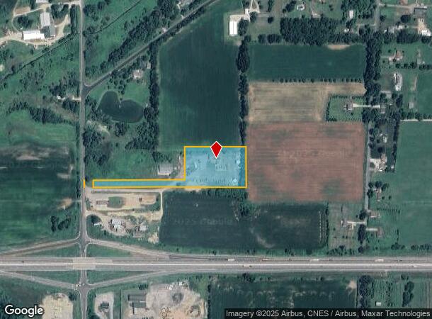
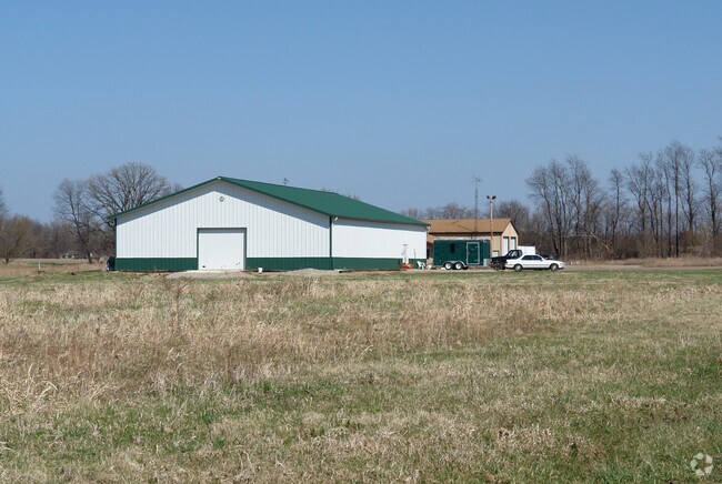
Property Record
2525 N Parma Rd, Parma, MI 49269

NEARBY LISTINGS FOR SALE OR LEASE
-
-
View all Parma listings for sale on LoopNet.com
Property Detail
2525 N Parma Rd
000-07-30-176-001-07
BEG AT NW COR OF SEC 30 TH S ALG W SEC LN OF SECTION 30 AND THE CENTERLINE OF PARMA ROAD 2104.47 FEET: THENCE SOUTH 89*29'
Autorepair
Jackson
X
Michigan
26075C0175D
5.10 AC
2024
Jackson County
2025
West Michigan
006500
Jackson, MI
6,752 SF
DEMOGRAPHICS near 2525 N Parma Rd
1 Mile
3 Mile
5 Mile
2024 Total Population
600
2,836
9,605
2029 Population
592
2,794
9,514
Pop Growth 2024-2029
(1.33%)
(1.48%)
(0.95%)
Average Age
40
41
39
2024 Total Households
219
1,053
3,255
HH Growth 2024-2029
(1.37%)
(1.61%)
(1.14%)
Median Household Inc
$75,403
$73,467
$67,094
Avg Household Size
2.70
2.60
2.50
2024 Avg HH Vehicles
2.00
2.00
2.00
Median Home Value
$178,571
$174,649
$173,450
Median Year Built
1972
1973
1975
Nearby Places
Map Layers
Map Styles
 Street
 Aerial
- Restaurants
- Banks
- Shops
- Fitness
- Groceries
PUBLIC TRANSPORTATION
COMMUTER RAIL
Albion (Wolverine - Amtrak)
DRIVE
WALK
Distance
Albion (Wolverine - Amtrak)
13 min
9.4 mi
Freight Ports
Port of Toledo
DRIVE
WALK
Distance
Port of Toledo
117 min
91.6 mi
Nearby Properties
Address
Land Use
TOTAL SIZE
Lot Size
Zoning
Address
Land Use
TOTAL SIZE
Lot Size
Zoning
994,960 SF
93.25 AC
C-2 GEN
Address
Land Use
TOTAL SIZE
Lot Size
Zoning
5,480 SF
9.78 AC
L.I-1
Address
Land Use
TOTAL SIZE
Lot Size
Zoning
27,800 SF
3.27 AC
L.I-1
Address
Land Use
TOTAL SIZE
Lot Size
Zoning
8,680 SF
10.92 AC
C 2
Address
Land Use
TOTAL SIZE
Lot Size
Zoning
138 AC
AG 1
Address
Land Use
TOTAL SIZE
Lot Size
Zoning
7,488 SF
73.30 AC
AG-1
Address
Land Use
TOTAL SIZE
Lot Size
Zoning
119.70 AC
AG 1
Address
Land Use
TOTAL SIZE
Lot Size
Zoning
115.43 AC
AG 1
Address
Land Use
TOTAL SIZE
Lot Size
Zoning
12,078 SF
15.44 AC
C 2
Address
Land Use
TOTAL SIZE
Lot Size
Zoning
113 AC
AG 1
Address
Land Use
TOTAL SIZE
Lot Size
Zoning
5 AC
AG
Address
Land Use
TOTAL SIZE
Lot Size
Zoning
18.90 AC
AG 1
Address
Land Use
TOTAL SIZE
Lot Size
Zoning
3,164 SF
140.22 AC
AG-1
Address
Land Use
TOTAL SIZE
Lot Size
Zoning
85 AC
AG 1
Address
Land Use
TOTAL SIZE
Lot Size
Zoning
158.30 AC
AG 1
Address
Land Use
TOTAL SIZE
Lot Size
Zoning
2,340 SF
140.50 AC
AG-1
Address
Land Use
TOTAL SIZE
Lot Size
Zoning
2,540 SF
173.10 AC
AG 1
Address
Land Use
TOTAL SIZE
Lot Size
Zoning
2,044 SF
157 AC
AG 1
Address
Land Use
TOTAL SIZE
Lot Size
Zoning
21,000 SF
3.18 AC
L.I-1
Address
Land Use
TOTAL SIZE
Lot Size
Zoning
157.50 AC
AG
Address
Land Use
TOTAL SIZE
Lot Size
Zoning
178.11 AC
AG
Address
Land Use
TOTAL SIZE
Lot Size
Zoning
157.91 AC
AG
Address
Land Use
TOTAL SIZE
Lot Size
Zoning
159 AC
AG 1
Address
Land Use
TOTAL SIZE
Lot Size
Zoning
65 AC
AG 1
Address
Land Use
TOTAL SIZE
Lot Size
Zoning
106.19 AC
AG 1
Address
Land Use
TOTAL SIZE
Lot Size
Zoning
1,772 SF
111.76 AC
AG-1
Address
Land Use
TOTAL SIZE
Lot Size
Zoning
65 AC
AG 1
Address
Land Use
TOTAL SIZE
Lot Size
Zoning
153.03 AC
AG-1
Address
Land Use
TOTAL SIZE
Lot Size
Zoning
14,400 SF
6.99 AC
L.I-1
Address
Land Use
TOTAL SIZE
Lot Size
Zoning
60 AC
AG 1
The World's #1 Commercial Real Estate Marketplace
Connect with us
© 2026 CoStar Group
The information above has been obtained from sources believed reliable. While we do not doubt its accuracy we have not verified it and make no guarantee, warranty or representation about it. It is your responsibility to independently confirm its accuracy and completeness. Any projections, opinions, assumptions, or estimates used are for example only and do not represent the current or future performance of the property. The value of this transaction to you depends on tax and other factors which should be evaluated by your tax, financial, and legal advisors. You and your advisors should conduct a careful, independent investigation of the property to determine to your satisfaction the suitability of the property for your needs.