Property Record
2525 Needham Rd, Patterson, CA 95363

Property Detail
2525 Needham Rd
021-13-12
MAP B6 00004
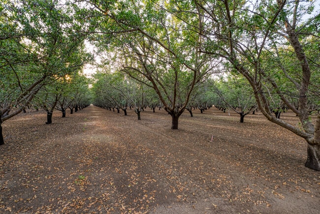
Orchard
STANISLAUS
A240
California
B and X Area of moderate flood hazard, usually the area between the limits of the 100-year and 500-year floods.
23.14 AC
2025
Turlock/SW Stanislaus
2025
Stockton/Modesto
003204
Modesto, CA
3,161 SF
NEARBY LISTINGS FOR SALE OR LEASE
-
-
View all Patterson listings for sale on LoopNet.com
DEMOGRAPHICS near 2525 Needham Rd
1 mile
3 mile
5 mile
2024 Total Population
10
159
7,087
2029 Population
9
153
7,015
Pop Growth 2024-2029
(10.00%)
(3.77%)
(1.02%)
Average Age
32
36
35
2024 Total Households
3
50
1,860
HH Growth 2024-2029
0.00%
(4.00%)
(1.08%)
Median Household Inc
$87,500
$87,500
$92,445
Avg Household Size
2.00
3.20
3.70
2024 Avg HH Vehicles
2.00
3.00
3.00
Median Home Value
$499,999
$480,768
$443,341
Median Year Built
2002
1999
2002
Nearby Places
Map Layers
Map Styles
 Street
 Aerial
Transit
 Traffic
 Biking
Places
Listings with unknown addresses are not visible on the map
- Restaurants
- Banks
- Shops
- Fitness
- Groceries
PUBLIC TRANSPORTATION
AIRPORT
Stockton Metro
Drive
Walk
Distance
Stockton Metro
45 min
34.3 mi
Freight Ports
Port of Stockton
Drive
Walk
Distance
Port of Stockton
48 min
37.6 mi
SALE & LEASE HISTORY
LISTING DATE
SALE/LEASE

Sep 29, 2020
For Sale
Nearby Properties
Address
Land Use
TOTAL SIZE
Lot Size
Zoning
Address
Land Use
TOTAL SIZE
Lot Size
Zoning
20.59 AC
Address
Land Use
TOTAL SIZE
Lot Size
Zoning
30,625 SF
2.10 AC
Address
Land Use
TOTAL SIZE
Lot Size
Zoning
25,625 SF
11.80 AC
PC
Address
Land Use
TOTAL SIZE
Lot Size
Zoning
68.68 AC
PATLI
Address
Land Use
TOTAL SIZE
Lot Size
Zoning
51.90 AC
PATLI
Address
Land Use
TOTAL SIZE
Lot Size
Zoning
2,930 SF
1 AC
Address
Land Use
TOTAL SIZE
Lot Size
Zoning
539.35 AC
Address
Land Use
TOTAL SIZE
Lot Size
Zoning
40.28 AC
PATLI
Address
Land Use
TOTAL SIZE
Lot Size
Zoning
39.67 AC
PATLI
Address
Land Use
TOTAL SIZE
Lot Size
Zoning
39.67 AC
PATLI
Address
Land Use
TOTAL SIZE
Lot Size
Zoning
39.53 AC
PATLI
Address
Land Use
TOTAL SIZE
Lot Size
Zoning
39.29 AC
PATLI
Address
Land Use
TOTAL SIZE
Lot Size
Zoning
38.32 AC
PATLI
Address
Land Use
TOTAL SIZE
Lot Size
Zoning
83.93 AC
Address
Land Use
TOTAL SIZE
Lot Size
Zoning
3,470 SF
58.05 AC
A240
Address
Land Use
TOTAL SIZE
Lot Size
Zoning
1,492 SF
225.08 AC
A240
Address
Land Use
TOTAL SIZE
Lot Size
Zoning
5,020 SF
135 AC
A240
Address
Land Use
TOTAL SIZE
Lot Size
Zoning
3,017 SF
1.94 AC
Address
Land Use
TOTAL SIZE
Lot Size
Zoning
4.76 AC
A240
Address
Land Use
TOTAL SIZE
Lot Size
Zoning
3,309 SF
225.06 AC
A340
Address
Land Use
TOTAL SIZE
Lot Size
Zoning
262.69 AC
A240
Address
Land Use
TOTAL SIZE
Lot Size
Zoning
280,000 SF
52.11 AC
A340
Address
Land Use
TOTAL SIZE
Lot Size
Zoning
175 AC
A240
Address
Land Use
TOTAL SIZE
Lot Size
Zoning
16,996 SF
2.29 AC
Address
Land Use
TOTAL SIZE
Lot Size
Zoning
209.69 AC
Address
Land Use
TOTAL SIZE
Lot Size
Zoning
209,824 SF
14.06 AC
A210
Address
Land Use
TOTAL SIZE
Lot Size
Zoning
66.29 AC
Address
Land Use
TOTAL SIZE
Lot Size
Zoning
66.47 AC
Address
Land Use
TOTAL SIZE
Lot Size
Zoning
Address
Land Use
TOTAL SIZE
Lot Size
Zoning
162.71 AC
The World's #1 Commercial Real Estate Marketplace
Connect with us
© 2026 CoStar Group
The information above has been obtained from sources believed reliable. While we do not doubt its accuracy we have not verified it and make no guarantee, warranty or representation about it. It is your responsibility to independently confirm its accuracy and completeness. Any projections, opinions, assumptions, or estimates used are for example only and do not represent the current or future performance of the property. The value of this transaction to you depends on tax and other factors which should be evaluated by your tax, financial, and legal advisors. You and your advisors should conduct a careful, independent investigation of the property to determine to your satisfaction the suitability of the property for your needs.