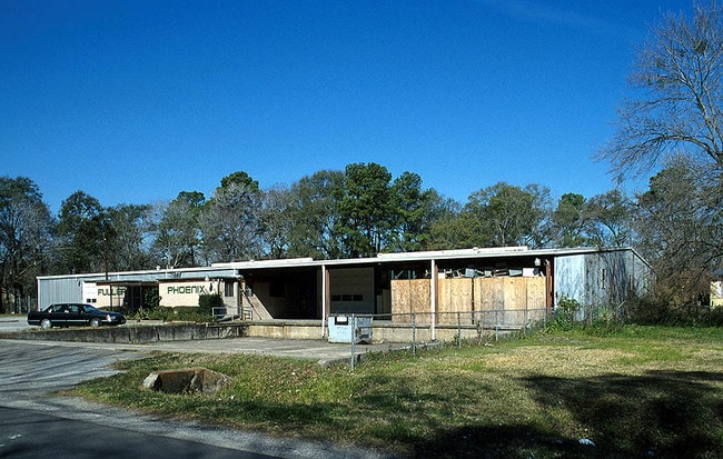
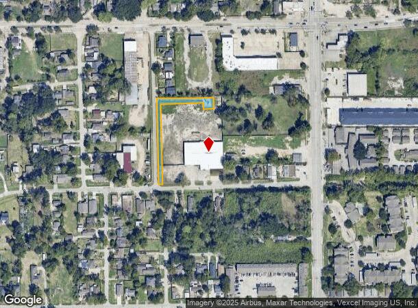
Property Record
2525 Vaughn St, Houston, TX 77093

NEARBY LISTINGS FOR SALE OR LEASE
Property Detail
2525 Vaughn St
0422300000345
Abst 329 J T Harrell
Commercialacreage
TR 29 ABST 329 J T HARRELL
X
Harris
48201C0680L
Texas
2024
0.59 AC
2025
North Outer Loop
220702
Houston
22,636 SF
Houston-The Woodlands-Sugar Land, TX
DEMOGRAPHICS near 2525 Vaughn St
1 Mile
3 Mile
5 Mile
2024 Total Population
14,055
120,397
352,751
2029 Population
14,417
123,897
364,308
Pop Growth 2024-2029
+ 2.58%
+ 2.91%
+ 3.28%
Average Age
35
37
37
2024 Total Households
4,478
40,953
126,030
HH Growth 2024-2029
+ 2.52%
+ 2.96%
+ 3.68%
Median Household Inc
$32,317
$37,291
$49,069
Avg Household Size
3.10
2.90
2.60
2024 Avg HH Vehicles
2.00
2.00
2.00
Median Home Value
$120,798
$161,782
$206,153
Median Year Built
1963
1960
1967
Nearby Places
Map Layers
Map Styles
 Street
 Aerial
- Restaurants
- Banks
- Shops
- Fitness
- Groceries
PUBLIC TRANSPORTATION
COMMUTER RAIL
Houston (Sunset Limited - Amtrak)
DRIVE
WALK
Distance
Houston (Sunset Limited - Amtrak)
12 min
6.9 mi
AIRPORT
George Bush Intcntl/Houston
DRIVE
WALK
Distance
George Bush Intcntl/Houston
19 min
15.0 mi
William P Hobby
DRIVE
WALK
Distance
William P Hobby
30 min
17.9 mi
Freight Ports
Port of Houston
DRIVE
WALK
Distance
Port of Houston
19 min
11.3 mi
SALE & LEASE HISTORY
LISTING DATE
SALE/LEASE

May 25, 2023
For Sale
Feb 06, 2023
For Lease
Nearby Properties
Address
Land Use
TOTAL SIZE
Lot Size
Zoning
Address
Land Use
TOTAL SIZE
Lot Size
Zoning
474,326 SF
43.16 AC
Address
Land Use
TOTAL SIZE
Lot Size
Zoning
587,156 SF
4.40 AC
Address
Land Use
TOTAL SIZE
Lot Size
Zoning
263,475 SF
7.90 AC
Address
Land Use
TOTAL SIZE
Lot Size
Zoning
276,332 SF
6.05 AC
Address
Land Use
TOTAL SIZE
Lot Size
Zoning
545,628 SF
19.41 AC
Address
Land Use
TOTAL SIZE
Lot Size
Zoning
213,548 SF
16.98 AC
Address
Land Use
TOTAL SIZE
Lot Size
Zoning
188,582 SF
17.94 AC
Address
Land Use
TOTAL SIZE
Lot Size
Zoning
304,925 SF
10.91 AC
Address
Land Use
TOTAL SIZE
Lot Size
Zoning
66,588 SF
3.95 AC
Address
Land Use
TOTAL SIZE
Lot Size
Zoning
177,720 SF
14.96 AC
Address
Land Use
TOTAL SIZE
Lot Size
Zoning
234,016 SF
7.75 AC
Address
Land Use
TOTAL SIZE
Lot Size
Zoning
55,517 SF
13 AC
Address
Land Use
TOTAL SIZE
Lot Size
Zoning
113,014 SF
3.50 AC
Address
Land Use
TOTAL SIZE
Lot Size
Zoning
241,435 SF
13.47 AC
Address
Land Use
TOTAL SIZE
Lot Size
Zoning
15,917 SF
15.07 AC
Address
Land Use
TOTAL SIZE
Lot Size
Zoning
82,951 SF
21.32 AC
Address
Land Use
TOTAL SIZE
Lot Size
Zoning
51,941 SF
3.71 AC
Address
Land Use
TOTAL SIZE
Lot Size
Zoning
102,214 SF
11.26 AC
Address
Land Use
TOTAL SIZE
Lot Size
Zoning
186,629 SF
9.75 AC
Address
Land Use
TOTAL SIZE
Lot Size
Zoning
264,312 SF
9.78 AC
Address
Land Use
TOTAL SIZE
Lot Size
Zoning
622,385 SF
6.68 AC
Address
Land Use
TOTAL SIZE
Lot Size
Zoning
197,976 SF
24.32 AC
Address
Land Use
TOTAL SIZE
Lot Size
Zoning
67,380 SF
1.81 AC
Address
Land Use
TOTAL SIZE
Lot Size
Zoning
40,966 SF
3.30 AC
Address
Land Use
TOTAL SIZE
Lot Size
Zoning
136,996 SF
29.18 AC
Address
Land Use
TOTAL SIZE
Lot Size
Zoning
48,058 SF
4.42 AC
Address
Land Use
TOTAL SIZE
Lot Size
Zoning
60,577 SF
2.10 AC
Address
Land Use
TOTAL SIZE
Lot Size
Zoning
63,362 SF
2.37 AC
Address
Land Use
TOTAL SIZE
Lot Size
Zoning
129,204 SF
7.03 AC
Address
Land Use
TOTAL SIZE
Lot Size
Zoning
122,305 SF
16.08 AC
The World's #1 Commercial Real Estate Marketplace
Connect with us
© 2025 CoStar Group
The information above has been obtained from sources believed reliable. While we do not doubt its accuracy we have not verified it and make no guarantee, warranty or representation about it. It is your responsibility to independently confirm its accuracy and completeness. Any projections, opinions, assumptions, or estimates used are for example only and do not represent the current or future performance of the property. The value of this transaction to you depends on tax and other factors which should be evaluated by your tax, financial, and legal advisors. You and your advisors should conduct a careful, independent investigation of the property to determine to your satisfaction the suitability of the property for your needs.