Property Record
2515 W Liberty Rd, Westminster, MD 21157

Save to a Folder
{{folder.Name}}
{{folder.ListingIds.length}} Properties
{{folder.ListingIds.length}} Property
Create a New Folder
This Property Is For Sale
Property Detail
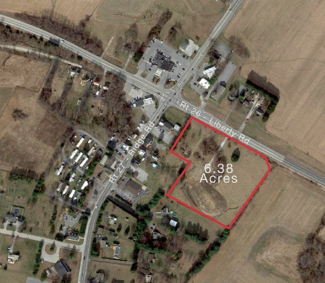
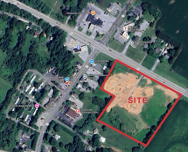
2515 W Liberty Rd
Baltimore-Columbia-Towson, MD
LT 10C - 6.38 ACS 2515 LIBERTY RD 52-12 AM OXFORD MEWS
09-023968
Carroll
Commercialacreage
Maryland
C-2
10c
B and X Area of moderate flood hazard, usually the area between the limits of the 100-year and 500-year floods.
6.38 AC
2025
Carroll County
2025
Baltimore
509001
NEARBY LISTINGS FOR SALE OR LEASE
DEMOGRAPHICS near 2515 W Liberty Rd
1 mile
3 mile
5 mile
2025 Total Population
1,173
7,907
18,210
2030 Population
1,188
8,050
18,614
Pop Growth 2025-2030
+ 1.28%
+ 1.81%
+ 2.22%
Average Age
44
44
43
2025 Total Households
425
2,825
6,382
HH Growth 2025-2030
+ 1.41%
+ 1.88%
+ 2.23%
Median Household Inc
$141,562
$128,489
$141,209
Avg Household Size
2.70
2.70
2.80
2025 Avg HH Vehicles
3.00
3.00
3.00
Median Home Value
$527,363
$498,702
$570,988
Median Year Built
1982
1981
1982
Nearby Places
Map Layers
Map Styles
 Street
 Aerial
Layers
 Traffic
 Biking
Places
Listings with unknown addresses are not visible on the map
- Restaurants
- Banks
- Shops
- Fitness
- Groceries
PUBLIC TRANSPORTATION
AIRPORT
Baltimore/Washington International Thurgood Marshall
Drive
Walk
Distance
Baltimore/Washington International Thurgood Marshall
54 min
43.4 mi
Freight Ports
Port of Baltimore
Drive
Walk
Distance
Port of Baltimore
55 min
43.9 mi
Nearby Properties
Address
Land Use
TOTAL SIZE
Lot Size
Zoning
Address
Land Use
TOTAL SIZE
Lot Size
Zoning
109,470 SF
144.52 AC
CONSE
Address
Land Use
TOTAL SIZE
Lot Size
Zoning
81,498 SF
5.99 AC
AGRIC
Address
Land Use
TOTAL SIZE
Lot Size
Zoning
13,806 SF
6 AC
AGRIC
Address
Land Use
TOTAL SIZE
Lot Size
Zoning
8,884 SF
44.53 AC
AGRIC
Address
Land Use
TOTAL SIZE
Lot Size
Zoning
780 SF
1.93 AC
C-2
Address
Land Use
TOTAL SIZE
Lot Size
Zoning
3,580 SF
10.07 AC
AGRIC
Address
Land Use
TOTAL SIZE
Lot Size
Zoning
12,940 SF
4.47 AC
R-400
Address
Land Use
TOTAL SIZE
Lot Size
Zoning
1,360 SF
30.46 AC
AGRIC
Address
Land Use
TOTAL SIZE
Lot Size
Zoning
9,663 SF
3.03 AC
R-400
Address
Land Use
TOTAL SIZE
Lot Size
Zoning
8,640 SF
6.02 AC
C-2
Address
Land Use
TOTAL SIZE
Lot Size
Zoning
1,440 SF
5.13 AC
C-2
Address
Land Use
TOTAL SIZE
Lot Size
Zoning
17,032 SF
5.10 AC
AGRIC
Address
Land Use
TOTAL SIZE
Lot Size
Zoning
1,416 SF
4.78 AC
C-2
Address
Land Use
TOTAL SIZE
Lot Size
Zoning
1,215 SF
1.17 AC
C-2
Address
Land Use
TOTAL SIZE
Lot Size
Zoning
6,496 SF
3.16 AC
AGRIC
Address
Land Use
TOTAL SIZE
Lot Size
Zoning
4,700 SF
6.17 AC
AGRIC
Address
Land Use
TOTAL SIZE
Lot Size
Zoning
7,308 SF
2.71 AC
R-400
Address
Land Use
TOTAL SIZE
Lot Size
Zoning
1,376 SF
50.25 AC
AGRIC
Address
Land Use
TOTAL SIZE
Lot Size
Zoning
1,260 SF
0.74 AC
C-2
Address
Land Use
TOTAL SIZE
Lot Size
Zoning
4,324 SF
3.91 AC
C-2
Address
Land Use
TOTAL SIZE
Lot Size
Zoning
7,933 SF
1.78 AC
AGRIC
Address
Land Use
TOTAL SIZE
Lot Size
Zoning
1,664 SF
6.79 AC
AGRIC
Address
Land Use
TOTAL SIZE
Lot Size
Zoning
5,166 SF
1.28 AC
C-1
Address
Land Use
TOTAL SIZE
Lot Size
Zoning
5,632 SF
3.04 AC
AGRIC
Address
Land Use
TOTAL SIZE
Lot Size
Zoning
3,696 SF
7.72 AC
AGRIC
Address
Land Use
TOTAL SIZE
Lot Size
Zoning
5,374 SF
25.07 AC
A
Address
Land Use
TOTAL SIZE
Lot Size
Zoning
2,241 SF
1.54 AC
C-2
Address
Land Use
TOTAL SIZE
Lot Size
Zoning
3,460 SF
0.98 AC
R-400
Address
Land Use
TOTAL SIZE
Lot Size
Zoning
4,481 SF
4 AC
A
The World's #1 Commercial Real Estate Marketplace
Connect with us
© 2026 CoStar Group
The information above has been obtained from sources believed reliable. While we do not doubt its accuracy we have not verified it and make no guarantee, warranty or representation about it. It is your responsibility to independently confirm its accuracy and completeness. Any projections, opinions, assumptions, or estimates used are for example only and do not represent the current or future performance of the property. The value of this transaction to you depends on tax and other factors which should be evaluated by your tax, financial, and legal advisors. You and your advisors should conduct a careful, independent investigation of the property to determine to your satisfaction the suitability of the property for your needs.