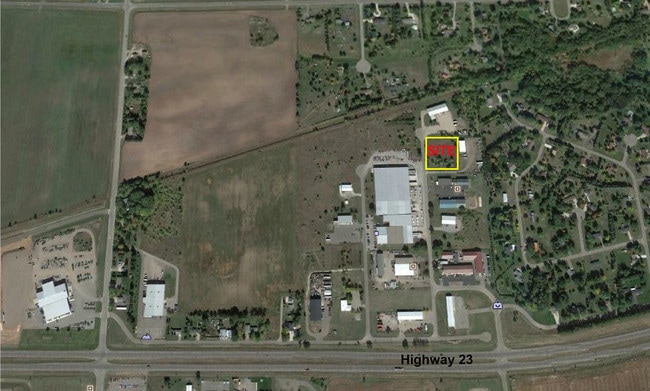
Property Record
25252 County Road 74, Saint Cloud, MN 56301
NEARBY LISTINGS FOR SALE OR LEASE
Property Detail
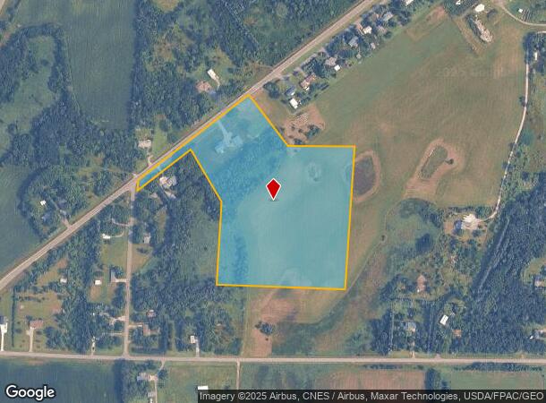
25252 County Road 74
82.43630.0000
19.53 A. PT OF W2SW4 DAF COMM AT SW COR - N 488.13' - E 521.64' TO POB - N 567.57' - N38D W 327.92' TO ROW - SW'LY ON ROW
Realpropertynec
Stearns
X
Minnesota
27145C0855E
19.53 AC
2025
Stearns County
2025
Minneapolis/St Paul
000402
St. Cloud, MN
DEMOGRAPHICS near 25252 County Road 74
1 Mile
3 Mile
5 Mile
2024 Total Population
171
4,478
31,292
2029 Population
179
4,739
32,612
Pop Growth 2024-2029
+ 4.68%
+ 5.83%
+ 4.22%
Average Age
41
40
38
2024 Total Households
65
1,687
12,550
HH Growth 2024-2029
+ 4.62%
+ 6.05%
+ 4.31%
Median Household Inc
$69,166
$79,753
$64,046
Avg Household Size
2.50
2.60
2.40
2024 Avg HH Vehicles
2.00
2.00
2.00
Median Home Value
$216,667
$299,051
$255,043
Median Year Built
1982
1993
1992
Nearby Places
Map Layers
Map Styles
 Street
 Aerial
- Restaurants
- Banks
- Shops
- Fitness
- Groceries
PUBLIC TRANSPORTATION
COMMUTER RAIL
St. Cloud Amtrak Station (Empire Builder - Amtrak)
DRIVE
WALK
Distance
St. Cloud Amtrak Station (Empire Builder - Amtrak)
15 min
9.6 mi
Freight Ports
Port Milwaukee
DRIVE
WALK
Distance
Port Milwaukee
447 min
404.9 mi
SALE & LEASE HISTORY
LISTING DATE
SALE/LEASE

Mar 31, 2017
For Sale
Nearby Properties
Address
Land Use
TOTAL SIZE
Lot Size
Zoning
Address
Land Use
TOTAL SIZE
Lot Size
Zoning
307,404 SF
105.31 AC
Address
Land Use
TOTAL SIZE
Lot Size
Zoning
19.83 AC
Address
Land Use
TOTAL SIZE
Lot Size
Zoning
Address
Land Use
TOTAL SIZE
Lot Size
Zoning
85,428 SF
12.73 AC
AG
Address
Land Use
TOTAL SIZE
Lot Size
Zoning
12.57 AC
Address
Land Use
TOTAL SIZE
Lot Size
Zoning
1,675 SF
77.18 AC
2B
Address
Land Use
TOTAL SIZE
Lot Size
Zoning
5.02 AC
Address
Land Use
TOTAL SIZE
Lot Size
Zoning
13,526 SF
18.60 AC
Address
Land Use
TOTAL SIZE
Lot Size
Zoning
1,662 SF
14 AC
Address
Land Use
TOTAL SIZE
Lot Size
Zoning
40,226 SF
6.76 AC
Address
Land Use
TOTAL SIZE
Lot Size
Zoning
8,000 SF
72.09 AC
Address
Land Use
TOTAL SIZE
Lot Size
Zoning
3.22 AC
Address
Land Use
TOTAL SIZE
Lot Size
Zoning
1,012 SF
10 AC
Address
Land Use
TOTAL SIZE
Lot Size
Zoning
4,050 SF
39.50 AC
RPMKT
Address
Land Use
TOTAL SIZE
Lot Size
Zoning
2.81 AC
PUD78
Address
Land Use
TOTAL SIZE
Lot Size
Zoning
Address
Land Use
TOTAL SIZE
Lot Size
Zoning
960 SF
2.24 AC
Address
Land Use
TOTAL SIZE
Lot Size
Zoning
8,296 SF
64.60 AC
2B
Address
Land Use
TOTAL SIZE
Lot Size
Zoning
9,660 SF
1 AC
Address
Land Use
TOTAL SIZE
Lot Size
Zoning
13,894 SF
2.58 AC
Address
Land Use
TOTAL SIZE
Lot Size
Zoning
0.99 AC
Address
Land Use
TOTAL SIZE
Lot Size
Zoning
17,052 SF
19.31 AC
C5
Address
Land Use
TOTAL SIZE
Lot Size
Zoning
696 SF
80 AC
RPMKT
Address
Land Use
TOTAL SIZE
Lot Size
Zoning
1,249 SF
150 AC
2A
Address
Land Use
TOTAL SIZE
Lot Size
Zoning
163.98 AC
Address
Land Use
TOTAL SIZE
Lot Size
Zoning
143.13 AC
Address
Land Use
TOTAL SIZE
Lot Size
Zoning
238 SF
97.55 AC
Address
Land Use
TOTAL SIZE
Lot Size
Zoning
3.99 AC
The World's #1 Commercial Real Estate Marketplace
Connect with us
© 2026 CoStar Group
The information above has been obtained from sources believed reliable. While we do not doubt its accuracy we have not verified it and make no guarantee, warranty or representation about it. It is your responsibility to independently confirm its accuracy and completeness. Any projections, opinions, assumptions, or estimates used are for example only and do not represent the current or future performance of the property. The value of this transaction to you depends on tax and other factors which should be evaluated by your tax, financial, and legal advisors. You and your advisors should conduct a careful, independent investigation of the property to determine to your satisfaction the suitability of the property for your needs.