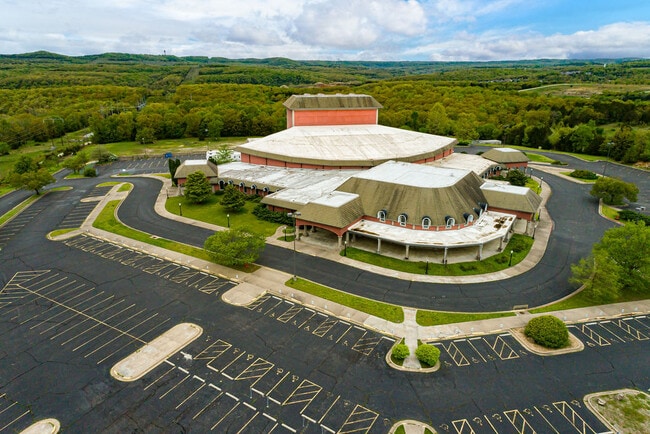
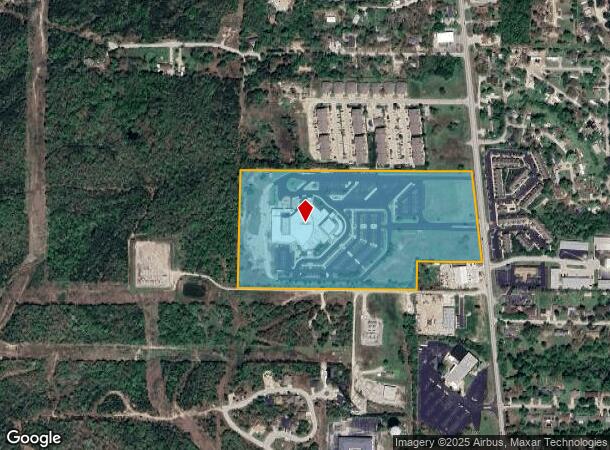
Property Record
2527 State Highway 248, Branson, MO 65616
NEARBY LISTINGS FOR SALE OR LEASE
-
-
View all Branson listings for sale on LoopNet.com
Property Detail
2527 State Highway 248
08-4.0-19-003-007-012.000
PT S2 LTS 1 & 2 SW4 W OF MSH 248
Agriculturalland
Taney
X
Missouri
29209C0225D
1,2
2024
23.86 AC
2025
Branson
480206
Other Market Areas
1,804,046 SF
Branson, MO
DEMOGRAPHICS near 2527 State Highway 248
1 mile
3 mile
5 mile
2024 Total Population
2,196
13,242
34,099
2029 Population
2,197
13,620
35,234
Pop Growth 2024-2029
+ 0.05%
+ 2.85%
+ 3.33%
Average Age
39
42
41
2024 Total Households
847
5,709
13,688
HH Growth 2024-2029
(0.47%)
+ 2.91%
+ 3.41%
Median Household Inc
$58,999
$52,726
$53,319
Avg Household Size
2.50
2.20
2.30
2024 Avg HH Vehicles
2.00
2.00
2.00
Median Home Value
$240,322
$194,811
$185,355
Median Year Built
1991
1997
1996
Nearby Places
Map Layers
Map Styles
 Street
 Aerial
Transit
 Traffic
 Biking
Places
Listings with unknown addresses are not visible on the map
- Restaurants
- Banks
- Shops
- Fitness
- Groceries
SALE & LEASE HISTORY
LISTING DATE
SALE/LEASE

May 20, 2022
For Sale
Nearby Properties
Address
Land Use
TOTAL SIZE
Lot Size
Zoning
Address
Land Use
TOTAL SIZE
Lot Size
Zoning
50,417 SF
17.43 AC
Address
Land Use
TOTAL SIZE
Lot Size
Zoning
350,270 SF
40 AC
Address
Land Use
TOTAL SIZE
Lot Size
Zoning
66,272 SF
7.83 AC
Address
Land Use
TOTAL SIZE
Lot Size
Zoning
140,093 SF
8.37 AC
Address
Land Use
TOTAL SIZE
Lot Size
Zoning
59,939 SF
15.76 AC
Address
Land Use
TOTAL SIZE
Lot Size
Zoning
26,658 SF
6.30 AC
Address
Land Use
TOTAL SIZE
Lot Size
Zoning
43,276 SF
5.93 AC
Address
Land Use
TOTAL SIZE
Lot Size
Zoning
18,781 SF
4.70 AC
Address
Land Use
TOTAL SIZE
Lot Size
Zoning
123,377 SF
13.05 AC
Address
Land Use
TOTAL SIZE
Lot Size
Zoning
125,330 SF
15 AC
Address
Land Use
TOTAL SIZE
Lot Size
Zoning
63,890 SF
14.45 AC
Address
Land Use
TOTAL SIZE
Lot Size
Zoning
27,496 SF
3.34 AC
Address
Land Use
TOTAL SIZE
Lot Size
Zoning
104,868 SF
13.61 AC
Address
Land Use
TOTAL SIZE
Lot Size
Zoning
12,542 SF
3.87 AC
Address
Land Use
TOTAL SIZE
Lot Size
Zoning
19,872 SF
2.97 AC
Address
Land Use
TOTAL SIZE
Lot Size
Zoning
17,037 SF
5.35 AC
Address
Land Use
TOTAL SIZE
Lot Size
Zoning
45,680 SF
11.85 AC
Address
Land Use
TOTAL SIZE
Lot Size
Zoning
25,760 SF
6.47 AC
Address
Land Use
TOTAL SIZE
Lot Size
Zoning
55,651 SF
3.95 AC
Address
Land Use
TOTAL SIZE
Lot Size
Zoning
24,176 SF
10.28 AC
Address
Land Use
TOTAL SIZE
Lot Size
Zoning
51,392 SF
6.66 AC
Address
Land Use
TOTAL SIZE
Lot Size
Zoning
53,728 SF
6.74 AC
Address
Land Use
TOTAL SIZE
Lot Size
Zoning
17,313 SF
5.18 AC
Address
Land Use
TOTAL SIZE
Lot Size
Zoning
48,182 SF
15 AC
Address
Land Use
TOTAL SIZE
Lot Size
Zoning
51,842 SF
3.48 AC
Address
Land Use
TOTAL SIZE
Lot Size
Zoning
44,871 SF
4.57 AC
Address
Land Use
TOTAL SIZE
Lot Size
Zoning
18,308 SF
2.59 AC
Address
Land Use
TOTAL SIZE
Lot Size
Zoning
34,856 SF
15.68 AC
The World's #1 Commercial Real Estate Marketplace
Connect with us
© 2026 CoStar Group
The information above has been obtained from sources believed reliable. While we do not doubt its accuracy we have not verified it and make no guarantee, warranty or representation about it. It is your responsibility to independently confirm its accuracy and completeness. Any projections, opinions, assumptions, or estimates used are for example only and do not represent the current or future performance of the property. The value of this transaction to you depends on tax and other factors which should be evaluated by your tax, financial, and legal advisors. You and your advisors should conduct a careful, independent investigation of the property to determine to your satisfaction the suitability of the property for your needs.