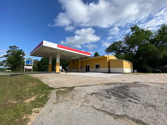
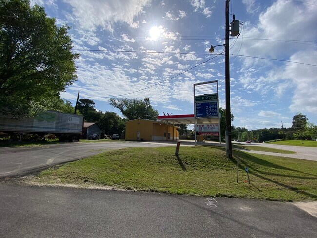
Property Record
25289 Fm 2090 Rd, Splendora, TX 77372

Property Detail
25289 Fm 2090 Rd
0082-01-05100
A0082 - BARKER WM, TRACT 8-C, 51, ACRES 0.472
Commercialnec
Montgomery
5
Texas
B and X Area of moderate flood hazard, usually the area between the limits of the 100-year and 500-year floods.
0.47 AC
2024
Montgomery County
2025
Houston
692900
Houston-Pasadena-The Woodlands, TX
2,142 SF
NEARBY LISTINGS FOR SALE OR LEASE
DEMOGRAPHICS near 25289 Fm 2090 Rd
1 mile
3 mile
5 mile
2025 Total Population
1,655
12,686
37,186
2030 Population
1,964
15,041
44,479
Pop Growth 2025-2030
+ 18.67%
+ 18.56%
+ 19.61%
Average Age
37
37
37
2025 Total Households
548
4,213
12,348
HH Growth 2025-2030
+ 19.16%
+ 19.15%
+ 20.13%
Median Household Inc
$91,666
$78,642
$82,136
Avg Household Size
2.90
3.00
3.00
2025 Avg HH Vehicles
2.00
2.00
2.00
Median Home Value
$265,999
$280,651
$284,063
Median Year Built
2000
2001
2004
Nearby Places
Map Layers
Map Styles
 Street
 Aerial
Transit
 Traffic
 Biking
Places
Listings with unknown addresses are not visible on the map
- Restaurants
- Banks
- Shops
- Fitness
- Groceries
PUBLIC TRANSPORTATION
AIRPORT
George Bush Intcntl/Houston
Drive
Walk
Distance
George Bush Intcntl/Houston
32 min
25.9 mi
Freight Ports
Port of Houston
Drive
Walk
Distance
Port of Houston
53 min
41.2 mi
SALE & LEASE HISTORY
LISTING DATE
SALE/LEASE

Aug 05, 2022
For Sale
Nearby Properties
Address
Land Use
TOTAL SIZE
Lot Size
Zoning
Address
Land Use
TOTAL SIZE
Lot Size
Zoning
154,508 SF
110.45 AC
Address
Land Use
TOTAL SIZE
Lot Size
Zoning
119,211 SF
23.86 AC
Address
Land Use
TOTAL SIZE
Lot Size
Zoning
132,680 SF
5 AC
5
Address
Land Use
TOTAL SIZE
Lot Size
Zoning
84,249 SF
38.34 AC
Address
Land Use
TOTAL SIZE
Lot Size
Zoning
97,193 SF
24.79 AC
5
Address
Land Use
TOTAL SIZE
Lot Size
Zoning
78,721 SF
22.26 AC
Address
Land Use
TOTAL SIZE
Lot Size
Zoning
26,348 SF
30.22 AC
5
Address
Land Use
TOTAL SIZE
Lot Size
Zoning
84,704 SF
4.47 AC
5
Address
Land Use
TOTAL SIZE
Lot Size
Zoning
30,916 SF
3.36 AC
Address
Land Use
TOTAL SIZE
Lot Size
Zoning
3,880 SF
13.32 AC
5
Address
Land Use
TOTAL SIZE
Lot Size
Zoning
19,684 SF
7.90 AC
5
Address
Land Use
TOTAL SIZE
Lot Size
Zoning
44,160 SF
10.98 AC
5
Address
Land Use
TOTAL SIZE
Lot Size
Zoning
58,972 SF
4.70 AC
5
Address
Land Use
TOTAL SIZE
Lot Size
Zoning
10,792 SF
2.70 AC
Address
Land Use
TOTAL SIZE
Lot Size
Zoning
237 SF
10.51 AC
5
Address
Land Use
TOTAL SIZE
Lot Size
Zoning
19,587 SF
3.50 AC
Address
Land Use
TOTAL SIZE
Lot Size
Zoning
10,640 SF
1.13 AC
Address
Land Use
TOTAL SIZE
Lot Size
Zoning
7,000 SF
4.51 AC
Address
Land Use
TOTAL SIZE
Lot Size
Zoning
36,490 SF
2.72 AC
5
Address
Land Use
TOTAL SIZE
Lot Size
Zoning
9,100 SF
1.71 AC
5
Address
Land Use
TOTAL SIZE
Lot Size
Zoning
23,990 SF
15 AC
5
Address
Land Use
TOTAL SIZE
Lot Size
Zoning
6,193 SF
4.84 AC
5
Address
Land Use
TOTAL SIZE
Lot Size
Zoning
25,300 SF
5.13 AC
Address
Land Use
TOTAL SIZE
Lot Size
Zoning
9,100 SF
1.18 AC
5
Address
Land Use
TOTAL SIZE
Lot Size
Zoning
49.40 AC
5
Address
Land Use
TOTAL SIZE
Lot Size
Zoning
7,740 SF
1.32 AC
5
The World's #1 Commercial Real Estate Marketplace
Connect with us
© 2026 CoStar Group
The information above has been obtained from sources believed reliable. While we do not doubt its accuracy we have not verified it and make no guarantee, warranty or representation about it. It is your responsibility to independently confirm its accuracy and completeness. Any projections, opinions, assumptions, or estimates used are for example only and do not represent the current or future performance of the property. The value of this transaction to you depends on tax and other factors which should be evaluated by your tax, financial, and legal advisors. You and your advisors should conduct a careful, independent investigation of the property to determine to your satisfaction the suitability of the property for your needs.