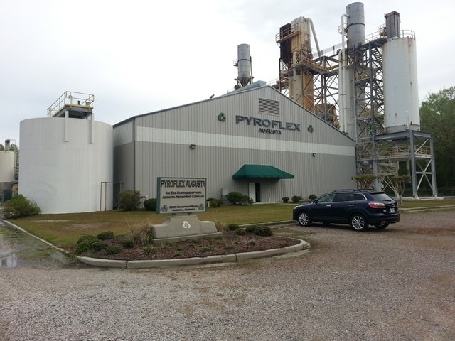
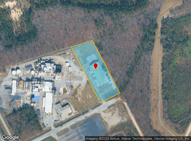
Property Record
2529 Newsprint Rd, Augusta, GA 30906
NEARBY LISTINGS FOR SALE OR LEASE
Property Detail
2529 Newsprint Rd
4000007050
2529 NEWSPRINT RD
Industrialacreage
Richmond
X
Georgia
13245C0230H
3.36 AC
2025
South Richmond County
2025
Augusta/Richmond County
010602
Augusta-Richmond County, GA-SC
10,000 SF
DEMOGRAPHICS near 2529 Newsprint Rd
1 Mile
3 Mile
5 Mile
2024 Total Population
9
5,235
14,625
2029 Population
9
5,213
14,629
Pop Growth 2024-2029
0.00%
(0.42%)
+ 0.03%
Average Age
30
38
38
2024 Total Households
3
1,990
5,296
HH Growth 2024-2029
0.00%
(0.30%)
+ 0.06%
Median Household Inc
$67,500
$58,357
$54,696
Avg Household Size
2.00
2.60
2.60
2024 Avg HH Vehicles
2.00
2.00
2.00
Median Home Value
$199,999
$151,741
$145,300
Median Year Built
1994
1986
1987
Nearby Places
- Restaurants
- Banks
- Shops
- Fitness
- Groceries
PUBLIC TRANSPORTATION
AIRPORT
Augusta Regional at Bush Field
DRIVE
WALK
Distance
Augusta Regional at Bush Field
14 min
5.8 mi
Freight Ports
Georgia Ports - Savannah
DRIVE
WALK
Distance
Georgia Ports - Savannah
139 min
106.9 mi
SALE & LEASE HISTORY
LISTING DATE
SALE/LEASE

Jul 27, 2018
For Sale
Nearby Properties
Address
Land Use
TOTAL SIZE
Lot Size
Zoning
Address
Land Use
TOTAL SIZE
Lot Size
Zoning
78,943 SF
1,319.60 AC
HI
Address
Land Use
TOTAL SIZE
Lot Size
Zoning
449,636 SF
31.57 AC
Address
Land Use
TOTAL SIZE
Lot Size
Zoning
16,664 SF
240.88 AC
HI_B-1_A
Address
Land Use
TOTAL SIZE
Lot Size
Zoning
403,560 SF
27.99 AC
HI_LI
Address
Land Use
TOTAL SIZE
Lot Size
Zoning
23,184 SF
6.88 AC
R-3C
Address
Land Use
TOTAL SIZE
Lot Size
Zoning
403,560 SF
27.99 AC
HI_LI
Address
Land Use
TOTAL SIZE
Lot Size
Zoning
4,356 SF
52.76 AC
A_R-MH_B-2
Address
Land Use
TOTAL SIZE
Lot Size
Zoning
437,452 SF
26.15 AC
HI
Address
Land Use
TOTAL SIZE
Lot Size
Zoning
720 SF
37.27 AC
HI
Address
Land Use
TOTAL SIZE
Lot Size
Zoning
12,430 SF
58.24 AC
HI
Address
Land Use
TOTAL SIZE
Lot Size
Zoning
437,452 SF
26.15 AC
HI
Address
Land Use
TOTAL SIZE
Lot Size
Zoning
Address
Land Use
TOTAL SIZE
Lot Size
Zoning
170,000 SF
10 AC
HI
Address
Land Use
TOTAL SIZE
Lot Size
Zoning
13,565 SF
151.34 AC
HI
Address
Land Use
TOTAL SIZE
Lot Size
Zoning
13,435 SF
270.98 AC
HI
Address
Land Use
TOTAL SIZE
Lot Size
Zoning
323.80 AC
HI
Address
Land Use
TOTAL SIZE
Lot Size
Zoning
29,620 SF
3.85 AC
HI
Address
Land Use
TOTAL SIZE
Lot Size
Zoning
12,665 SF
210.38 AC
A,B
Address
Land Use
TOTAL SIZE
Lot Size
Zoning
34,001 SF
9.33 AC
LI
Address
Land Use
TOTAL SIZE
Lot Size
Zoning
7,200 SF
3.33 AC
HI
Address
Land Use
TOTAL SIZE
Lot Size
Zoning
6,000 SF
5.34 AC
A
Address
Land Use
TOTAL SIZE
Lot Size
Zoning
10,948 SF
39.38 AC
LI COND
Address
Land Use
TOTAL SIZE
Lot Size
Zoning
10,780 SF
3.13 AC
B-2
Address
Land Use
TOTAL SIZE
Lot Size
Zoning
10,508 SF
2.78 AC
A
Address
Land Use
TOTAL SIZE
Lot Size
Zoning
1,100 SF
3.50 AC
HI SPEX
Address
Land Use
TOTAL SIZE
Lot Size
Zoning
2,098 SF
23.14 AC
A_HI
Address
Land Use
TOTAL SIZE
Lot Size
Zoning
1,800 SF
10 AC
HI
Address
Land Use
TOTAL SIZE
Lot Size
Zoning
4,584 SF
5.57 AC
003
Address
Land Use
TOTAL SIZE
Lot Size
Zoning
3,600 SF
1.30 AC
B-2
Address
Land Use
TOTAL SIZE
Lot Size
Zoning
9,000 SF
10.53 AC
HI
The World's #1 Commercial Real Estate Marketplace
Connect with us
© 2025 CoStar Group
The information above has been obtained from sources believed reliable. While we do not doubt its accuracy we have not verified it and make no guarantee, warranty or representation about it. It is your responsibility to independently confirm its accuracy and completeness. Any projections, opinions, assumptions, or estimates used are for example only and do not represent the current or future performance of the property. The value of this transaction to you depends on tax and other factors which should be evaluated by your tax, financial, and legal advisors. You and your advisors should conduct a careful, independent investigation of the property to determine to your satisfaction the suitability of the property for your needs.